
Norwegian Mountains, Møre og RomsdalBorgundgavlen, 71m
Borgundgavlen
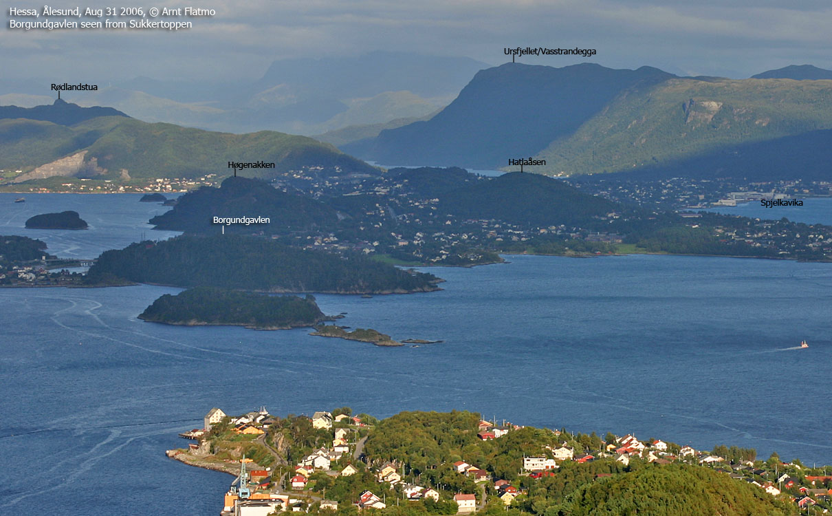
IntroductionBorgundgavlen is the westernmost top on Uksenøya island, approx. 4Km southeast of the centre of Ålesund. Borgund (the local area) is a small peninsula defined by the Nørvasundet strait and Katavågen - a bay in Borgundfjorden. On this peninsula, you will find Sunnmøre Museum and the Borgund church. Borgund has a number of forest trails and paths and is a very popular recreational area. Information boards about the forest are found throughout the forest. In various places, you'll get a good view towards Sula and the Ålesund region. A visit to Borgund is highly recommended! Let the pictures (see links at bottom of the page) inspire you. At the museum entrance, you find a good area map: 
Sunnmøre Museum info board
Primary factor:Borgundgavlen (Norge 1:50,000: 71m, Økonomisk Kartverk: 71m, UTM 32 V 357007 6929270) has a primary factor of 71m towards the higher parent mountain Høgenakken (130m). The defining saddle (approx. UTM 32 V 357596 6929482) is found by the entrance to Sunnmøre Museum. Ref. Økonomisk Kartverk (5m contours), the saddle is within the contours 0-5m, interpolated to 3m. A GPS reading at the high point recorded 75m as average over 175 samples. Error margin was +/- 4m. The waypoint on top eas 27m NE of the GPS 71m point. The forest is not a reliable place for accurate GPS measurements, but in theory, the high point could be 74m. Not 75m, as then there would have been a 75 contour on Økonomisk Kartverk.
Google map
Google's interactive map. You can zoom, pan and click on the markers.
Trail descriptions
Notes: Class ratings are in reference to YDS. Click here for more information.
The trails described below are not necessarily the *easiest* trails to this mountain.
Access (all distances are approx. distances) From Ålesund, follow highway E136->E39 towards Åndalsnes. At Nørvasundet, turn right towards Nørve/Gåseid. 370m later, turn left towards Gåseid. After 90m, just in front of the Borgund Sparebank building, turn right onto a large parking area and park here. The route Follow the road to the museum. Pass the main visitor building and follow a road up the hill. Here, you will pass a nature trail (natursti). On top of the hill, follow the road as it turns left, and at Vikstova, turn right onto the forest trail. 100m ahead, the forest loop begins. Turn right and follow the north side trail. A stub marks the high point. Shortly after you'll pass a fallen tree with a hole at the root and a viewpoint with good view towards Ålesund. Follow the trail as it takes you down on the south side of the ridge. The trail has been prepared to keep you (fairly) dry on wet days.
Having completed the loop, turn right and pass the church. Follow
the road from the church, and once you reach the bay (on your left-hand side),
turn left and follow a trail back to Sunnmøre Museum.
Pictures and Trip reports:
Other pictures
No Javascript:
|


