
|


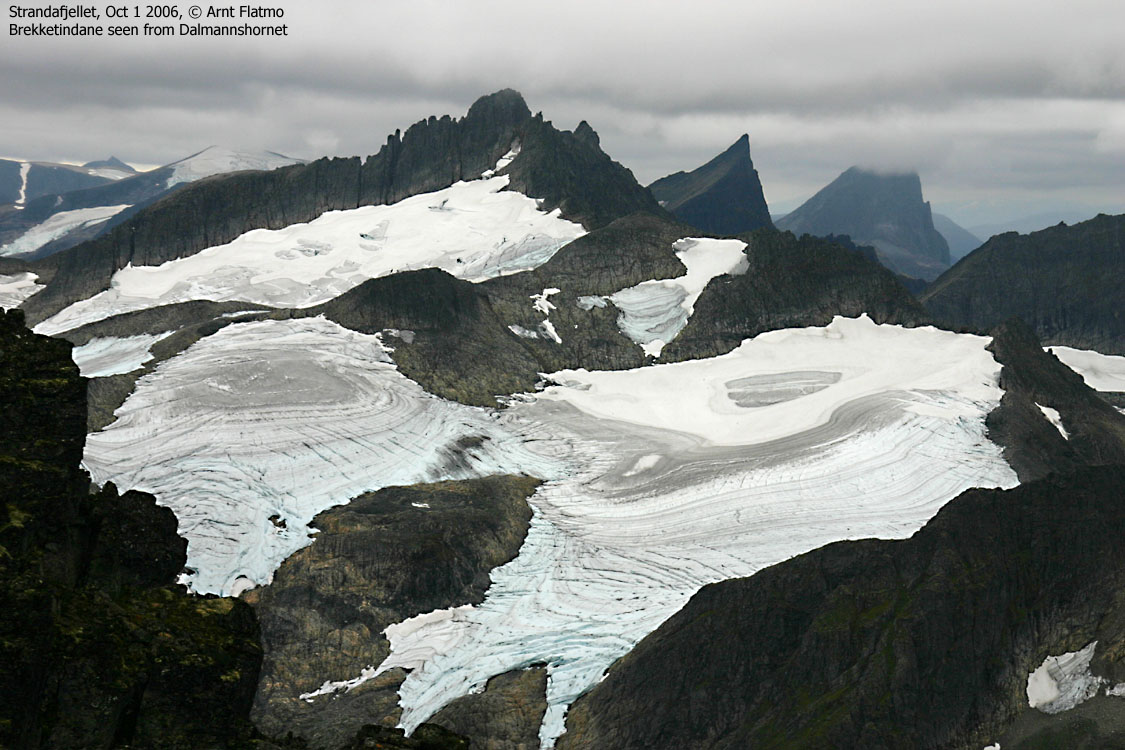
Brekketindane are considered to be among the very finest of the Sunnmørsalpene peaks. Ascending the highest peaks involve glacier crossing, scrambling and easy climbing in rugged and airy terrain. The Habostadbreen, Brekketindbreen and Gullmorbreen glaciers enclose the Brekketindane massif. Store Brekketind (1578m) is the highest of the peaks.
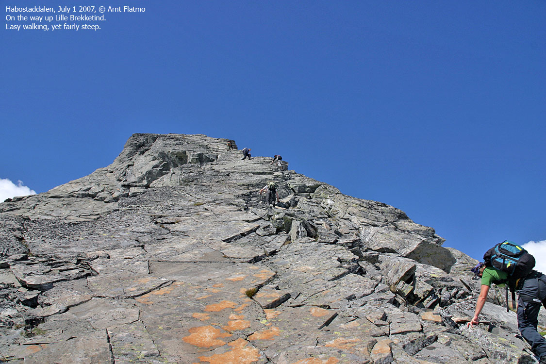
There are numerous pinnacles and pointy tops on this massif, and some have names. Lille Brekketind (1550) require glacier crossing on the normal route, while Søre Brekketind (1419m) and Sandgrovhornet (1345m) is normally reached via ridges up from Habostaddalen.
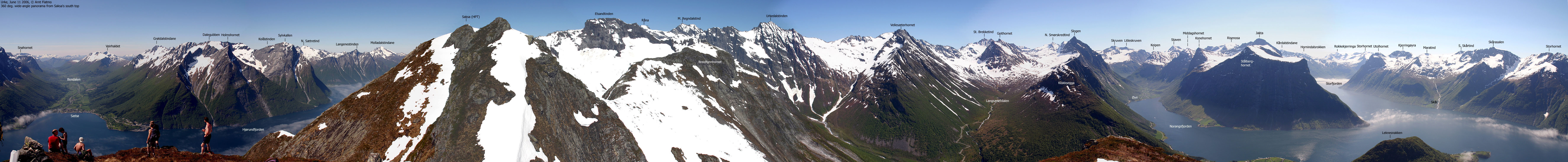
Store Brekketind is the second highest top on a long mountain range that runs between Slogen and Synnavindsnipa. Råna (1586m) is the highest top. Other notable tops on this range are Urkedalstinden, Vellesæterhornet, Geithornet, Brunstadhornet and Gullmorhornet. Habostaddalen separates this mountain range from the Smørskredtindane - Leirvasshornet - Storhornet range.
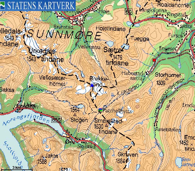
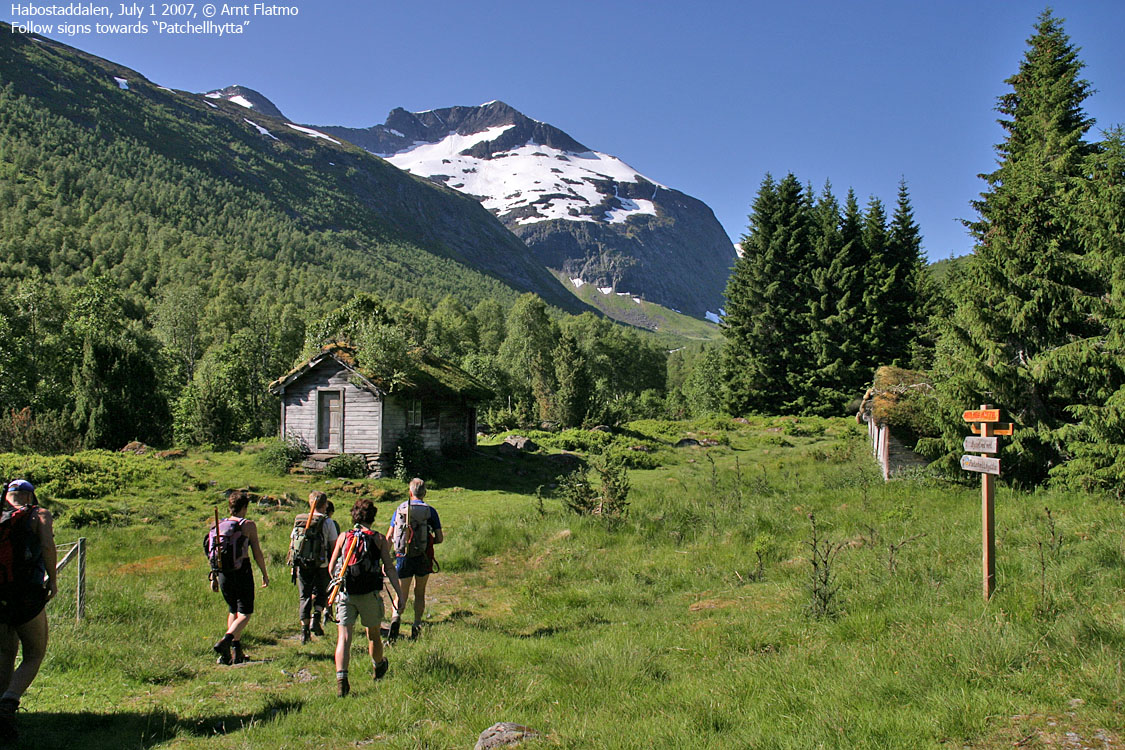
Store Brekketind is normally ascended via the Patchell Hut in Habostaddalen. The Patchell Hut is also a popular base for visits to Brekketindane's grand neighbours - Smørskredtindane and Slogen. Store Brekketind can also be reached from Vellesæterdalen, via the Gullmorbreen glacier. The upper scrambling/climbing route is common for both routes.


Available literature may give an impression that these tops are difficult to reach without the use of a rope. A rope is, as a general thumb of rule, necessary for glacier crossing, but at least Store and Lille Brekketind can be climbed without the use of ropes. Of course, this dependes on how comfortable the individual is with rough and airy terrain. It is reasonable to assume that an experienced hiker, comfortable with tops such as Slogen, Jakta, Kolåstinden, Romedalstinden (to name some) will not, under good conditions, face great difficulties on Store and Lille Brekketind.
However, the season for ascent of Store Brekketind is an important factor. As Brekketindbreen glacier extends (winter/early spring) all the way to the ridge crest, the transit from the glacier is smooth. But during snowmelt, this transit gets gradually more and more difficult. Consequencally, the rock climbing gets all the more easier. Thus, timing your visit is of the essence.

The routes on the Brekketindane massif are well described in the books Fotturar på Sunnmøre (Standal/Hagen/Wangen) and Sunnmøre (Randers). This web page will describe the route from Habostaddalen, valid for spring while the crest can still be reached on snow.
Store and Lille Brekketind are found on the Sykkylven/Ørsta kommune border. Søre Brekketind is located along this border too, but borders also to Stranda.


Store Brekketind (Norge 1:50,000: 1578m, Økonomisk Kartverk: -, UTM 32 V 380674 6901845) has a primary factor of 488m, towards the higher parent mountain Råna (1586m). The saddle (approx. UTM 32 V 379888 6902647) is found in the pass between Brekketindane and Gullmorhornet. Ref. Norge 1:50,000 (20m contours), the saddle height is within the range 1080-1100m, interpolated to 1090m.
Older literature refers to Brekketinden, 1571m. Personal GPS measurement read 1584m (2m error margin) on top of the cairn (max. 1m high) as average over 15 minutes.
Lille Brekketind (Norge 1:50,000: -, Økonomisk Kartverk: -, UTM 32 V 380458 6901633) has a primary factor that is not straightforward to calculate. According to the map contours, the top is less than 1540m high, but on the internet, the height 1550m is used.
Personal GPS measurement read 1553m (2m error margin) on top of the cairn (2m high) as average over 10 minutes. The primary factor of 30m is merely a guess.
Google's interactive map. You can zoom, pan and click on the markers.
Notes: Class ratings are in reference to YDS. Click here for more information.
The trails described below are not necessarily the *easiest* trails to this mountain.
|
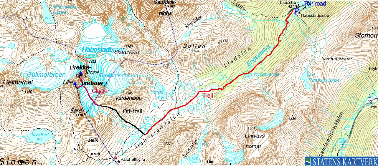
Liasætra - Store & Lille Brekketind (spring/summer)
|
|
Access
(all distances are approx. distances)
From Ålesund, follow highway E39 towards Bergen, and then highway RV60 (Stranda) to the Magerholm - Ørsneset ferry. This ferry runs quite often; every 20 minutes in the busy hours of the day. From Ørsneset, drive RV60 to Stranda (35Km). Turn southbound (right) and drive 1,9Km. Turn right towards "Engeset". After 4,2Km, the road turns to a gravel road by the self-served toll booth (NOK 25,- per July 2007). Proceed 3,8Km to the parking at Liasætra.

The route
Store Brekketind:
From Liasætra, followed the marked trail towards Patchellhytta. The trail is well worn and visible, crosses rivers on bridges and creeks on rocks.
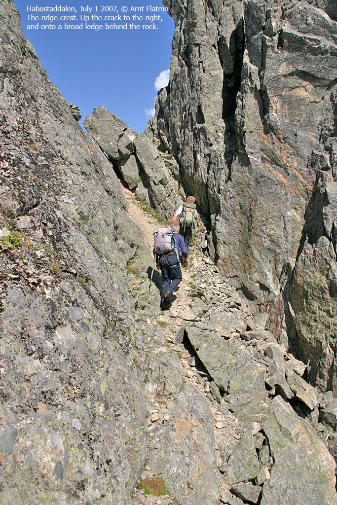
Approx. 1Km before you reach the Patchell Hut, find a good place to cross the rivers/streams. Head up the valley between Søre Brekketind and Sandgrovhornet. The glacier you are heading towards, is the "real" Brekketindbreen glacier. Traverse the glacier as a roped party and aim towards a distinct gap in the ridge, just left (west) of the block-shaped Store Brekketind.
A snow tongue extends up to this gap, and makes for an easy transit from the glacier to the ridge crest. When this tongue begins to melt, the difficulties increase gradually. Deal with them accordingly.
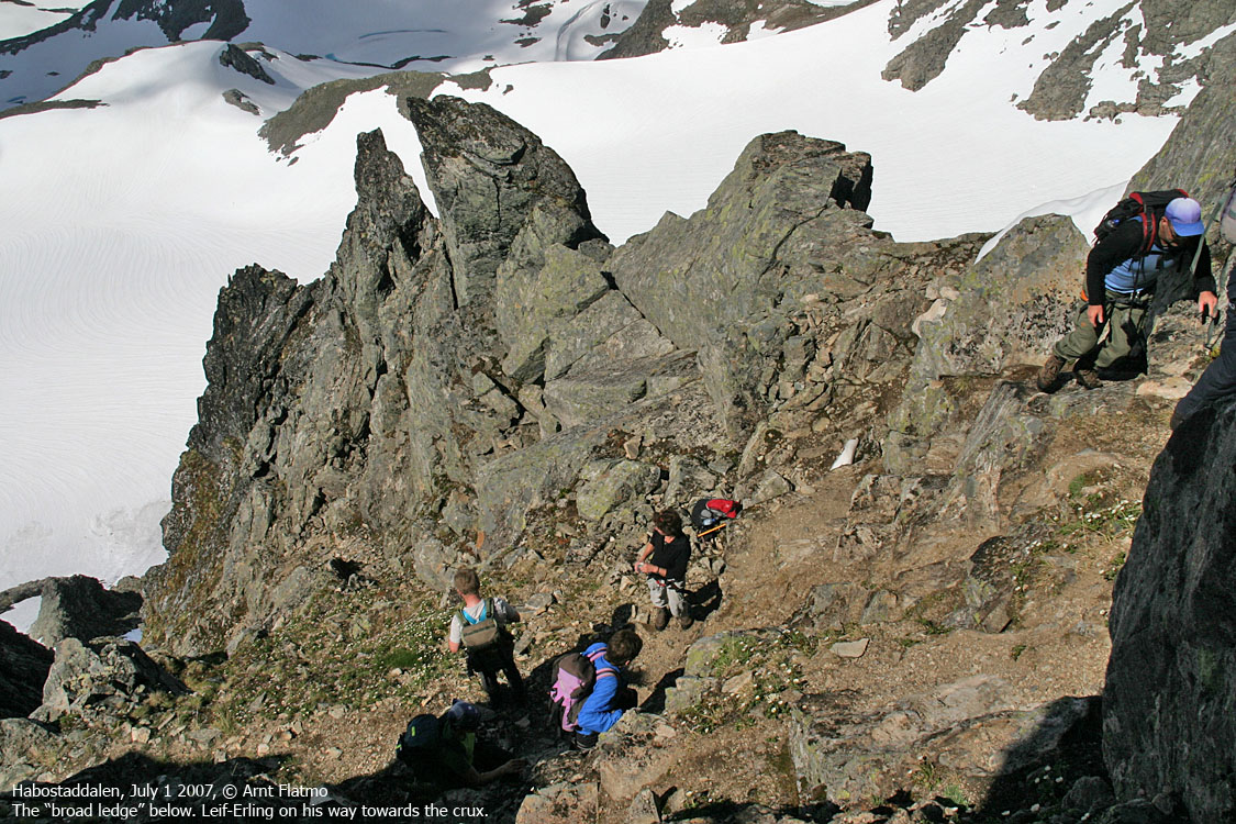
Once on the ridge crest, turn right and you'll enter a broad ledge. From this ledge, ascend (YDS class 2+) up to a corner. Climb up here (class 4) using a firm rock as handhold. Proceed to your right ascend up to another ledge just above (class 2+) which takes you to the summit ridge. On the summit ridge (class 2+) bypass the largest rocks by walking around on the right-hand side. The summit is marked by a small cairn.


Lille Brekketind:
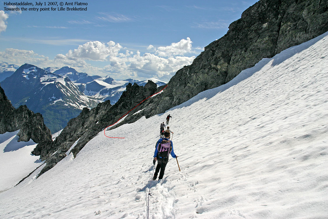
Return back down to the glacier and head southwest towards the normal entry point. Look for a snow tongue that can safely get you onto the ridge. Once on the ridge, proceed on slabs (steep class 2+/3) up to a 2m gap on the ridge. Downclimb this (exposed) gap face in (class 4) with great caution.
Alternatively, descend approx. 20m and look for a ledge to your right. Don't ascend on this ledge, but climb directly down from it. Follow ledges above the couloir down on your left. The ledges will take you back onto the ridge, just below the "2m gap". The ledges are not difficult to climb, but space is limited, there is exposure (towards the couloir) and there is sand and small rocks. YDS class 3 terrain.
The terrain from the "2m gap" and up to the summit is fairly trivial, class 2+. The summit is marked by a tall cairn. Upon descent, you'll (probably) find that climbing up the "2m gap" is FAR more easier than the climb down.
Back on the glacier, the descent route is the same as for Store Brekketind.
 westcoastpeaks.com
Other Møre & Romsdal mountains
Other Norwegian mountains
westcoastpeaks.com
Other Møre & Romsdal mountains
Other Norwegian mountains

