
|

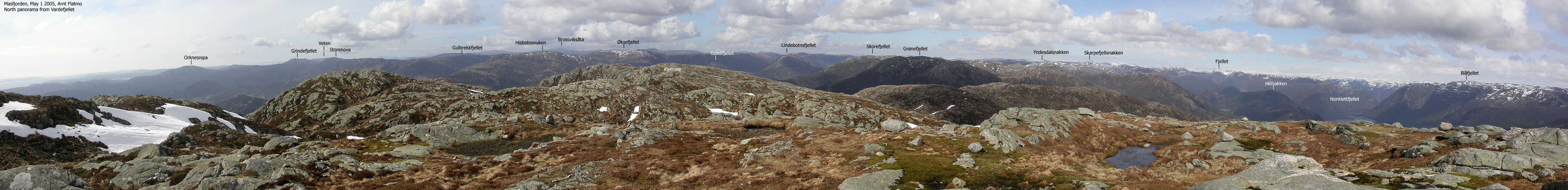
Grønefjellet (Green Mountain) is located on the southwest side of a mountain region that is defined by Masfjorden, highway E39 and the road from Hosteland to Brekke. The most prominent mountain in this region is Skarpefjellsnakken (782m). This large region with a number of tops is excellent for skiing in winter, and there are many trailheads.
The easiest route to Grønefjellet runs from Kvamsdalen, southwest of Grønefjellet. A forest road and a path takes you up to Kvamsdalsstølen, located at the bottom of Grønefjellet's southwest ridge. There may be a path up this ridge, but you don't need one.
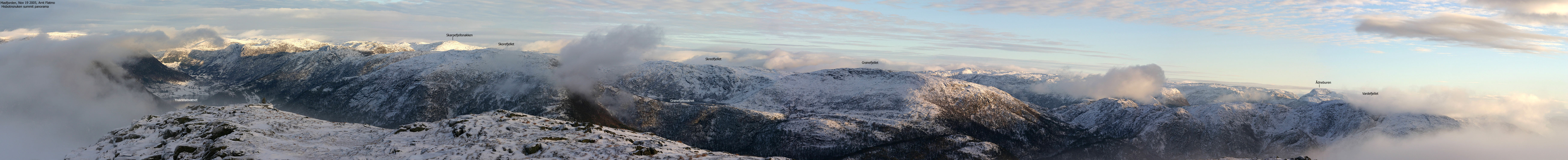
There are three viewpoint cairns on Grønefjellet; point 642m (west, 32 V 301572 6756819), point (approx.) 580m (south, 32 V 301636 6756227) and point (approx.) 654m (northeast, 32 V 301987 6756904). The high point (32 V 301805 6756885) is not marked in any way, but you will find a large rock here. This can be useful information should you find yourself up here in fog.
The views are quite good. Skarpefjellsnakken is higher, but does not obscure any interesting mountains beyond. I recommend that you make a roundtrip between the viewpoints to get a view towards the nearby valleys and fjords.

Grønefjellet (1116-I: -, Ø.K: 654,5m ~ 655m) has a primary factor of 102m towards the higher Skorefjellet (660m). The saddle is found on the ridge between Skorefjellet and Skarpefjellet. Ref. Økonomisk Kartverk (5m contours), you cross the 555m contours on the high route, but not 550m. The saddle height has been interpolated to 553m.
The summit point (32 V 301805 6756885) was measured to 656m by my GPS (no correction for error margins).
Notes: Class ratings are in reference to YDS. Click here for more information.
The trails described below are not necessarily the *easiest* trails to this mountain.
|
Kvamsdal - Grønefjellet (summer/autumn)
|
|
From Bergen, you have two main alternatives;
a) w/ferry (Leirvåg - Sløvåg)
From Bergen, follow highway E39 northbound. After the Nordhordlandsbrua bridge,
pay (NOK 45,- for passenger cars per May 2005) at the Toll station. Drive 2,4Km
and turn left onto highway RV57 (Leirvåg). Follow RV57 36,6Km, then turn
right right towards "Leirvåg". The ferry to Sløvåg is 1,4Km
from this exit. Note that the ferry sometimes stop by Skipavik, west of Sløvåg.
Per July 2005, the ferry schedule was published on
ruteinfo.net.
From Sløvåg, continue 3,9Km. Turn right onto RV57 towards Duesund. Follow this road 9,6Km (to Hosteland) and turn left towards Brekke (see below for further driving instructions)
Another ferry alternative is Masfjordnes - Duesund. A scenic, but not the fastest or shortest route.
b) Via Kringla:
From Bergen, follow highway E39 northbound. After the Nordhordlandsbrua bridge,
pay (NOK 45,- for passenger cars per May 2005) at the Toll station. Drive 66(++)Km
and at the Kringla junction, turn left towards Solheim/Duesund. Continue on this road
for 5,5Km and turn right towards Duesund. Drive 13,3Km (incl. along Masfjorden) and
turn right towards Rutledal.
Turn right and continue approx. 3,6 to the Brekke junction (Hosteland). Turn right here.
See below for further driving instructions.
(Another alternative is to drive along Haugsværfjorden via Solheim).
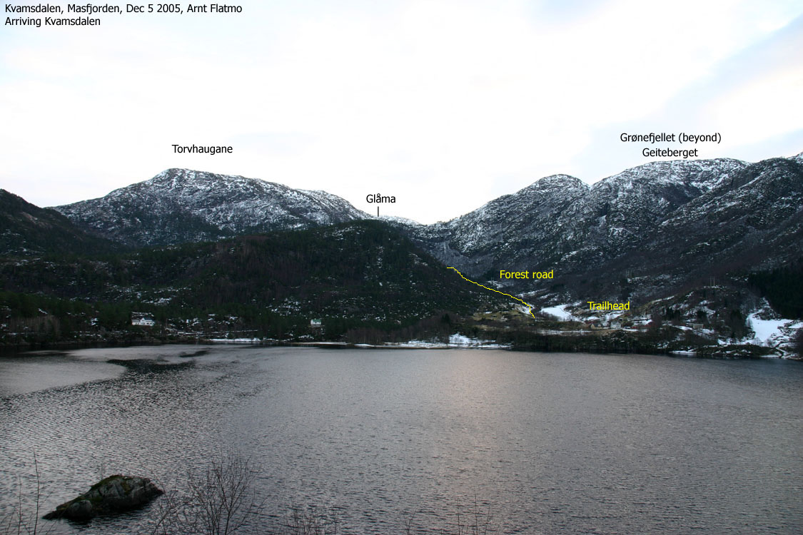
Road to Kvamsdal
Follow the road to Brekke approx. 8,3Km and turn right towards "Kvamsdal". Drive 1,2Km and you will have a forest road up to your left. Ask for permission to park, as there is no public parking available. Note that after 7,1Km on this road, you pass the trailhead for Hisbotnsnuken.
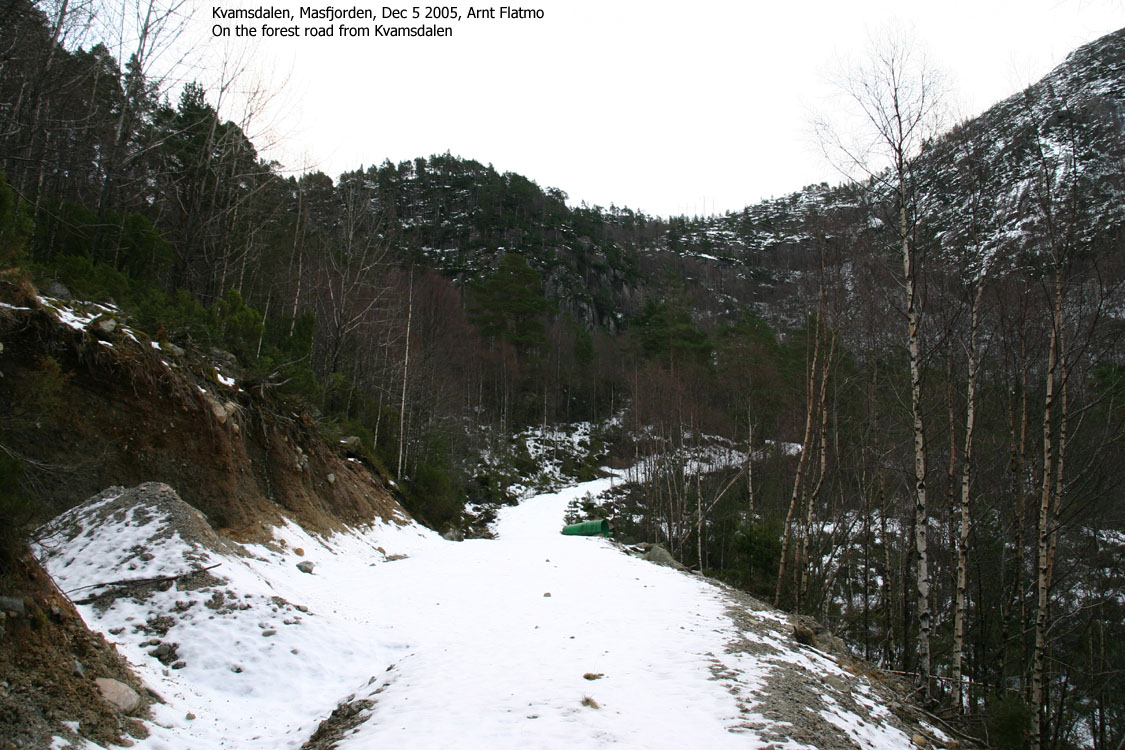
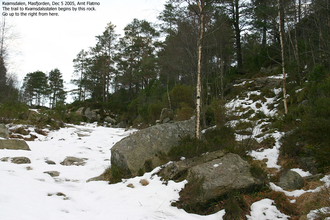
Follow the main forest road upwards. After approx. 900m, turn right onto a forest path when you see a large rock with a smaller rock on top. This is before the top of the forest road.
Follow the forest path approx. 350m and you will see a trailsign on a tree. Turn right towards "Kvamsdalsstølen". The path runs up a forest ridge and gradually heads into the valley on your left. Above this valley, you will see Grønefjellet's southwest ridge. Follow the path until you reach the lake (Setsetjørna) and see Kvamsdalsstølen on the other side of the lake. If you have problems locating the path, look at the trees for branches that have been cut off. On snow, these cut branches helped me stay on track on my December 2005 hike.
At the lake, turn left and follow Grønefjellet's southwest ridge upwards. You will see a cairn at approx. 580m elevation. Aim for this cairn and then continue to the high point, approx. 670m north-northeast. As mentioned, the high point is not marked, but you will see a large rock up there. The viewpoint cairn 180m further east is approx. the same elevation. My guess it is 1-2m lower than the high point.
Descend your ascent route, or make a direct shortcut from 420m elevation on the southwest ridge, directly down to the valley.


This Monday morning, early December, I was on my way to the last mountain on my Masfjorden list. This was my 18th trip to Masfjorden kommune i 2005, and this would be the 25th independent mountain (of 44) that I visited in 2005. In additon, I had also been to Illestigfjellet, which barely fell out of my Masfjorden list. Including this trip, I have paid NOK 1710,- in toll on the Nordhordlandsbrua bridge (for the Masfjorden mountains alone in 2005), and it is of no comfort that this bridge becomes toll-free in 2006.
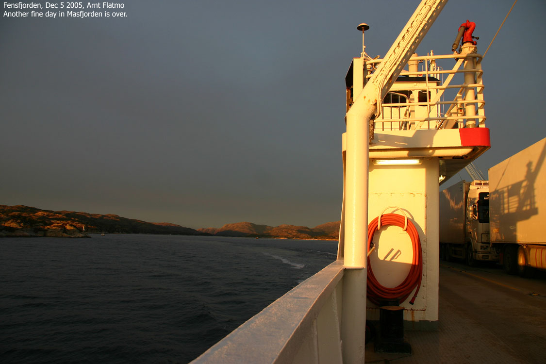
Enough of statistics, it was a nice day. I took the 09:25AM ferry from Leirvåg (by Mongstad) and after a short visit to Skipavik, we (the dog and I) arrived Sløvåg on the north side of Fensfjorden. I drove up to Kvamsdal, chatted with a couple of locals who explained the route up to Grønefjellet. I was offered convenient parking, and by 10:40AM, we were on our way up the forest road.
I had always figured that I would hike Grønefjellet from the east (Fossdalen), but on my recent visit to Hisbotnsnuken, a farmer explained that Kvamsdalen was the easiest trailhead. It pays off to talk to people.
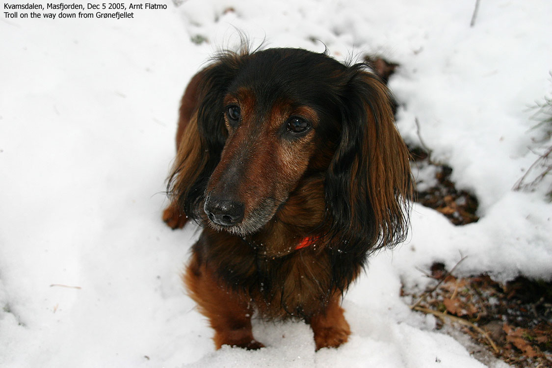
Troll lost faith in walking after "securing the area", and was installed in the backpack. I moved slowly up the forest road. There was just enough snow to steal away the energy. I located the forest path to Kvamsdalsstølen, which was, although covered by snow, easy to follow because of branches cut off the trees. Most of these branches pointed away from the path, which made me wonder if this was the local way of marking a path. In any case, it worked well for me, and I managed to stay on the path all the way to Kvamsdalsstølen.
It seemed obvious to head up the nearest ridge (the SW ridge) and so I did. I passed the 580m viewpoint cairn and proceeded up to the high point which I reached 12:25PM. I moved over to the NE viewpoint cairn for better views and had a lunch break there.
There was a cold, cold wind, and I had to put on all of the clothes I had in the backpack. Troll was shivering. I gave him a lunch box. I noticed how the shivering paused while eating, only to resume when the food was gone. I have been wondering if the shivering is a way to generate body heat, or if it is shivering as we humans know it? Or is it simply a "poor me" act?
On the way down the mountain, I took a shortcut down to the valley, and saved noteable time given the snow depth. Down in the valley, Troll was now willing to walk and even if I broke the trail (again) he still had to perform like a hare in order to keep up. We were back at the trailhead 13:55PM, giving me plenty of time for the 14:50PM ferry from Sløvåg. I left Masfjorden with a good feeling. The 43 mountains have taken time and effort but it was all well worth it.
Move cursor to read notes, and click on the images to see full version.
Some of the thumbnails may have been cropped to fit the format.
Pictures were taken with a Sigma 18-200mm objective, except for
3 panoramas (16,17,23) that were taken with a Canon 50mm objective.
To Kvamsdal


Ascent


Summit views


Descent


Heading back to Bergen


No Javascript:
1 2 3 4 5 6 7 8 9 10 11 12 13 14 15 16 17 18 19 20 21 22 23 24 25 26 27 28 29 30 31 32 33 34 35 36
Other hordaland mountains
 Other Masfjorden K. mountains
westcoastpeaks.com
Other Masfjorden K. mountains
westcoastpeaks.com

