
Kjetilsnuten, 1026mFylke/Kommune: Hordaland/Kvam Map: Primary Factor: 138m |
 Kjetilsnuten seen from Torefjellet |
Kjetilsnuten (M711: 1026m, Ø.K: 1026,5) has a primary factor of 113m towards the higher Geitafjellet (1255m). The saddle is found S of Skrivarnuten. Ref Økonomisk Kartverk (5m contours), you cross the 890m contours on the high route, but not 885m. The saddle height is interpolated to 888m.
Vossadalen trail from Lake Hamlagrøvatnet
| Difficulty: | Easy hiking. Minor scrambling a few places |
 |
| Risk: | Low in good weather | |
| Distance: | Approx. 20Km round-trip | |
| Time: | 5-7 hours | |
| Starting Elevation: | Approx. 500m |
Access:
From highway E16 at Dale or Bulken near Voss, take the road over Hamlagrø. At the southwest end of lake Hamlagrøvatnet (Osen), locate a parking area by the road. There is also parking down by the lake, but I don't know if these are reserved for cabin owners.
Kjetilsnuten trail:
The "T" trail starts by the west end of lake Hamlagrøvatnet. It begins as a road to the innermost cabins (see picture below). When you get to the small cabin village, follow the river a little upwards on a trail. When you get to a swinging bridge, the trail forks. Go over the bridge. Very soon after, the trail forks again. Go right. You are now heading into the Vossadalen valley, with Geitafjellet on your left.
It is almost 6Km to the top of the pass (Vending). After the pass, you arrive lake Solheimdalsvatnet. Pass this lake on the west side. Next, you descend down to lake Fugladalsvatnet. Before you reach the lake, as soon as you see the hut on the northern end, exit the "T" trail and turn left 10 o' clock. Head for the southern end of Geitafjellet. You see the mountains suddenly drops in elevation. The ridge next to Geitafjellet is Skrivarnuten, and this is where you are heading.
From where you exit the "T" trail, climb over a ridge, descend some and find another trail that runs above the lake. Don't focus too much on the trails, but make best effort to get to Skrivarnuten. From Skrivarnuten, the route to Kjetilsnuten is obvious. You need to descend approx. 100m before you can climb Kjetilsnuten.
In winter, the "T" marking will be covered by snow. However, getting to Vending by skis should be easy, just stay on the west side of Geitafjellet from lake Hamlagrøvatnet. I do not know about the conditions from Vending to Kjetilsnuten in winter, but don't expect this trip to offer any difficulties on skis.
Notes:
After rain, the hike up to Vending will make your feet soaking wet, unless you have 100% waterproof boots. I was hiking the trail very quickly, encouraged by unpredictable weather. I left the car 13:50PM, arrived Vending 15:10PM, and arrived Kjetilsnuten 17:15PM after wasting time looking for a way up Geitafjellet. I arrived the car at 18:50PM. You should plan for more. This is a long hike. My trip was measured to 20,4KM on my GPS.
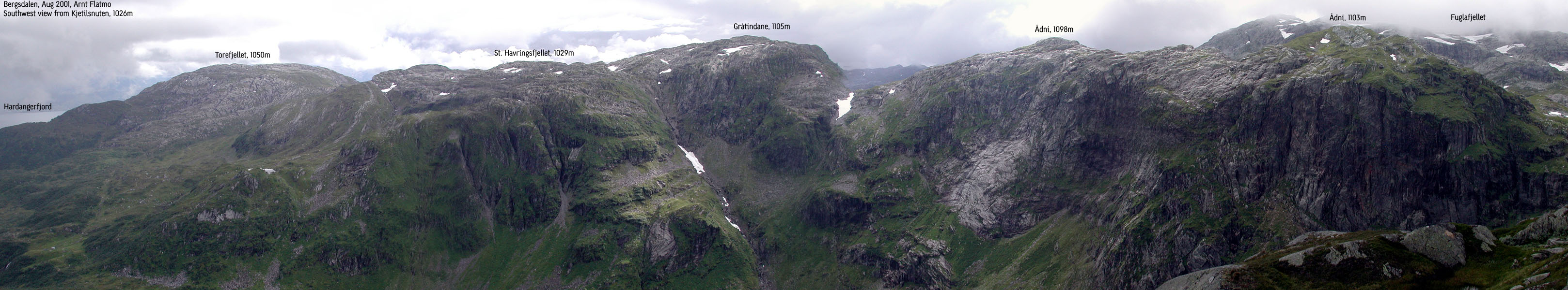
I will later hike Ådni from this trail, but Geitafjellet will be hiked from the Øystese side. Great views from Kjetilsnuten towards Fuglafjellet, Skrott and the Hardangerfjord.
Pictures: (move cursor to read notes, and click on the images to see full version)
Some of the thumbnails may have been cropped to fit the format


Pictures from other hikes:


 Other hordaland mountains
Other Kvam K. mountains
westcoastpeaks.com
Other hordaland mountains
Other Kvam K. mountains
westcoastpeaks.com