
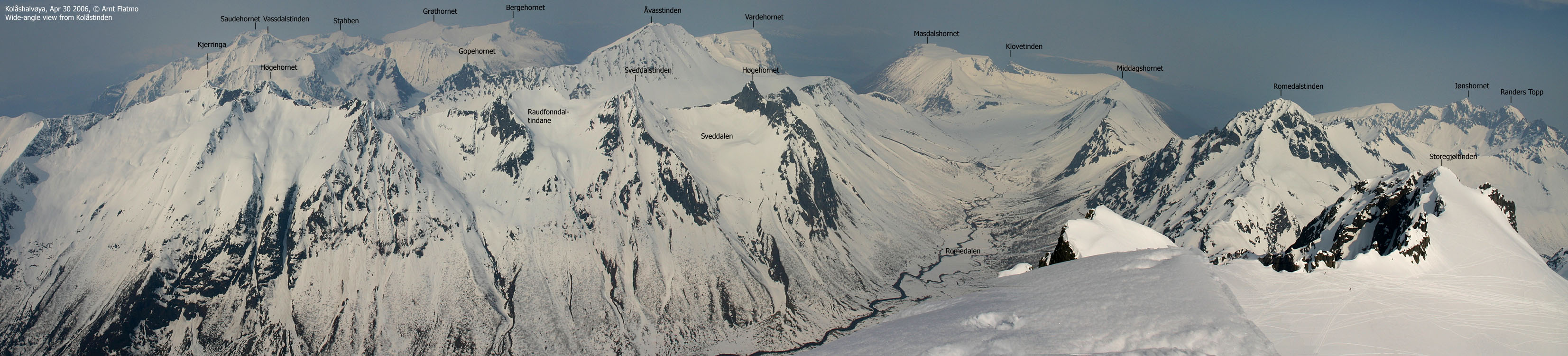
Norwegian Mountains, Møre og RomsdalKolåstinden on skis, Apr 30 2006To the main Kolåstinden page On the last day of April, I chose to visit this mighty mountain. My neighbours looked after my regular four-legged hiking partner while I set out to enjoy this beautiful spring day on one of Norway's finest mountains. Unfortunately, haze (the first in 2006!) would spoil the long-distance views you normally have from Kolåstinden, but I wouldn't let haze prevent me from going up there. Like on any popular Norwegian mountain in spring, it is wise to start early. I took the 07:30AM ferry to Festøya and was ready to leave the Kolåstinden trailhead near Standalhytta 08:30AM. There were *a lot* of cars parked along the road, because the annual skiing contest from Fingeren (a pinnacle south of Kolåstinden) would take place today. I can imagine that Standalhytta was absolutely overcrowded. I kept a fair pace (not fast) into Kvanndalen and was surprised that the snow was so hard. It was a warm day, and I dressed accordingly. Skiing wasn't very fun until I got higher up in Kvanndalen. I looked up to my left and saw Kolålstinden, the glacier and countless Telemark tracks down the glacier. Although tempting, I decided to stick with the regular route, both up and down. I was fairly sure I was the first one up the mountain this morning. I saw no fresh ski-tracks and no one up on the mountain. I was discouraged from skiing up to Stretet because of hard snow, and decided to walk on foot. The place I stopped had an icy crust and I decided to put on the crampons. This was not necessary, as the snow got a bit softer higher up. 5-10 minutes got "wasted" in two unnecessary technical stops. Once on the glacier, skiing upwards was easy. I skied up to approx. 1400m elevation and took the skis off. I headed up the final hill and barely got a glimpse of Romedalen (11:00AM) before I felt uncomfortable. My boots felt slippery on this mix of hard and soft snow. After noticing that the (very airy) high point was at least 10m further north, I climbed back down and put the crampons on. 11:10AM, I was standing on Kolåstinden high point and attempted to take pictures in "panorama order". Looking through the camera, while rotating made me feel dizzy and I decided to settle for shorter panoramas than usual. I vaguely noticed the astounding nature around me, as my primary focus was to find the right balance between the drop down to Romedalen and the cornices facing east. Back down by the skis, two skiers arrived and others followed shortly after. I could see a long line of skiers all the way from Kvanndalen and Stretet. Kolåstinden would be a crowded place within the next hour. None of the other skiers went onto the summit ridge. They climbed the steep hill and "clapped" the summit ridge, and I wondered how many (in, say, 100 people) actually went up to the high point. I skied over to Storegjøltinden, which was a "safer" place to take pictures from. Suddenly, it got very cold and I had to put on more clothes. After having lunch, I headed down at noon exactly. Skiing down to Stretet was fun, but I chose to walk down the other side of the pass. I had perfect skiing conditions in the upper part of Kvanndalen, but I ran into problems with short skis in "butter snow" further down in the valley. I was back at the car exactly 12:30PM and couldn't take my winter clothes off soon enough. It was probably 17-18 deg. C. at the trailhead. I did consider skiing up to Sylvkallen but ended up calling it a day. After a nice drive along Hjørundfjorden, I had to wait approx. 20 minutes for the ferry. I was back at the house 14:00PM, where the neighbours and the dog were relaxing in the sunshine. I let the dog enjoy the fine day a bit longer until we headed over to Rollandstua for an evening walk. With 1400 vertical meters in one day, I was quite content when the evening came. |


