
Norwegian Mountains, Møre og RomsdalKvasshornet, 1409m
|
| Fylke/Kommune : | Møre og Romsdal/Stranda,Ørsta | ||||||||||
| Maps : | 1219-III Hjørundfjord (Statens Kartverk, Norge 1:50 000) | ||||||||||
| Primary factor : | Kvasshornet: 760m | ||||||||||
| Primary factor : | Jolhornet: 20m | ||||||||||
| Hiked : | May 2008 | ||||||||||
| See also : |
| ||||||||||
| See also : | Other Ørsta mountains |
Jolhornet and Kvasshornet
(Click for larger image)
The name:
The top this page describes as Kvasshornet may actually be Jolhornet, and the top this page describes as Jolhornet may be unnamed. A spur north of the highest top may be Kvasshornkollen, but here is an overview of what the various sources say:
| Norgesglasset 1:50,000 |
Sunnmørsalpane Turkart 1:50,000 |
"Sunnmøre" (Randers) |
"Fotturar.."/"Skiturar.." (Standal,Hagen,Wangen) |
|
| The highest top (1409m) | Jolhornet | Kvasshornet | Jolhornet | Kvasshornet |
| The top south of 1409m | - | Jolhornet | - | Jolhornet |
| The top north of 1409m | Kvasshornet | Kvasshornkollen | - | - |
According to locals who knows the mountains around Rognestøyldalen well, Jolhornet is the name used for the main top, while Kvasshornet is the satellite peak just north of the main top. This matches the information found on Norgesglasset
This web page will (incorrect as it may be) refer to the highest top as Kvasshornet, the southern top as Jolhornet and the northern top as Kvasshornkollen, in line with the Sunnmørsalpane Turkart map. The main reason is because text was put on the pictures before new information about the mountain names was obtained.
The mountain:
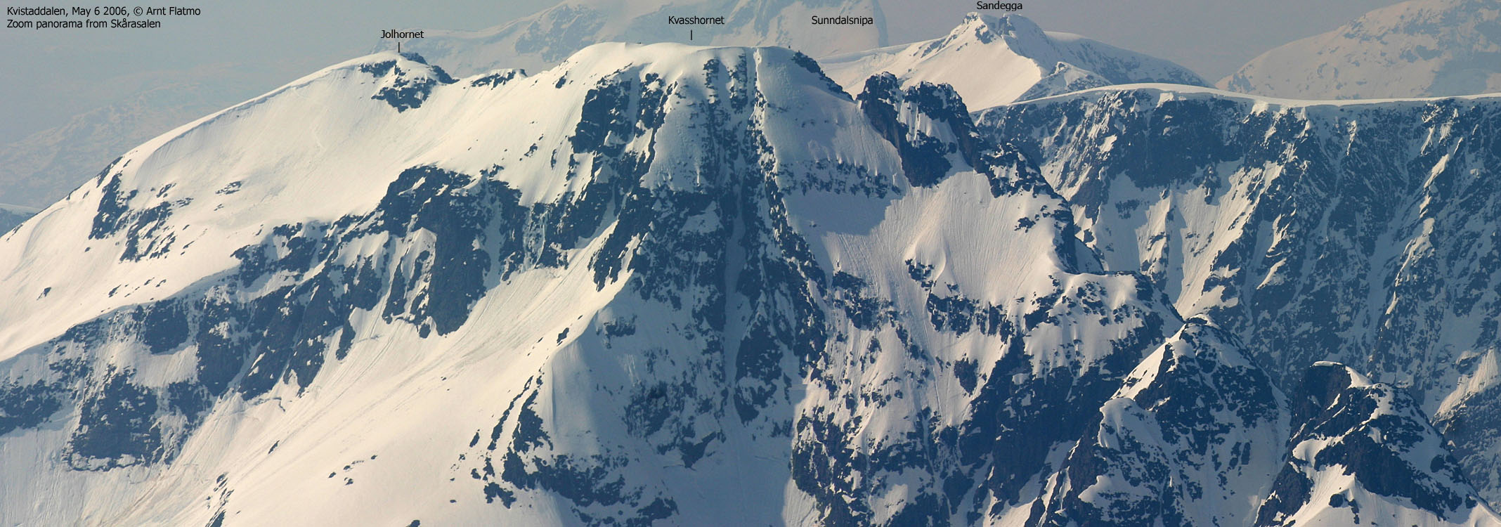
Kvasshornet is the highest top in the mountain range stretching between Aldalen
and Skjåstaddalen. Other peaks in this range are (a.o.) Storetinden (1408m),
Snøhornet (1309m) and Sandegga (1389m). To the east, Rognestøyldalen and
Bakkedalen meet in a pass at 649m.
The normal ascent routes run from Rognestøyldalen via Inste Tverradalen and from Bakkedalen. Both routes join in the Jolhorhet - Kvasshornet pass at (approx.) 1090m. Access to Kvasshornet is known to be easier in winter/spring, opposed to summer/autumn. A cliff between Jolhornet and Kvasshornet needs to be passed on the outside, and this is easier on snow:

The cliff seen from Jolhornet
(Click for larger image)
Access in summer will require scrambling past this cliff, which can (ref. others) be passed on both sides. There is however enough exposure to call for a rope to be used on this section. The rest of the route does not require a rope.
This web-page will describe a spring route from Bakkedalen to Kvasshornet via Jolhornet.
Kvasshornet's official height is 1409m, which is only 1m higher than its neighbour Storetinden (1408m). 1409m may refer to the cairn base at UTM 32 V 366088 6889891, or the highest point, slightly higher than the cairn, UTM 32 V 366124 6889846, approx. 60m southeast of the cairn. A GPS waypoint at the (seemingly) highest point (with snow) reported 1413m (1m error margin) as average over 15 minutes. This point was less than 2m higher than the base of the cairn, which means that Kvasshornet could be slightly higher than 1409m when the snow depth has been deducted.

Jolhornet seen from Kvasshornet
(Click for larger image)
Kvasshornet (Norge 1:50,000: 1409m (Jolhornet), Økonomisk Kartverk: 1409m, UTM 32 V 366124 6889846) has a primary factor of 760m towards the higher parent mountain Dukhornet (1412m). The defining saddle (approx. UTM 32 V 367206 6890936) is found between the two tops. Ref. Økonomisk Kartverk (5m contours), the saddle is defined through a fixed point - 649m.
Jolhornet (Norge 1:50,000: -, Økonomisk Kartverk: - (highest contour is 1380m), UTM 32 V 366213 6889425) has a primary factor of 20m towards the higher parent mountain Kvasshornet (1409mm). The defining saddle (approx. UTM 32 V 366201 6889526) is found between the two tops. Ref. Norge 1:50,000 (20m contours), the saddle is within the contours 1360-1380m, interpolated to 1370m.
A quick personal GPS measurement on Jolhornet read 1393m with an error margin of 3-4m.
Google's interactive map. You can zoom, pan and click on the markers.
|
|
|
Notes: Class ratings are in reference to YDS. Click here for more information.
The trails described below are not necessarily the *easiest* trails to this mountain.
|
Route 1: Bakkedalen - Jolhornet - Kvasshornet (spring)
|
|
Access
(all distances are approx. distances)
The starting point for this route description is Volda. Go southeast and follow signposts towards Fyrde/Austefjord. At Fyrde/Austefjord, don't turn right towards Straumshamn, but keep driving straight ahead towards Viddal. At Kalvatn, the road turns northeast towards Bjørke and Viddal (don't take the road towards Norfjordeid). As this is being written, the Kvivsegen road is under construction, so no distances are given.
As you approach Bjørke, stay left in the forks. Follow the road to Finnes and locate the toll road to Bakkedalen. Per Apr 2011, the fee for passenger cars is NOK 30,-. Cash only. Drive all the way up to Bakkedalssætra (or as long as the snow permits) and - if possible - turn right and drive up Bakkedalen until you see the bridge on your left hand side.
Statistics; On May 25 2008, we could drive all the way up to the bridge. On Apr 23 2011, we could drive to the east side of Bakkedalsvatnet (900 meters east of Bakkedalssætra), but we had to pass a very troublesome point further down the road.
The nearest airport is Hovden Lufthavn, located 10 minutes (driving distance) north of Volda.
The route

The route to Jolhornet/Kvasshornet
(Click for larger image)
Cross the river across the Bakkedalen river on a bridge, and proceed towards the valley south of Jolhornet. Keep well to the left to avoid avalanches and cornices coming down from Jolhornet. Spring avalanches from the south side of the valley are steeper and don't run too far into the valley. The current snow conditions will tell you which route is best. Proceed up to the Storetinden - Jolhornet ridge.
Either follow the ridge to the top of Jolhornet, or ski up Jolhornet's south flank, which may be avalanche-prone. Cross Jolhornet and descend towards the base of a cliff that blocks further access on the ridge towards Kvasshornet. Pass this cliff to the right (east). Passing the cliff should be easy on spring snow, but before the snowbridge that connects the cornice east of the cliff and the ridge, melts away.
Proceed along the ridge up to Kvasshornet. The viewpoint is marked by a tall cairn. The high point is found approx. 60m southeast of the cairn. Be aware of cornices facing east. Descend your ascent route.
In summer, it is possible to traverse Kvasshornet via
Kvasshornkollen (1190m). This is an exposed scrambling route, but experienced
scramblers may choose not to use a rope.
 westcoastpeaks.com
Other Møre & Romsdal mountains
Other Norwegian mountains
westcoastpeaks.com
Other Møre & Romsdal mountains
Other Norwegian mountains


