
|

Veten (not to be confused with Veten on Hidsegga) is the southernmost independent top on Gurskøya island. The top is an excellent viewpoint towards the northern Vanylven mountains, and is easily reached on a well traveled path. The summit cairn is unusually tall, approx. 3m. The path begins from highway RV61, and continues towards Keipen.
The name implies that the top was part of the coastal defense system, beginning from the Viking age. But the top is not mentioned in the book Den Norske Leidangen (1950). The book does however mention Viten på SV-siden av Gurskøy, 471m. Sandehorn.. There is no 471m top on the southwest side of Gurskøya, so this top might be the top that the book refers to.

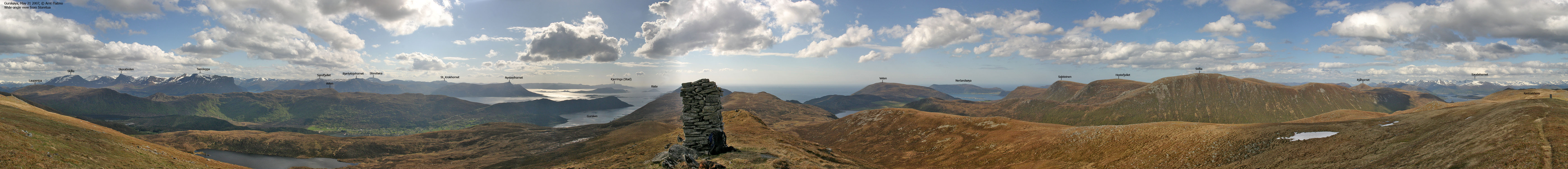
Grøthornet is a lower top, located 2,1km northwest of Veten. A marked path runs from Drageskaret - the same trailhead as for Veten.
Veten (Norge 1:50,000: 458m, Økonomisk Kartverk: Highest contour is 455m, UTM 32 V 325305 6901092) has a primary factor of 205m, towards the higher parent mountain Laupsnipa (558m). The saddle (approx. UTM 32 V 328631 6901606) is found between lakes Tødenesvatnet and Slokevatnet. Ref. Økonomisk Kartverk (5m contours), the saddle height is within the range 250-255m, interpolated to 253m.
Grøthornet (Norge 1:50,000: 298m, Økonomisk Kartverk: 298m, UTM 32 V 323333 6901780) has a primary factor of 50m, towards the higher parent mountain Veten. The saddle (approx. UTM 32 V 323790 6901861) is found between lakes Svartevatnet and Morkevatnet. Ref. Økonomisk Kartverk (5m contours), the saddle height is within the range 245-250m, interpolated to 248m.


Google's interactive map. You can zoom, pan and click on the markers.
Notes: Class ratings are in reference to YDS. Click here for more information.
The trails described below are not necessarily the *easiest* trails to this mountain.
|
RV61 - Veten (summer/autumn)
|
|
Access
(all distances are approx. distances)
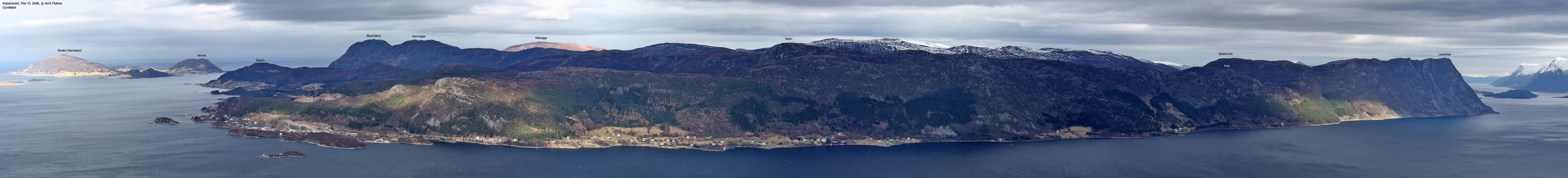
The nearest larger city is Ålesund. From Ålesund, follow highway E39 towards Bergen, and then RV61 towards Hareid. Take the Sulesund - Hareid ferry, and from the roundabout in Hareid, follow RV61 19,8Km to the RV61/RV654 junction 1Km after the Dragsundet bridge. You pass Ulsteinvik and make a sharp right turn (Måløy) along the way.
From the RV61/RV654 junction, follow RV61 and drive 14,9Km to the top of the road between Gursken and Larsnes. Find parking on your left-hand side.


The route
From the parking area, follow a signed path towards Veten. The path climbs all the way to the Svedahornet path fork, and then levels out. Svedahornet is not found on the map, but it is the hilltop (405m) 220m southeast of Knottahornet. In-between, you'll pass Lake Svedevatnet. The path continues directly towards Veten. There are some ups and downs along the way. Below Veten, you'll pass between lakes Langvetevatnet and Nyksvatnet. Veten summit is marked by a 3m tall cairn. Descend your ascent route.


No Javascript:
 westcoastpeaks.com
Other Møre & Romsdal mountains
Other Norwegian mountains
westcoastpeaks.com
Other Møre & Romsdal mountains
Other Norwegian mountains

