
Norwegian Mountains, Møre og RomsdalMasdalhornet (Vartdalhornet), 977m
|
| Fylke/Kommune : | Møre og Romsdal/Ørsta | ||||||||
| Maps : |
1219-IV Sykkylven (Statens Kartverk, Norge 1:50 000)
1119-I Ålesund (Statens Kartverk, Norge 1:50 000) |
||||||||
| Primary factor : |
Masdalhornet: 307m Storhylla: 50m Trongegga: 69m |
||||||||
| Hiked : | June 2008 | ||||||||
| See also : |
| ||||||||
| See also : | Other Ørsta mountains |
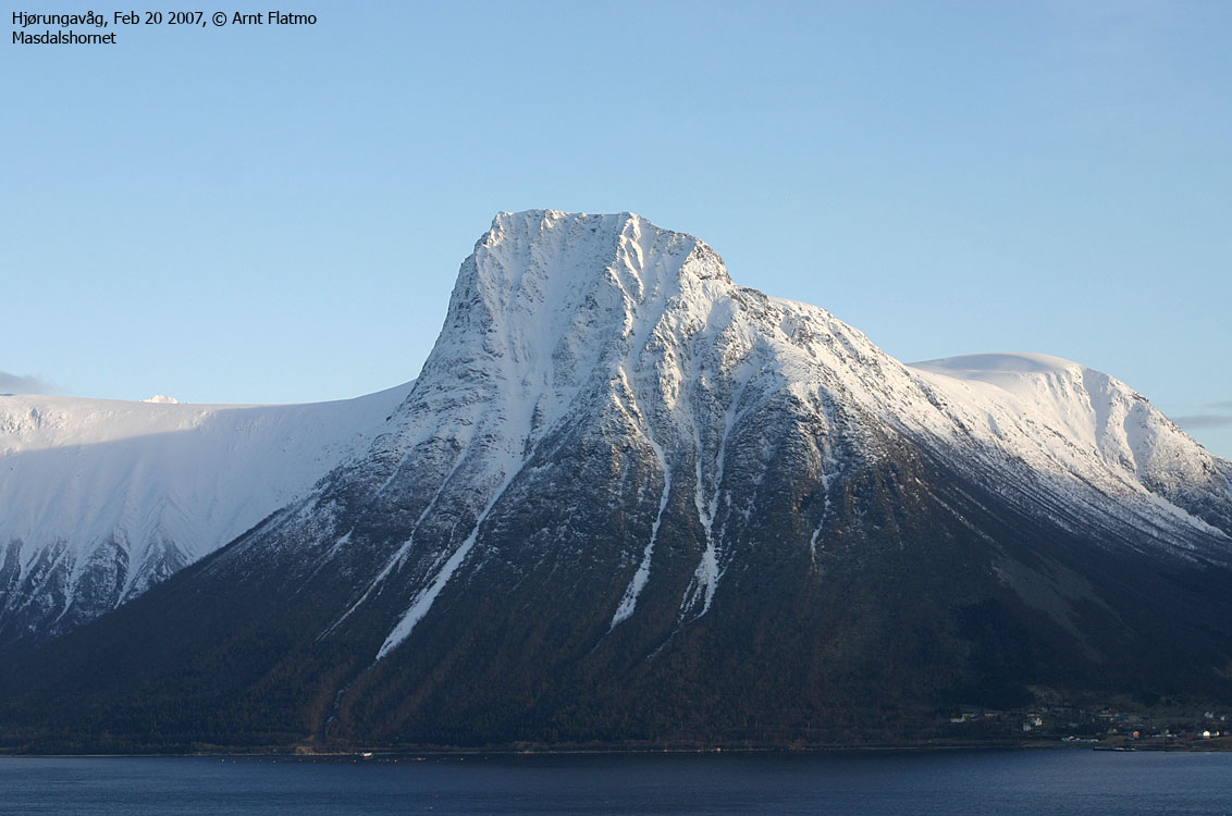
Masdalhornet
(Click for larger image)
Masdalhornet is a magnificent peak, rising steep up from Vartdalsfjorden. To the southeast, Masdalhornet connects to the huge and gentle plateau comprising Storhylla (big ledge) and Trongegga (narrow ridge). Through a pass at 670m elevation, this plateau connects to the (far) more rugged mountain range that includes Middagshornet, Romedalstinden and Kolåstinden. To northeast, Masdalhornet connects to Klovetinden via the distinct Masdalskloven gap.
The normal routes to Masdalhornet start from Høgebakken (Vartdalsætra) in Årskogdalen (south side) or from Barstadsætra in Barstaddalen (see the Middagshornet page for the Barstadsætra trailhead). The routes join in the Trongegga - Middagshornet saddle at 670m elev. This web page will describe the route from Årskogdalen, an overall easy route (YDS 2). Trongegga is a somewhat narrow ridge on top, but even those who lack a strong head for heights should be well off. Trongegga in winter will seem like a more exposed place.
The views from Masdalhornet are grand. You have a 1st class view towards Molladalstindane, Romedalstinden and Kolåstinden, in addition to a coastal panorama from Ytre Søre Sunnmøre to Romsdal. On top of this, you get to see directly almost 1000m down to Vartdalsfjorden.

Masdalhornet seen from the air
(Click for larger image)
Masdalhornet (Norge 1:50,000: 977m, Økonomisk Kartverk: 976,96m, UTM 32 V 354170 6913780) has a primary factor of 307m towards the higher parent mountain Middagshornet (1091m). The defining saddle (approx. UTM 32 V 356843 6911025) is found between Trongegga and Middagshornet. Ref. Norge 1:50,000 (20m contours), the saddle is within the range 660-680m, interpolated to 670m.
Storhylla (Norge 1:50,000: 960m, Økonomisk Kartverk: 960m, UTM 32 V 355649 6912958) has a primary factor of 50m towards the higher parent mountain Masdalhornet (977m). The defining saddle (approx. UTM 32 V 355170 6913082) is found on the plateau towards Masdalhornet. Ref. Norge 1:50,000 (20m contours), the saddle is within the range 900-920, interpolated to 910m.
Trongegga (Norge 1:50,000: 959m, Økonomisk Kartverk: 959,37m, UTM 32 V 356084 6911626) has a primary factor of 69m towards the higher parent mountain Storhylla (960m). The defining saddle (approx. UTM 32 V 355760 6912091) is found on the plateau towards Storhylla. Ref. Norge 1:50,000 (20m contours), the saddle is within the range 880-900, interpolated to 890m.
From the GPS track log: In the 5 minutes spent while walking across Storhylla high point, no track point was below 965m. The highest point recorded was 974m. A waypoint at the (seemingly, as there is no cairn) highest point read 972m, with 3-4m error margin. Waypoints from Trongegga and Masdalhornet was more in line with the map heights, which means Storhylla is probably higher than 960m.
Google's interactive map. You can zoom, pan and click on the markers.
|
|
|
Notes: Class ratings are in reference to YDS. Click here for more information.
The trails described below are not necessarily the *easiest* trails to this mountain.
|
Route 1: Høgebakken - Masdalhornet (summer/autumn)
|
|
Access
(all distances are approx. distances)
The nearest larger city is Ålesund. From Ålesund, follow highway E39 towards Bergen/Volda to the ferry at Solavågen. Take the ferry over to Festøya. Turn right in the direction of Volda and follow the road 12Km to Nordre-Vartdal. Turn left (signed "Årskog"), then turn left and cross a bridge. After 1,7Km (from E39), pay toll at a self-served toll booth. The fee for passenger cars per June 2008 was NOK 20,-. Proceed to road end at Vartdalsætra/Høgebakken, 4,5Km from E39. The road is gravel and bumpy from 1,6Km to 4,5Km.
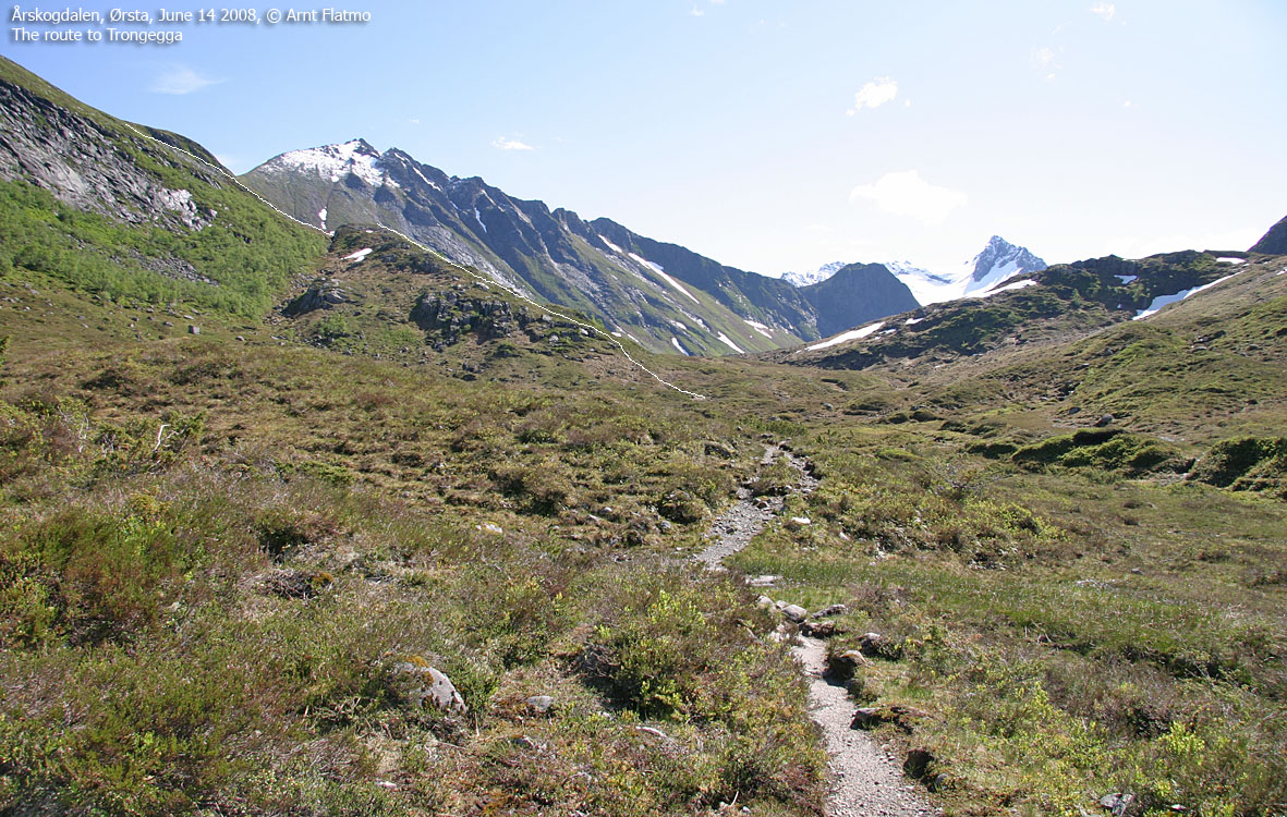
The route

The route from Årskogdalen
(Click for larger image)
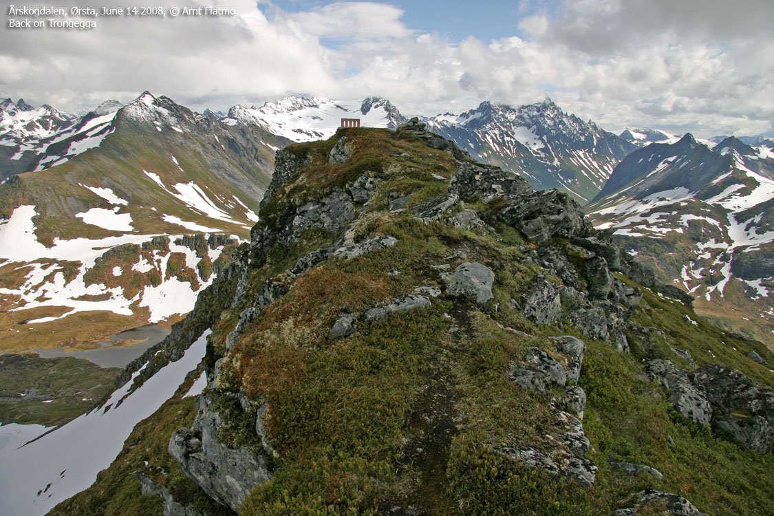
Follow the trail towards Romedalen approx. 600m, then turn left onto a distinct ridge. Follow this ridge, northeast up to 550m elevation, then northwest up towards Trongegga. It will all seem obvious. Trongegga summit is marked by a trigonometric point.
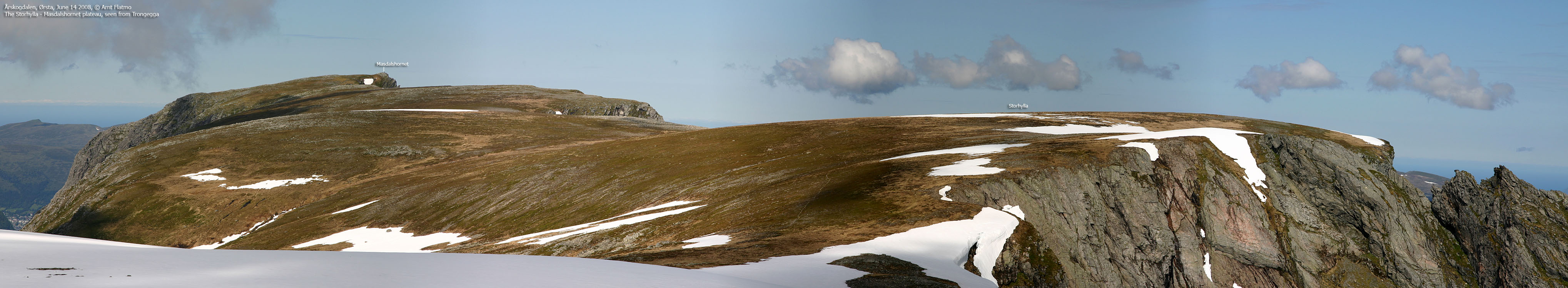
After a short descent, you enter the large plateau and follow the edge facing north/east for best views. Pass Storhylla (not marked) before you set course for Masdalhornet, which is marked by a cairn and a fallen trigonometric point. Descend your ascent route.
 westcoastpeaks.com
Other Møre & Romsdal mountains
Other Norwegian mountains
westcoastpeaks.com
Other Møre & Romsdal mountains
Other Norwegian mountains


