
|

Skåla (the bowl) is the highest mountain in a -large- region, which comprise the north side of Romsdalsfjorden/Moldefjorden/Langfjorden, the west side of Tingvollfjorden/Sunndalsfjorden, and far, far up along the coastline. The mountain is located on the Skålahalvøya peninsula, along with a half-dozen other tops. It is also the highest mountain in Molde kommune, and as such, a popular mountain.
With roads on both the north and south side of the mountain, there are several possible routes, but this page describes access from the place Kortgarden on the north side of the mountain, and a traverse across Skålaksla (1076m) and Skåla (1128m). This is a fairly straightforward traverse that does not involve exposure or any other difficulties than sometimes walking in rocky terrain and somewhat steep mountainsides.
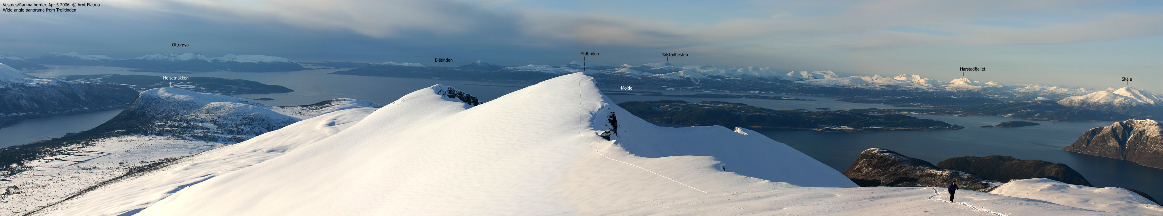
The mountain is famous for its views, and with several hundred tops in a 360 degrees panorama around you, you will not be disappointed. Those who would like a less straightforward approach, can probably find some fun routes up the scree-gullies above Lake Trollvatnet.
Skåla (Norge 1:50,000: 1128m, Økonomisk Kartverk: 1127,74m, UTM 32 V 429422 6957235) has a primary factor of 1030m towards the higher parent mountain Åbittinden (1396m) The defining saddle (approx. UTM 32 V 456114 6963087) is found near the place Toven, located between Langfjorden and Tingvollfjorden. Ref. Økonomisk Kartverk (5m contours), the saddle is within the range 95-100m, interpolated to 98m. Økonomisk Kartverk does not conform with the 1:50,000 map, where the adjacent contours are 120m, and not 100m.
Personal GPS measurement averaged the elevation to 1136m, over a 10-minute period. The GPS was located on top of the cairn, which is perhaps 2m high. The GPS accuracy was reported to be 1m.
Skålaksla (Norge 1:50,000: 1076m, Økonomisk Kartverk: 1076m, UTM 32 V 430394 6957324) has a primary factor of 66m towards its higher parent Skåla. GPS measurement averaged to 1079m over a 5-minute period, with a reported accuracy of 1m.


Notes: Class ratings are in reference to YDS. Click here for more information.
The trails described below are not necessarily the *easiest* trails to this mountain.
|
Kortgarden - Skålaksla - Skåla roundtrip (summer/autumn)
|
|


Access
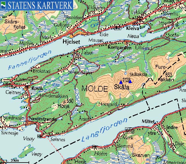
The starting point for this trip is the city of Molde. To get there from Ålesund, follow highway E39 approx. 56,5Km from the Moa/Breivika roundabout, and then take the Vestnes - Molde ferry.
From Molde, follow E39 eastbound (you go through two roundabouts after leaving the ferry) and turn right onto highway RV64 (Åndalsnes/Bolsøya) 3,5Km after leaving the ferry. Follow RV64 (through underwater tunnel and across the fjord on a bridge) 10,1Km and turn left when you see the "Kleive" sign.
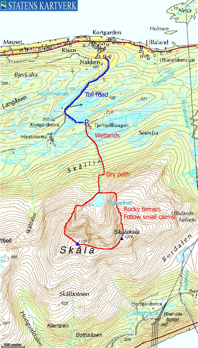
Follow the Kleive road 12Km to the place Kortgarden and turn right onto a narrow road when you see a bus-stop on the left-hand side, with the sign "Grendahus". Follow the road 900m upwards, then turn right. Pay fee at a self-served toll booth (NOK 20,- for passenger cars per Aug 2006). After 1,7Km (from the junction, not the toll), the road forks. Turn left and drive 500m. You see a forest trail forking off on the right-hand side of the road. Park on the left-hand side of the road (room for 2 cars) or find parking further ahead. Note that cars with very low clearance should be careful on the 500m road.
The route
From the parking/trailhead, follow the forest trail (unmarked) in the direction of the mountain. Cross a creek on a bridge (in poor shape per Aug 2006) before continuing on a vague path across boggy terrain just left of the forest and the river. From the point you enter the forest, and up to Lake Trollvatnet, the path runs mostly on dry ground and is easy to follow.
At the lake, turn left and follow a visible path that runs up a somewhat steep hill towards Skåaksla's south ridge. You have to cross a couple of short boulder sections. Once on the ridge, stay close to the cliffs above the lake, and follow cairns across rocky terrain up to Skålaksla summit, marked by a distinct cairn.
Proceed along the edge towards Skåla, and follow rocky terrain up to Skåla summit. On Skåla, you will find two large cairns, and their elevation should be about the same.
Upon descent, head northwest until you reach the edge of the plateau. Follow a path (gradually more and more visible the lower you get) down to Lake Trollvatnet and resume your ascent route.
If the mountain is fogged in, it may be wise to head northbound to the edge of the plateau, and follow the edge down. The fog in the bowl above Trollvatnet will most likely have a different shade of grey and should be easy to use for navigation.
 westcoastpeaks.com
Other Møre & Romsdal mountains
Other Norwegian mountains
westcoastpeaks.com
Other Møre & Romsdal mountains
Other Norwegian mountains

