
|

Nakken is the 5th lowest independent top in Rauma kommune (municipality). It is located by the Hjelvikbukta bay in Romsdalsfjorden, near the Rauma/Vestnes border. Despite the low mountain height, you still have good views across Romsdalsfjorden and the many peaks beyond.
A marked forest path runs from Vikåsen, 180m elevation. This trailhead is only 350m east of the Trolltinden trailhead.


Nakken (Norge 1:50,000: 436m, Økonomisk Kartverk: 435,63m, UTM 32 V 410571 6943014) has a primary factor of 268m, towards the higher parent mountain Trolltinden (1241m). The saddle (approx. UTM 32 V 410022 6941831) is found on Vikåsen, between Nakken and Storhaugen (745m). Ref. Økonomisk Kartverk (5m contours), the saddle height is within the range 165-170m, interpolated to 168m.
Google's interactive map. You can zoom, pan and click on the markers.
Notes: Class ratings are in reference to YDS. Click here for more information.
The trails described below are not necessarily the *easiest* trails to this mountain.
|
Vikåsen - Nakken (summer/autumn)
|
|
Access
(all distances are approx. distances)
From Ålesund, follow highway E136->E39 eastbound towards Åndalsnes. You pass the place Sjøholt, drive across Ørskogfjellet, down Skorgedalen valley to the Molde/Åndalsnes junction just before you reach Tresfjorden. Turn right towards Åndalsnes, drive around the Tresfjorden bay, pass the northern tip of the peninsula and drive to the Hjelvika bay. Turn right onto a smaller road runs on the south side of Nakken. This is 25Km from the E39/E136 junction in Skorgedalen.
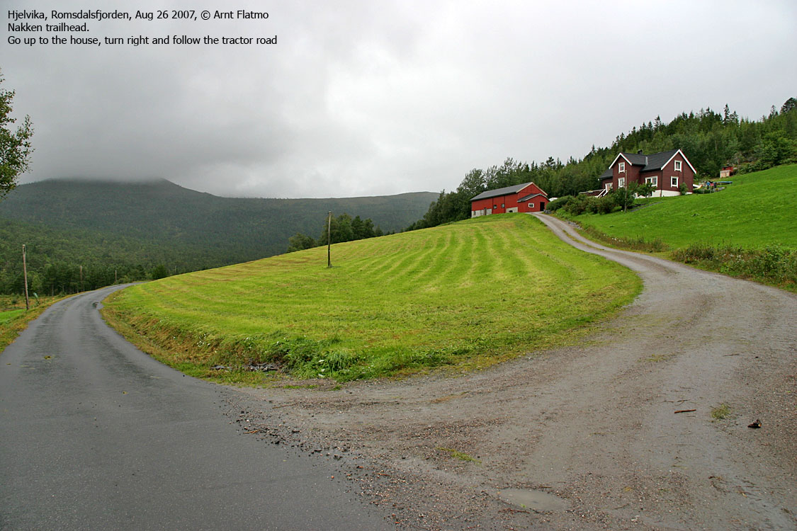
Drive 2Km and locate a farm up to your left. Find parking nearby.
The route
Head up the farm. At the house, turn right and follow a tractor road upwards. The tractor road turns into a path that runs along the farm fence. At the end of the farm field, go through a gate and follow the marked (red paint on trees) path up Nakken's south ridge. The path merges with another tractor road, but this tractor road doesn't run all the way to the top. Stick to the marking. Nakken summit is marked by a trigonometric point.
Note that the marking ends just before the summit. Make a note of where the last mark is. It will ease your descent.


No Javascript:
 westcoastpeaks.com
Other Møre & Romsdal mountains
Other Norwegian mountains
westcoastpeaks.com
Other Møre & Romsdal mountains
Other Norwegian mountains

