Norwegian Mountains, Møre og RomsdalStorhornet, 1600m
|
| Fylke/Kommune : | Møre og Romsdal/Ørsta | ||||||
| Maps : | 1219-III Hjørundfjord (Statens Kartverk, Norge 1:50 000) | ||||||
| Primary factor : |
Storhornet: 830m Blåbredhornet: 94m |
||||||
| Hiked : | June 2010 | ||||||
| See also : |
| ||||||
| See also : | Other Ørsta mountains |

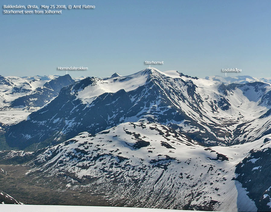
Storhornet is the 3rd highest mountain top in Ørsta municipality, only preceded by Kvitegga (1707m) and Store Smørskredtind (1631m), and is located between Storfjorden / Hjørundfjorden and Hornindal. The Storhornet massif has a number of satellite tops where Blåbredhornet (1364m), Bjørkehornet (1430m) and Rokkekjerringa (1543m) are some of the most well-known.
Storhornet is an excellent mountain for spring skiing. The toll road up Hjortedalen (Hornindal side) takes you up to 590m, leaving you "only" with 1000 vertical meters to go. There are also other routes to Storhornet, but this is the route described on this page. Another popular route runs from Raudstad and up Lauvadalen.
The views are quite phenomenal. You can see almost all of the significant Sunnmørealps from here, in addition to other landmarks such as the Hurrungane peaks and the Jostedalsbreen, Ramnefjellbreen, Myklebustbreen, Ålfotbreen and Gjegnalundsbreen glaciers.

Storhornet (Norge 1:50,000: 1600m, Økonomisk Kartverk: -, UTM 32 V 372892 6884875) has a primary factor of 830m towards the higher parent Kvitegga (1707m). The defining saddle (approx. UTM 32 V 376836 6883674) is found between between Tussa and Tusseholten. Ref. Norge 1:50,000 (20m contours), the saddle is within the range 760-780m, interpolated to 770m.
GPS measurement read 1606m (on the ground - on snow), averaged over a 5-minute period (error margin +/- 1,2m)
Blåbredhornet (Norge 1:50,000: 1364m, Økonomisk Kartverk: -, UTM 32 V 372524 6882527) has a primary factor of 94m towards Storhornet. The defining saddle (approx. UTM 32 V 373228 6883303) is found on Blåbreden glacier. Ref. Norge 1:50,000 (20m contours), the saddle is within the range 1260-1280m, interpolated to 1270m.
GPS measurement read 1365m (on the cairn - 150cm), averaged over a 5-minute period (error margin +/- 1m).

Google's interactive map. You can zoom, pan and click on the markers.
|
|
|
|
Route 1: Hjortedalen - Storhornet (spring - on skis)
|
|
This route description is valid per June
2010
Access
(all distances are approx. distances)
The starting point is Grodås/Hornindal by Lake Hornindalsvatnet. Follow highway RV60 approx. 5,7km to the east - in the direction of Hellesylt and Stranda. Turn left towards Engebø (signposted - UTM 32 V 372975 6876257) and drive 1km up to Engebø where you pay toll (UTM 32 V 372911 6876759).
Continue on gravel road 1,9km up to Hjortedalssætra. Turn right in a fork (UTM 32 V 373320 6878370) and drive 1km. Find parking (2-3 cars) on the left-hand side of the road (UTM 32 V 373908 6879061). The road continues up the valley, but this is the best place to start.
The route

Head towards Blåbreddalen valley and stay east of the river in Blåbreddalen. You will need to cross a river before you get into the Blåbreddalen, and while this river is normally easy to cross - snowmelt and heavy rain can quickly transform it into a larger river.
The route up the valley is quite obvious. You arrive on the Blåbreden glacier at approx. 1100m and soon you will see the only route up to Storhornet (see the below picture). Be aware of avalanches as you pass point 1575m. On hard snow, and in case of a fall, you can risk a longer slide where the Lauvadalen route meets Blåbreden.
Per June 2010, no cairn could be seen on Storhornet summit.

The route from Blåbreden to Storhornet

(Click for larger image)
 westcoastpeaks.com
 Other Møre & Romsdal mountains
 Other Norwegian mountains