
|

The mountains seen from highway 48(No Javascript) |
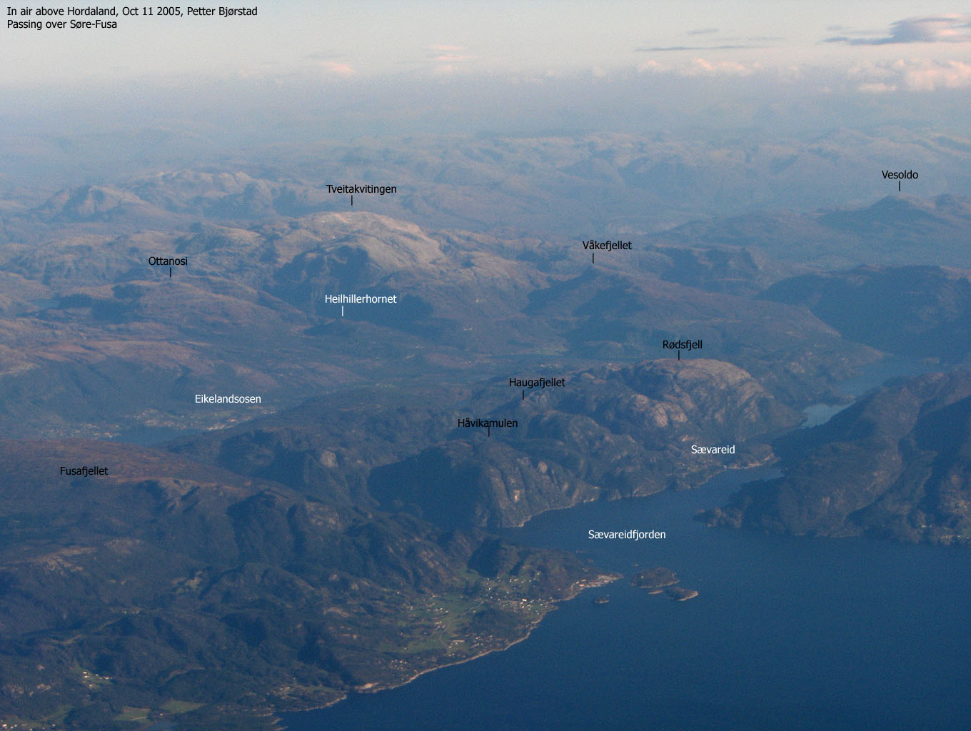
The round-trip across Ottanosi, Kjerringafjellet and Heilhillerhornet is one of Fusa's finest walks. Ottanosi is the main mountain. Kjerringafjellet is more or less a spur on the mountain, while Heilhillerhornet falls in the shadow due to the modest height. The views from Ottanosi are grand, even if the higher mountain range that runs from Kvamskogen to Gjøn blocks the east/northeast view.
Some believe that the name Ottanosi (also known as Ottanoso) means "Åtta noso" - eight noses. Apparently, one can see eight noses on this mountain, most likely formed by the many cliffbands that are characteristic for this mountain. Others believe the name originates from where the sun is seen in the morning (otta). The cliffbands and many steep hillsides limit the number of access routes to Ottanosi and Kjerringafjellet. There are indeed a few routes, but the general access point is from the south - near lake Vengsvatnet. Earlier, the trail to Ottanosi began at 110m elevation. Thanks to a brand new forest road, one can drive up to 340m elevation, and save at least 1,3Km on foot compared to the forest trail.
The new forest road has some interesting curves at the end of the road. The Hålandsdalen region has fostered many good skiers, including Liv Grete Skjelbreid-Poiree, multiple World Champion in biathlon. It is perhaps not a coincidence that when viewed from above, the upper part of the forest road resemble perfect slopes for cross-country skiing.
None of the mountains are difficult to reach, although I'm a bit puzzled about one spot on the Ottanosi trail. See the route description for more info around this. On all three summits, you will find a mailbox with a summit register.
Ottanosi (M711: 976m, Ø.K: 976,17m) has a primary factor of 343m towards the higher Bjørnakultane (1152m). The saddle is found N of lake Spongatjørni. Ref. Økonomisk Kartverk (5m contours), you cross the 635m contours on the high route, but not 630m. The saddle height has been interpolated to 633m.
Kjeringafjellet (M711: 938m, Ø.K: 942m) has a primary factor of 54m towards the higher Ottanosi (976m). The saddle is found between the two tops. Ref. Økonomisk Kartverk (5m contours), you cross the 890m contours on the high route, but not 885m. The saddle height has been interpolated to 888m.
Heilhillerhornet (M711: 558m, Ø.K: 557,53m) has a primary factor of 105m towards the higher Kjerringafjellet (942m). The saddle is found between the two tops, S of Belgen. Ref. Økonomisk Kartverk (5m contours), you cross the 455m contours on the high route, but not 450m. The saddle height has been interpolated to 453m.
Notes: Class ratings are in reference to YDS. Click here for more information.
The trails described below are not necessarily the *easiest* trails to this mountain.
|
Solvang - all summits round-trip (summer)
|
|
From Bergen, follow highway E16 towards Oslo. At the highway E16/7 junction in the Trengereid roundabout, turn right onto highway 7. Drive down to Samnangerfjorden, Pass Bjørkheim and two tunnels before you turn right onto highway 48 (Rosendal/Tysse). Follow highway 48 30Km and turn left towards "Tveita/Ø. Hålandsdal". Drive 400m and exit left towards "Hammersland". Follow this road for approx 2,1Km. Notice the "Botnavatnet" trailsign to your right. You have a few houses to your left. Park here if you want to hike the forest trail.
Or; continue 150m and pay fee for the forest road. Per July 2004, the fee was NOK 30,- for passenger cars. Follow the forest road for additional 2,4Km and park at the road end. The forest road continues, but only for those with special privileges.
Ottanosi
Follow the gravel road until you reach a gate (approx. 300m from the parking). Locate a trail that begins after the gate, on your left. Follow this trail down to the river. Alternatively, follow the forest road until you reach the lowest point and take a shortcut down to the river.
If you choose to hike from the old trailhead down by Solvang; The trail begins by the "Botnavatnet" trailsign. After 10 minutes, the trail disappears as you enter nature trail. Follow what appears to be a logical path, in the direction of - but not to - the mast you see up to your right. If you found the right trail, you pass a small waterfall when the trail is visible again. Go left. Soon you will arrive at a trail junction. Follow sign to "Botnavatnet". You are heading northwest - around Heilhillerhornet. Pass stone ruins, and when you reach a gate, head northwest down to the river.
Both trails: Cross the river via a bridge. Just after the bridge, you will see the "Botnavatnet/Ottanosi" trailsign. Go right. The trail climbs up through forest and the trail can be quite wet and boggy. At 410m. elevation you reach a cabin. Pass the cabin on the left hand side. The trail continues just after the cabin. The forest is now birch, and less boggy. The trail is now considerable steeper. Out of the forest, you see the characteristic cliffbands. The route to the summit is well marked by small cairns (standing rocks).
At approx. 730m elevation you reach a cliffband that defines the Ottanosi route to class 2. The route up the cliffband is quite obvious, but near the top you must either scramble a V-shaped rock or bypass this rock trading difficulty with exposure. Most people will be able to go up here without big problems, but when the cliff is icy, show considerable caution if you take the exposed route.
After this cliffband, you will see the summit, and the route upwards is steep, but trivial. The summit is marked by a proper cairn and a mailbox. A smaller cairn, just north of the summit cairn marks a viewpoint towards lake Botnavatnet and the mountains beyond.
Kjerringafjell
Kjerringafjell is only 1,2Km northeast of Ottanosi in a direct line, but the hike is somewhat longer (2Km). From Ottanosi, proceed northeast until you reach the saddle between the two mountains. Head up Kjerringafjellet and proceed southeast until you reach the 938m high point, defined by a mailbox on a pole (no cairn). Easy terrain, although there is a lot of ups and downs. Find a good route inbetween the humps.
Heilhillerhornet
From Heilhillerhornet, proceed southwest, but seek gradually left on the ridge and you will see cairns that will guide you down the first cliffband. Once down from the cliffband, a valley forks off to your right. You will see cairns down the upper section of the valley. I might have misunderstood these cairns, thinking the public route bypassed the ridge towards Belgen. I stuck with the high ridge, entering class 2+ terrain. Once past the initial obstacles, I regained the cairn trail. This leads me to believe that the public route follows the valley for a short while, then turns back on the main ridge via a broad ledge further down.
Another major cliffband must be passed. Again, the cairn trail runs on the left hand side of the ridge (as you look down). In the saddle between Heilhillerhornet and Kjerringafjellet, one trail runs east of Heilhillerhornet, and another runs down west towards the forest road. Follow the trail that pass Heilhillerhornet, and leave the trail as it starts to descend. The short hike up to the summit is off-trail. The Heilhillerhornet summit is defined by a mailbox on a pole. Head back down to the trail, back to the saddle and follow the trail down to the forest road.
Note: According to information I got in September 2014, the route is now properly marked.


Ottanosi was already "in the bag" back in 2001, but I later discovered that Heilhillerhornet should also be considered an independent mountain. I never considered Kjerringafjellet anything more than a spur of Ottanosi, but as I was heading towards Heilhillerhornet this Sunday, I decided to try a round-trip, including all three summits.
The weather was better than I had expected. The high summits were holding on to the clouds, and as I had thought, Gjønakvitingen was hidden in clouds, while Ottanosi was almost cloud-free. A friend had told me about the new forest road, and I was quite happy to save a kilometer or two by driving to the road end. After all, I had done the forest route already.
Troll was unwilling to struggle on the wet and boggy trail. I didn't mind carrying him. I moved faster then. We had left the trailhead 13:40PM and made steady progress up the mountain. As we were out of the forest, we became the attention of a flock of sheep, more hungry for salt than you could imagine. With the quick pace up the hillsides, I had plenty of natural salt, and I was afraid they would start licking the dog as well. After numerous "whoooos" and rapid arm movements, the flock gave up after a while.
We reached Ottanosi summit 15:05PM and the summit was cloud-free. Clouds were still hiding the Gjønakvitingen summits, but that didn't matter much. I wasn't going there. After a short break for lunch, I signed the summit register put in place by Hålandsdalen IL and continued towards Kjerringafjell. We reached Kjerringafjell summit 15:45PM.
I was very excited about descending the ridge. I had studied the cliffbands while ascending Ottanosi, and if I hadn't already been told that there were cairns down the ridge, I might never have attempted this route. Initially, there were no cairns, which was a surprise. I continued down the ridge for a while, and eventually found cairns that guided me down the first cliffband. After this cliffband, a valley forked down to my right, and I saw cairns there. I wondered if the normal route headed down the valley. I decided to take my chances with the ridge. Soon I ran into quite cumbersome terrain. A few cliffbands had to be downclimbed and it wasn't straightforward. Below these cliffbands, the cairn trail appeared again. I assumed the cairn trail had bypassed these cliffbands via a ledge down to my right.
I was the first visitor on Ottanosi for 5 days, but two people had already been on Kjerringafjellet earlier this Sunday. I caught up with these two on my way down. They were heading down to the forest road while we continued up to Heilhillerhornet. Troll had been walking off and on above the forest below Ottanosi, and had done but I put him in the backpack when I was going off-trail towards Heilhillerhornet summit. We reached the summit 16:20PM. The summit mailbox looked very old, but I found a fairly new summit register here as well. These mountains are popular. Instead of hiking back to the Kjerringafjell-Heilhillerhornet saddle, I decided to try my luck down the steep forest below Heilhillerhornet. That turned out quite OK, and I ended up near the bridge that connects the trail to the forest road.
On my way down the forest road, I ran into Erling Solvang, who gave me a long story about the home restistance movement during World War II. The story took a good 30 minutes, but it was fascinating to learn about how they organized cargo drops from RAF without being spotted by the Germans. More wise than ever, I was back at the car 17:45PM. I looked back towards the mountains. The clouds had lifted from the Gjønakvitingen massif while I was descending the ridge from Kjerringafjell. Now, the clouds were back on Gjønakvitingen as well as on Ottanosi. I was given a timely window and had an excellent hike across some of Fusa's finest mountains. I strongly recommend this hike to everyone.
Move cursor to read notes, and click on the images to see full version.
Some of the thumbnails may have been cropped to fit the format.


No Javascript:
1 2 3 4 5 1 6 7 8 9 10 11 12 13 14 15 16 17 18 19 20 21 22 23 24 25 26 27 28 29 30 31 32 33 34 35 36 37 38 39 40 41 42


No Javascript:
1 2 3 4 5 6 7 8 9 10 11 12 13 14 15 16 17 18
Other hordaland mountains
 Other Fusa K. mountains
westcoastpeaks.com
Other Fusa K. mountains
westcoastpeaks.com

