
Norwegian Mountains, Møre og Romsdal
|
| Fylke/Kommune : | Møre og Romsdal/Herøy | ||||||
| Maps : | 1119-IV Fosnavåg (Statens Kartverk, Norge 1:50 000) | ||||||
| Primary factor : | Remøyfjellet: 188m | ||||||
| Hiked : | July 2008 | ||||||
| See also : |
| ||||||
| See also : | Other Herøy mountains |

Remøy/Rimøy
(Click for larger image)
Remøy/Remøya/Rimøy/Rimøya is a coastal island, neighbouring to other Herøy islands such as Nerlandsøya, Bergsøya, Leinøya and Runde. The many variations of the name are a bit unfortunate, and previous pictures on this site are not referring to a consistent name of the island.
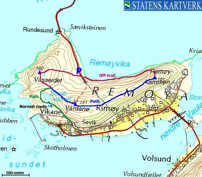
The "summit" area has two points. On Norge 1:50,000, the northernmost point (named Sævikhatten on Økonomisk Kartverk) is 191m, while the southernmost point has a trigonometric point and is 188,28m on Økonomisk Kartverk. The summit area is called Vardane (the cairns) on the 1:50,000 map, suggesting there are a number of cairns on top (like on Sulafjellet). The plural form is however misleading. Upon visit, the two points seemed equally high, but 188m will be used as the official height on this site. Furthermore, this site introduces the name Remøyfjellet, which, although not being an official name is more precise than Vardane.
Vasseidet is the westernmost point on this island, and Rimøykammen is the easternmost. This page will describe a round trip across all of these points.
What is undisputable is that you get some nices views from the top. The Ytre Søre Sunnmøre coastal region is a beautiful one, with Ørsta and Volda peaks as a formidable background.

The Runde-Remøy bridge
(Click for larger image)
Remøyfjellet (Norge 1:50,000: -, Økonomisk Kartverk (ØK): 188,28m, UTM 32 V 325973 6919456) has a primary factor of 188m, being the high point on the island.
GPS measurement (on the ground) read 190m on the ground (error margin +/- 5,1m). This is the southernmost of the two summit points (not the one with the building)
Vasseidet (Norge 1:50,000: 162m, Økonomisk Kartverk (ØK): 162,07m, UTM 32 V 325296 6920055) has a primary factor of 69m towards the island high point. The defining saddle (approx. UTM 32 V 325526 6919807) is found between the two tops. Ref. Økonomisk Kartverk (5m contours), the saddle is within the range 90-95m, interpolated to 93m.
GPS measurement (on the ground) read 163m on the ground (error margin +/- 2,2m)
Rimøykammen (Norge 1:50,000: -, Økonomisk Kartverk (ØK): 184,08m, UTM 32 V 327382 6919961) has a primary factor of 41m towards the island high point. The defining saddle (approx. UTM 32 V 326464 6919476) is found between the two tops. Ref. Økonomisk Kartverk (5m contours), the saddle is within the range 140-145m, interpolated to 143m.
GPS measurement (on the ground) read 190m on top of the cairn (error margin +/- 4,9m). The Norge 1:50,000 181m (180,56m) point is a trignometric point 39m northeast of the cairn that marks the high point.
Google's interactive map. You can zoom, pan and click on the markers.
|
|
|
Notes: Class ratings are in reference to YDS. Click here for more information.
The trails described below are not necessarily the *easiest* trails to this mountain.
|
Route 1: Vardane from Sævik (summer)
|
|
Access
(all distances are approx. distances)
The nearest larger city is Ålesund. From Ålesund, follow highway E39 towards Bergen, and then RV61 towards Hareid. Take the Sulesund - Hareid ferry and follow RV61 (roughly) 3Km towards Ulsteinvik. At the roundabout junction outside Ulsteinvik, turn left and follow RV61 southbound and turn right when you see the "Måløy" sign. Once on Gurskøya island, follow highway RV564 in the direction of Fosnavåg.
At the Remøy/Runde junction on Bergsøya (before Fosnavåg), turn right. Drive 6,8Km (pass through Leinøya island) and turn right towards Sævik (signed). Follow this road 250m upwards. The road forks. Turn right. Locate the path by the upper house. You will need to find parking further down, unless you ask for permission to park.
The route
Note! Route information is based only on observations and assumptions.
A well worn path begins by the uppermost house and heads for Storevatnet. The path passes Storevatnet on the west side, continues up the Vasseidet - Vardane saddle and then towards Vardane.
|
Route 2: Remøy round trip (summer)
|
|
Access
(all distances are approx. distances)
The nearest larger city is Ålesund. From Ålesund, follow highway E39 towards Bergen, and then RV61 towards Hareid. Take the Sulesund - Hareid ferry and follow RV61 (roughly) 3Km towards Ulsteinvik. At the roundabout junction outside Ulsteinvik, turn left and follow RV61 southbound and turn right when you see the "Måløy" sign. Once on Gurskøya island, follow highway RV564 in the direction of Fosnavåg.
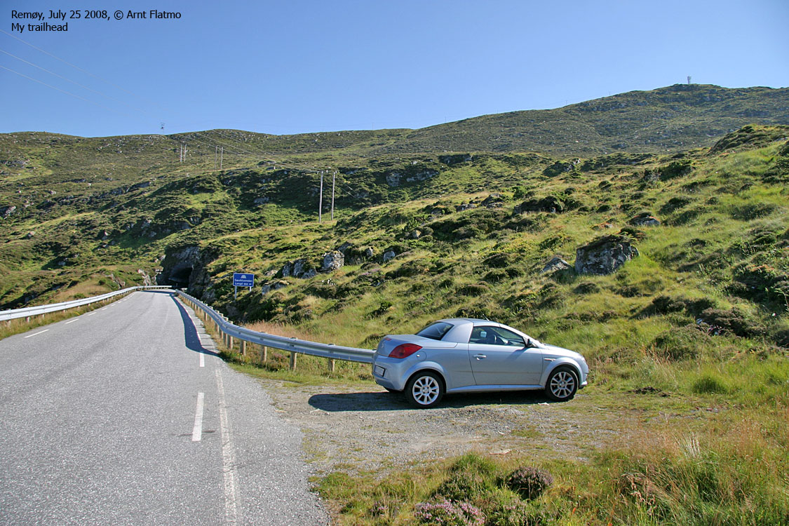
At the Remøy/Runde junction on Bergsøya, turn right. Drive 8,4Km (pass through Leinøya island). You've now just gone through the tunnel and you'll find parking on your left-hand side, 150m after the tunnel.
The route

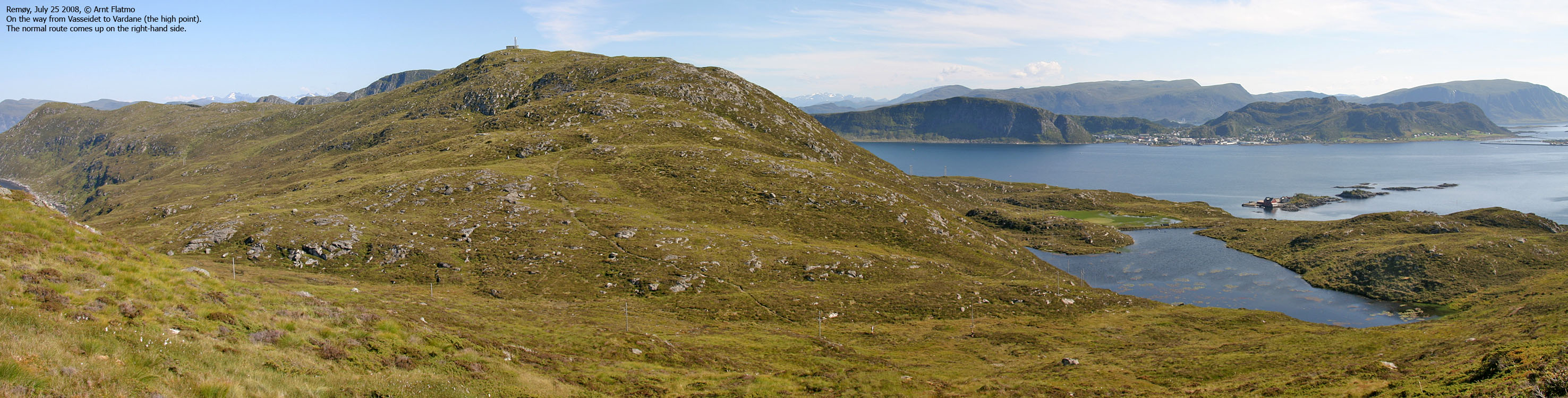
Parts of the route
(Click for larger image)
From the parking, head westbound towards Vasseidet. There is no path, just turfs. The direction is obvious, just head upwards. Vasseidet has several humps in the summit area. The high point (N62.37081 E5.62228) has no cairn, but you will find a small bolt.
Proceed towards Vardane. You will join the well worn path from Sævik in the saddle between the two tops. Just before the top, the path forks. One path leads to the building/antenna, and one leads to the trig. point.
Continue northeast on path towards Rimøykammen. You'll pass a cairn (the high point) before reaching the trig. point. You may now continue the descent in the northeast direction to the tip of the island, or descend northbound and locate a gully that will take you down the steep drop towards the shore.
Follow the shore back to the trailhead on easy boulder.
 westcoastpeaks.com
Other Møre & Romsdal mountains
Other Norwegian mountains
westcoastpeaks.com
Other Møre & Romsdal mountains
Other Norwegian mountains


