
|


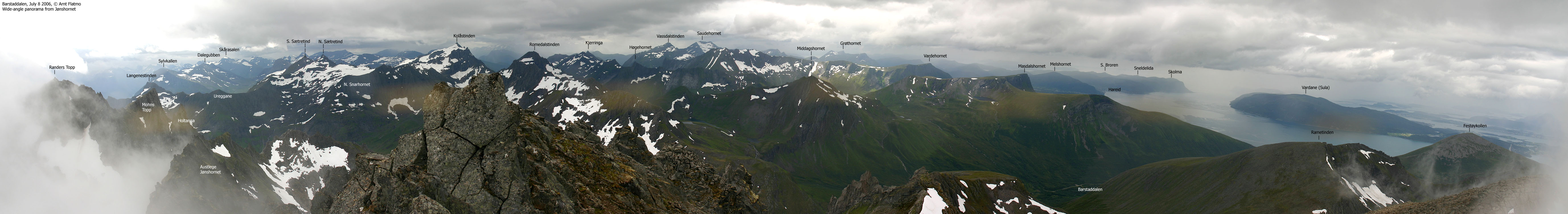
Kolåtinden, Romedalstinden and Middagshornet form the eastern side of the beautiful Romedalen valley. Along with Årskogdalen valley, Romedalen was a trade route between Vartdal (Nordre and Søre) and Standalen. From the Årskogdalen - Romedalen pass, one could also reach Ørsta through the Ørstaskaret pass.
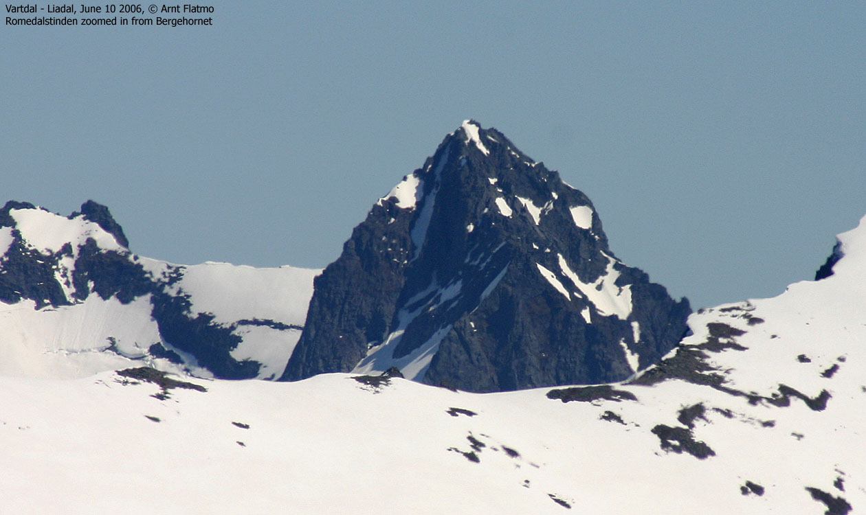
Romedalstinden is a magnificent peak, but will always suffer from comparison to the even more splendid neighbour - Kolåstinden. The booklet Rock Climbs in Sunnmøre (Prag, 1953) says about Romedalshorn: "A typical Sunnmøre peak with very narrow and jagged ridges". In the same booklet, Kolåstinden is referred to as "a grand peak....".
There are several ways to get to Romedalstinden, but this page will descibe the route from Ytre-Standal, possibly the most frequently used route nowadays. You can reach its front-top (3-6m lower) without any other difficulties than a long walk and a tough hill. An exposed and airy summit ridge calls for a head for heights, if you want to reach the high point. Some manage, through some scrambling, to find their way below the summit ridge.
Randers' book Sunnmøre, mentions routes from Steinstøylen (northeast ridge) and Romedalsskaret (south ridge), but not the route from Ytre-Standal. The Ytre-Standal route is however properly described in the book Fotturar på Sunnmøre (Standal/Hagen/Wangen). Randers' book also notes that the mountain is/was also known as Ronddalsstøyltind and Romedalshorn.
Romedalstinden connects southbound to Kolåstinden through Romedalsskaret pass, northwestbound to Hallehornet-Middagshornet through Steinstøylsskaret pass and northeastbound to Storkopptindane. Storkopptindane in turn connects to Molladalstindane via Svinetinden S and Grønetinden, and voila, an amazingly wild and unfriendly mountain ridge, stretching from Barstadvika in the north to Standalen in the south.


Climbing history
Romedalstinden was ascended via the north ridge by E.V. Mather, C.W. Patchell and J. Simpson, Sep 4 1894. They started out from Lille Standal and headed up to the "skar" on the north ridge. If Lille Standal is the same as Ytre-Standal, then the "skar" may possibly the saddle between Romedalstinden and Storkopptindane, thus the route described on this page. The source also states that "The skar can also be reached from Store Standal via Kolås and Steinstøl seter".
Ascent via the west ridge was done by H.C. Bowen and C.W. Patchell, Aug 15 1903. The source says: "Cross the snowfield from the head of Romedal skar to the col at the foot of the W. ridge, which follow to the cairn. This route is easier than by the N. ridge".
Source: Rock Climbs in Sunnmøre Norway, Prag, 1953.


Romedalstinden (Norge 1:50,000: 1295m, Økonomisk Kartverk: -, UTM 32 V 360152 6908653) has a primary factor of 325m towards the higher parent mountain Kolåstinden (1432m). The defining saddle is Romedalsskaret (approx. UTM 32 V 360179 6907377). Ref. Norge 1:50,000 (20m contours), the saddle is within the range 960-980m, interpolated to 970m.
Personal GPS measurement averaged the elevation to 1300m, over a 10-minute period. The GPS was located on top of the cairn, which is perhaps 50-70cm high. The front-top (which elevation is unknown) was averaged to 1294m over a 5-minute period. The GPS accuracy was reported to 1m. These are just observations, and not claims that Romedalstinden's official height is wrong.

Notes: Class ratings are in reference to YDS. Click here for more information.
The trails described below are not necessarily the *easiest* trails to this mountain.
|
Ytre-Standal - Romedalstinden (summer/autumn)
|
|
Access
From Ålesund, follow highway E39 towards Bergen/Volda to the ferry at Solavågen. Take the ferry over to Festøya. Turn left in the direction of Standal and follow the road 10,4Km to Ytre-Standal. Turn right onto an unsigned gravel road (toll) in a left curve. Follow this road to its road end at approx. 200m elevation (1,9Km)
This road is (probably) only plowed up to the nearest houses in winter.
The route
From the parking, follow a well-worn path up to the Ytre-Standalsætra cabins, located on a hill with a fine view towards Hjørundfjorden. Follow the Molladalen/Standalshytta path (trailsign) approx. 230m westbound, where the path forks. The trailsign was broken in July 2006. Go left, and follow a visible, but narrow path towards Litlekoppvatnet. You will cross a river on a bridge 50m after the trailfork.
At 640m elevation, or 500m before you reach Lake Litlekoppvatnet, it is time to leave the path (which continues towards Standalen), turn right and head up a tough hill. Follow grass, or the faint path whenever you see it. There is a massive slab area to your left, but you don't see it until you gain some ground. Higher up, seek towards the mountainside on your right, not only to avoid cumbersome scree, but to stay protected from rockfall, caused by hikers above you. As the mountainside gradually curves to the left, chances are that runaway rocks will seek towards the ditches leading into the massive slab area, thus keeping you away from the immediate danger. But remember, rocks can change direction, so be advised.
On your way upwards, you pass two distinct "horns". Don't ascend up the ridge on the right-hand side of these "horns". Maintain your course in the hillside and top out at the Storkopptindane - Romedalstinden col (saddle). Follow the ridge towards a distinct pinnacle, which you pass on the right-hand (north) side. The ledge you pass on, is located fairly high and should be obvious. Top out on the ridge and descend on the other side. A faint path will lead you up to the left of the steep, rising wall.
Overall, the route up to the front-top is easy, but a few places require more attention than others. There are at least two places where a stumble can be fatal. A short, but distinct and very exposed slab-rock can either be passed by holding on to the rock above, or you can scramble directly up to the right.
The ridge narrows up to the front top, but broadens on the other side. A 30m, narrow and very airy ridge connects the front-top to the summit. Some manage to scramble their way down and below this ridge, but on dry rock, the summit ridge is fairly easy (YDS 2+), in terms of scrambling. Once down on the summit ridge, a slanting, large, slate-looking rock should be crossed by holding onto its edge (quite obvious when you get there). Then, an easier section follows, where you can either stay on the ridge-crest or bypass some of the rocks, on the side. Finally, a short, 40-50cm wide and incredibly exposed "bridge" connects to the summit block. With head for heights, you can easily walk upright, but don't mess up when you get down from the ridge. The summit is marked by a modest cairn (fair enough, given the space). What-used-to-be a trigonometric point can be seen in the northern mountainside, just below the summit.
Giving this route a YDS classification, wasn't all that easy. The overall route from the Romedalstinden - Storkopptindane col, is 2+. But the (short) descent from the front-top, and down to the summit ridge (and likewise - back up again) is, a short class 3 point. The exposure has not been taken into consideration here, just the ease of movement.

 westcoastpeaks.com
Other Møre & Romsdal mountains
Other Norwegian mountains
westcoastpeaks.com
Other Møre & Romsdal mountains
Other Norwegian mountains

