
For Information, maps, trailhead and route descriptions, click HERE.
The gorgeous weather should warrant a somewhat bigger project than Røyrafjellet, but my Høgåsen (Dimna high point) pictures weren't all that great, and I felt that this island deserved some pictures on a sunny afternoon. This was such an afternoon. Besides, I wanted to get to the bottom of my Hareid and Ulstein to-do lists, and moreover, a hard ski-trip was coming up the day after.
It didn't take long to locate the trailhead. By 15:05PM, my four-legged buddy Troll and I were on our way up the ridge. We passed point 121m (Økonomisk Kartverk), and my GPS read 117m. The high point (123m) further ahead, seemed considerable higher. The path was more or less icy from start to finish, and Troll had a series of challenges ahead of him.
We reached the top 15:35PM (after a 10 min. stop for pictures on point 121m) and my GPS read 124m. I was glad to see Troll walking, seemingly content. He was on a new drug - some medicine attempting to prevent dementia (he's been acting somewhat odd lately). Apparently this drug increases the blood circulation, "clearing up" his brain. But he was sleeping all day, like he never slept before, and I began wondering if the pharmacist had handed out wrong drugs. Perhaps I confused her, while joking about the medicine being for me. I explained to her, how I, while driving home for work, always managed to forget where I lived. As a precaution, I had my name and the phone number to the telephone directory on a piece of paper. That way I learned where I lived, and furthermore, I got driving instructions.
It took the pharmacist a little while before she noticed the vet sign at the bottom of the prescription. She wasn't laughing, so I guess my joke was "wasted". In retrospect, I figured that the pharmacy was not a good place for practical jokes. I wrote it down on my "Things to avoid" list, just after "don't wave hello to rescue helicopters".
After a short stay at the top, we headed back down. Arriving the ferry harbor in Hareid, was just as tormenting as expected. I arrived 16:10PM, and was -lucky- enough to get on a ferry one hour later. All 8 lanes were full, half an hour before the ferry arrived. The cars were probably stacked up Hareiddalen. I'd be more than happy to pay TWICE the ferry fee for a tunnel...
To Røyrafjellet


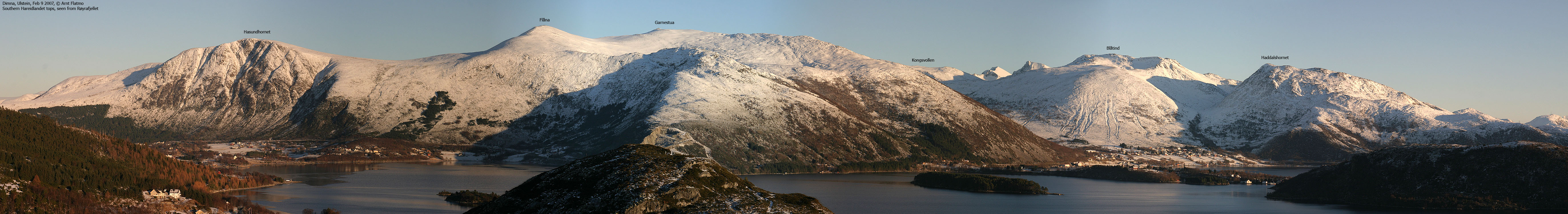
On Røyrafjellet


Hareid / ferry pics


No Javascript:
1 2 3 4 5 6 7 8 9 10 11 12 13 14 15 16 17 18
 westcoastpeaks.com
Other Møre & Romsdal mountains
Other Norwegian mountains
westcoastpeaks.com
Other Møre & Romsdal mountains
Other Norwegian mountains