
|


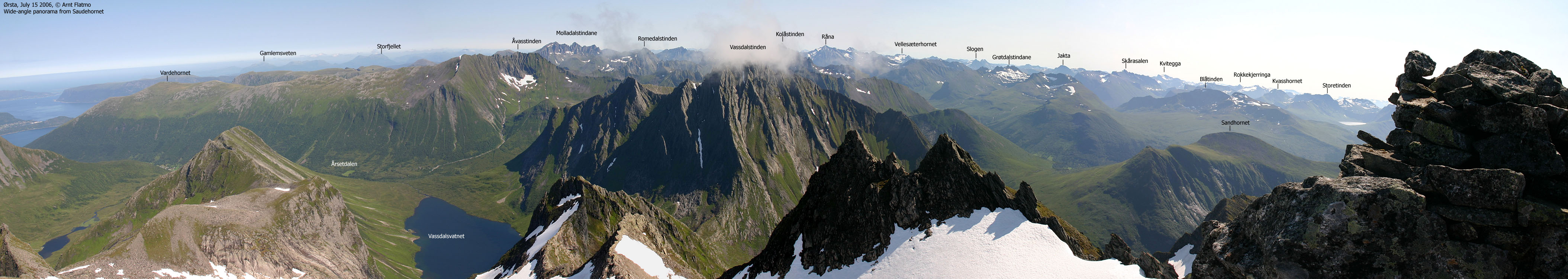
Sandhornet is an independent mountain, located above (northeast of) Ørsta. Sandhornet connects to the Kjerringa - Høgehornet - Sveddalstinden (etc.) ridge of sharp peaks, which in turn connects to Åvasstinden and drops down to Vartdalsfjorden. In addition to being one of the easiest (and most popular) skiing mountains in the Ørsta region, Sandhornet also offers superb views.
While it is possible to traverse this mountain (north-south, or vice versa), and also ascend via the Kråkenakken - Grøthornet ridge, this web page documents the most common route to the top - from Brudevollen. A forest road takes you from 100m to 320m elevation, where you enter open terrain. The ascent route is considered safe, but fog is dangerous due to the overhanging cornices facing east.
At the trailhead, you will find Brudevoll Gard, which offers cabins for rent. Various activities are offered, including horseback riding.
Sandhornet is well described in the book Skiturar i Sunnmørsalpane (Hagen/Standal)


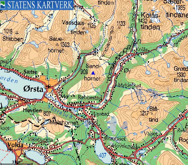
Sandhornet (Norge 1:50,000: 909m, Økonomisk Kartverk: 909m ??, UTM 32 V 354922 6900940) has a primary factor of 471m, towards the higher parent Årsæterhornet (1047m). The saddle (approx. UTM 32 V 355528 6902536) is found between Sandhornet and Rotbergshornet.. Ref. Økonomisk Kartverk (5m contours), the saddle is within the range 435-440m, interpolated to 438m.
Note:
On Økonomisk Kartverk, point 909m is not found ON the summit. It is located on the 890m contour. The problem is that the 895m contour is the highest, and as such, it is reasonable to assume that this map is wrong. Personal GPS measurement on the summit read 915m, but one has to take into account the snow depth and GPS error margin. 909m may be the correct height, but shown wrong on Økonomisk Kartverk.
Google's interactive map. You can zoom, pan and click on the markers.
Notes: Class ratings are in reference to YDS. Click here for more information.
The trails described below are not necessarily the *easiest* trails to this mountain.
|
Brudevollen - Sandhornet (spring, on skis)
|
|

Access
The starting point for this route description is Ørsta. Follow highway RV655 in the direction of Sæbø to the Follestaddalen / Sæbø junction. Drive straight ahead in the direction of Follestaddalen (don't turn right across the bridge) and continue 0,6km. Turn left towards Brudevoll (signposted). Drive another 0,6km up to Brudevoll. Locate a gravel road that runs north towards the cabin area. Either find parking near Brudevoll or along the road to the cabins.
The route
Follow the road towards the cabins, go through a gate, turn left (west) and follow the forest road 0,6km before you turn right at a fork. Follow this road for 1,5m in the east/northeast direction up to 340 meters elevation (go straight ahead in any forks along the way). When you have a clear mountain view, leave the forest road and head northeast up to the ridge between Rebbestadhornet (811m) and Sandhornet - and subsequently up to the summit (N62.21221 E6.21017). Be aware of overhanging cornices towards the east.
 westcoastpeaks.com
Other Møre & Romsdal mountains
Other Norwegian mountains
westcoastpeaks.com
Other Møre & Romsdal mountains
Other Norwegian mountains

