| County/Municipality:
| Møre og Romsdal county/Herøy municipality |
| Maps: |
1119-IV Fosnavåg (Statens Kartverk, Norge 1:50 000)
|
| Primary factor: |
431m |
| Hiked: |
June 2006, June 2012 |
| See also: |
|
| See also : |
Other Møre og Romsdal
mountains on westcoastpeaks.com |

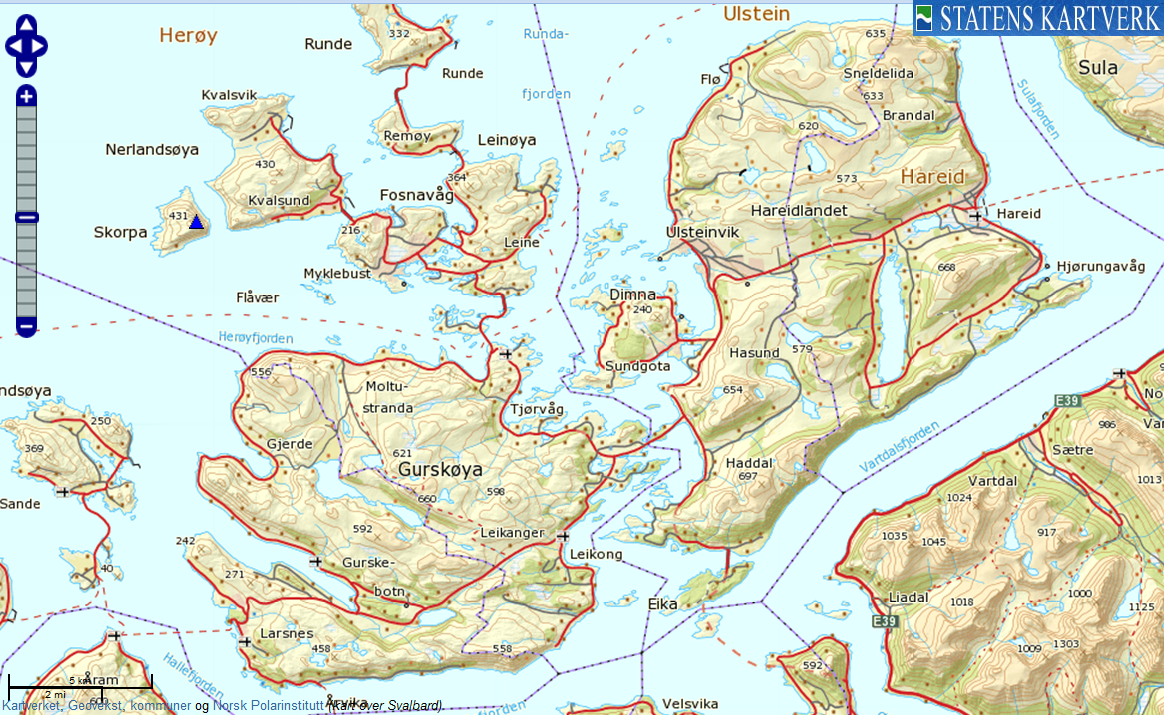
Keipen on Skorpa island

(Click for larger image)
Introduction
| Keipen (Skorpetua) on Skorpa island is located 37Km southwest of Ålesund, and is an uninhabited island.
Except for the colony of wild goats, they are quite a sight!
You can not
get there by car or public transport, only by private transportation in boat. The houses
on Skorpa,
on the south side of the island, are only habited in the summertime. Only wild
goats stay on the island, all year around.
Keipen is Herøy kommune's 4th highest mountain, preceeded by Sollia (660m), Rjåhornet (598m), Laupsnipa (558m),
all tops located on Gurskøya island. Keipen outranks Storevarden on Nerlandsøya by 1m. A (vague) path runs
from Skorpa harbor to the top.
From Keipen, you have a good view towards the island Svinøya, located 11Km west of Skorpetangen (the southernmost
point on Skorpa). The lighthouse is no longer staffed, but remains an attraction. Access by boat is difficult
because of the rough sea around the island.
The remaining views are quite remarkable. From this 431m high coastal mountain,
your view ranges from Løvsøya (northeast) to Stadlandet (southwest). In-between
is an "unbelievable" number of mountain tops...
Should you decide to visit Skorpa, contact
Herøy kommune to see if they are able
to foward you to someone who might know where to hire transport to the island. |
|
Skorpa was an important contact point for the
Shetland bus and for other allied military traffic
during the
Second World War. The island served as a station for
agents and resistance personnel both to meet and to
hide. Instructors, weapons, and sabotage material were
transported to the Norwegian resistance forces. For many
who departed to
Great Britain this was the last stop, just as it was
the first stop for many agents on the way into Norway.
In
1940 retreating
English soldiers were hidden here, before being
evacuated to
Shetland in fishing boats.
1941 was the first year that Norwegian boats covered
the route between Norway and Shetland.
Leif Larsen (popularly known as Shetland Larsen),
a famous Shetland Bus captain, was the first
captain on this route. On November 17,
1943 the
KNM Hitr, a converted U.S. submarine chaser, began
to cover the route, shortly joined by the
MS Bergholm.
Most allied activities on the northern coast lasted
only 7–8 months, but Skorpa operated throughout the war.
German soldiers made many house-to-house
inspections, but never found any illegal equipment such
as radios. A number of the residents were notably active
in the resistance, including Gerhard and Sina Skorpen,
who departed to England under the cover that they had
drowned. Gerhard afterwards became a crew member of
another converted U.S. submarine chaser, the
KNM Vigra, upon which Leif Larsen served as skipper.
At the close of the war they returned to Skorpa.
Copied from
wikipedia |
|

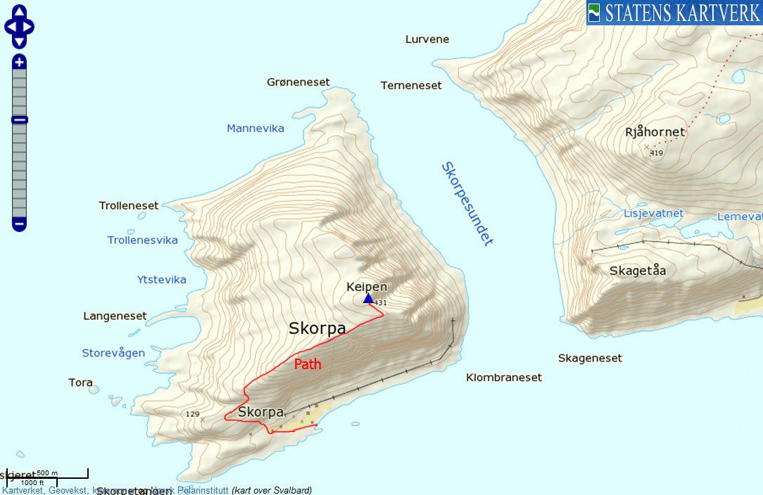
Skorpa
(Click for larger image)
Primary factor:
Keipen (Norge 1:50,000:
431m, Økonomisk Kartverk: 431,46m, UTM 32 V 318903 6915826)
has a primary factor of 431m,
being the high point on Skorpa island.

Keipen and Skorpa
(Click for larger image)
Google map
Google's interactive map. You can zoom, pan and click on the markers.
Trail descriptions
| This disclaimer is
regarding all of the literature and instructional guides posted on the
westcoastpeaks.com website.
These instructions are guidelines only, and should not be used in lieu
of common sense or judgment when attempting any of the actions involved
or instructed. Westcoastpeaks nor myself will not be liable nor will it
indemnify any form of compensation to anyone who has injured, harmed or
even killed themselves or others while following any of the instructions
written within the website.
It should be noted by any persons willing to undertake any of the
instructions provided that mountains offer varying levels of risk,
regardless of size or incline. Risks to be considered are as follows but
not limited to: wild animals, weather, the terrain, bad judgment,
inappropriate or insufficient equipment, improper training or experience
and of course, bad luck... |
|
Route 1: Skorpa (all seasons)
| Difficulty : |
YDS
Class 1 |
| Exposure : |
No |
| Distance : |
Approx. 2,4km to the top |
| Time : |
Approx. 1 hour to the top |
| Starting Elev.: |
Sea level |
| Vertical Gain : |
Approx. 450m (total) |
|
|
This route description is valid per June
2012
Access
There is no public transport or roads to this island. You will need to organize private transportation,
preferably someone who knows the correct route through shallow waters
outside Skorpa!
The route:

The route, as seen in Google Earth
(Click for larger image)
From Skorpa harbor, walk
past the houses and turn right onto a mountain path before you reach
the last house. Follow the path up to the ridge, then turn
northeast and go through a rocky area (use of hands might be
required...) before the path follows the ridge to the top of the island
- marked by a proper cairn (N62.32995 E5.50368).

Skorpa harbor
(Click for larger image)
Pictures and Trip reports:
 westcoastpeaks.com
Other Møre og Romsdal mountains
Other Norwegian mountains westcoastpeaks.com
Other Møre og Romsdal mountains
Other Norwegian mountains
|


