
For Information, maps, trailhead and route descriptions, click HERE.
Saksa would be my last top on this short Nordmøre weekend. I had just visited Freikollen on Frei island, and was now on my way to Saksa. First, I had to wait more than one hour for the ferry to Halsa, and then it began to hail. A phone call to a friend of mine, was comforting. She told me that the weather seemed to get get better during the afternoon. I put my faith in this forecast and waited patiently for the ferry.
The plan was to hike Saksa from Volem, via Varden. This was the route on my Nordmøre hiking map. I drove in the direction of Innreitan, and noticed two parking guards along the road. There was a soccer game going on, and I asked them for advice. They suggested that I'd drive all the way to Innreitan, and follow a forest road upwards. And so I did. At Innreitan, I met a some folks and decided I should double-check the information I got. When they learned that I was heading for Saksa, they pointed me in a STRANGE direction. After a while, the confusion was sorted out. Apparently, there was a cabin at - or in the direction towards Kvalnesvika, that ALSO was named Saksa. Hard to believe, but they all agreed. When they realized that I was heading for the mountain, they told me to drive back to a place where they stored timber, and follow the forest road from there. One of them told me, that when I saw the Innreitsætra cabin, I should NOT go up to the but, but rather go *down*.
With all this information in mind, the dog and I headed out 13:10PM. Troll was kind enough to walk for a little while, then he gave me the NO THANKS! position, and into the backpack he went. On this tour, I had carried him up to Melen. He was good enough to walk up to Sjurvarden. Then I carried him to the top of Mekknøken later that day (yesterday), and this morning I carried him to the top of Freikollen. Christ! I had to remind myself: He ain't heavy, he's my ..
After 25 minutes on the forest road, I ran into a road fork. I noticed a cabin further ahead on the road straight ahead. The road to the right went *downwards*. I remembered what the lady had told me, and decided to head downwards. It sort of made sense. I would now get on the west ridge, and find a path there. That never happened. I managed to stop my descent before ending down in Kvalnesvika. When I headed back up again, I noticed a vague path heading towards the west ridge, and (oddly enough in hindsight) I decided to follow this path.
It didn't take me long to realize that this path hadn't been traveled since World War II, but now that I was here, I should try to make the best of it. The west ridge wasn't bad. The birch forest was quite open, but then I ran into cliffs that forced me to stay left. I entered the ridge at 260m elevation, and joined the normal path at 510m elevation. I had wasted time and elevation, but it didn't matter at all, because the day was just outstanding. Sunshine and warm weather. The last 24 hours had offered fog, rainshowers and hailshowers. A slight detour in gorgeous weather didn't matter much.
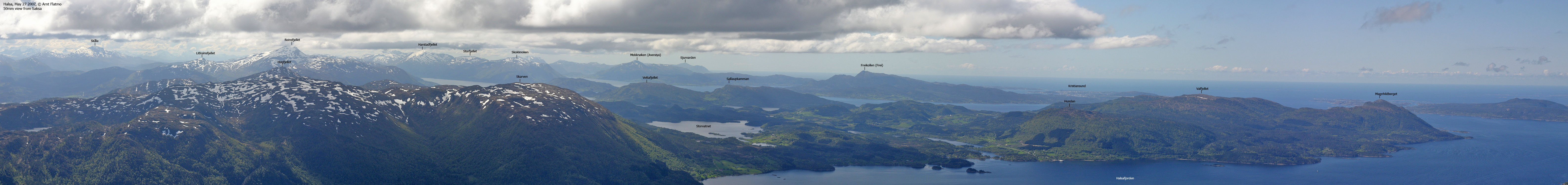
So, now I was on the beaten path and on my way to Saksa. After a tiresome walk (still carrying Troll) up the steep ridge, I reached the summit 15:15PM. A couple was lingering a few yards away, and we chatted for a while. Troll tried to frisk them for goodies, but came up short and went to sleep. A few clouds ruined the perfect panorama towards Trollheimen, Sunndalsfjella and Romsdalsfjellet, but I was still fairly happy about the outcome. I had never seen the Trollheimen and Sunndalsfjella mountains before. I looked forwards to get back home and figure out what I had been looking at.
We took the same route down, and Troll - the downhill dog - was now walking. The following day was a public holiday, and my original plan had been to camp out and visit Hjelmen the next day. But I .. we .. were sort of content and wanted to get back home. I had walked (and almost carried the dog) 3100 vertical meters in little over 24 hours, and I didn't feel the URGE to continue the tour. We reached the trailhead 17:00PM. I pulled down the roof and had a NICE drive back to Ålesund, a couple of beers for myself in the evening, and some goodies for Troll.
(Help text (ALT) is available when your cursor is above the thumbnails. Make sure you've got the ALT switch turned on in your browser)
To Saksa


Wide-angle view from Saksa

50mm views from Saksa, 3 parts


205mm (328mm) zoom views from Saksa, 3 parts


300mm (480mm) zoom views from Saksa. Not consecutive. Only "upside" in addition to the zoom level, is that Store Trolla and Ryssdalsnebba are visible.


Other pics from Saksa + descent


No Javascript:
0 1 2 3 4 5 6 7 8 9 10 11 12 13 14 15 16 17 18 19 20 21 22 23 24 25
 westcoastpeaks.com
Other Møre & Romsdal mountains
Other Norwegian mountains
westcoastpeaks.com
Other Møre & Romsdal mountains
Other Norwegian mountains