
Norwegian Mountains, Hordaland
Stavsnuten, 1661m
| County/Municipality : | Hordaland/Odda | ||||||||
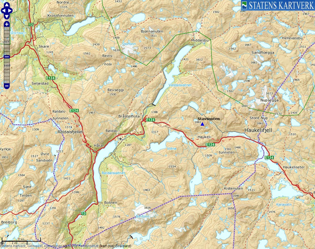
| Maps : | 1414-IV Haukeliseter (Statens Kartverk, Norge 1:50 000) | ||||||||
| Primary factor : | 411m | ||||||||
| Hiked : | July 2010 | ||||||||
| See also : |
| ||||||||
| See also : | Other Hordaland mountains |

Stavsnuten
(Click for larger image)
Introduction
Stavsnuten is one of the impressive mountains that rise steeply above highway E134 across Haukelifjell, and is also one of the highest mountains on the Hardangervidda plateau. The normal route runs up Middyrdalen and unless you have a bike, you're looking at a 5,5-6km walk to the summit. 3,3km of these runs along the road to Middyrvatnet. There is no path up the mountain (the terrain is rocky), but you can see cairns here and there. There are no difficult sections on the easiest route, but still this is not typically a beginner's mountain.
Also consider visiting point 1587m northwest of Stavsnuten. This is a fairly easy "bonus" top. The road into Middyrdalen is (per July 2010) sadly closed by a gate. Consider bringing a bike if you can...

Into Middyrdalen
(Click for larger image)
Primary factor:
Stavsnuten (Norge 1:50,000: 1661m, Økonomisk Kartverk: -, UTM 32 V 388551 6637452) has a primary factor of 411m towards the higher parent Nupsfonn (1690m). The defining saddle (approx. UTM 32 V 388657 6638483) is found in Middyrdalen. Ref. Norge 1:50,000 (20m contours), the saddle is within the range 1240-1260m, interpolated to 1250m.

Stavsnuten terrain and lake 1468m
(Click for larger image)
Google map
Google's interactive map. You can zoom, pan and click on the markers.
|
|
|

Trail descriptions
| This disclaimer is regarding all of the literature and instructional guides posted on the westcoastpeaks.com website. These instructions are guidelines only, and should not be used in lieu of common sense or judgement when attempting any of the actions involved or instructed. Westcoastpeaks nor myself will not be liable nor will it indemnify any form of compensation to anyone who has injured, harmed or even killed themselves or others while following any of the instructions written within the website. It should be noted by any persons willing to undertake any of the instructions provided that mountains offer varying levels of risk, regardless of size or incline. Risks to be considered are as follows but not limited to: wild animals, weather, the terrain, bad judgement, inappropriate or insufficient equipment, improper training or experience and of course, bad luck... |
The route description is valid per July
2010.
|
Route 1: Ulevåbotnen - Stavsnuten (summer/autumn)
|
|


Access
(all distances are approx. distances)
The starting point for this route description is the Haukelifjell. Locate the Haukeliseter tunnel by Ulevåvatnet. At the eastern tunnel entrance, follow the old road (N59.84953 E7.08656) to the west for 1,7km. Turn right onto the road into Ulevåbotnen (N59.84575 E7.05820). After 0,8km you reach the road into Middyrdalen (N59.85301 E7.05728). It is most likely closed by a gate. Find parking nearby.
The route

The route, as seen in Google Earth
(Click for larger image)
Follow the Middyrdalen road for 3km (N59.86822 E7.01529), then decide on a good route up to the pass between Stavsnuten and point 1587m. There are cairns that will help you get going in the right direction, but you may have to find a route around steep fields of snow.
Once you're on Stavsnuten's west ridge, follow it to the top. The terrain is slightly rugged here and there, but if you take the time to look for the easiest route, there are no difficult sections. The summit (N59.85962 E7.01013) is marked by a pile of rocks.
Pictures and Trip reports:
- Stavsnuten, July 24 2010
- Stavsnuten seen from other mountains
 westcoastpeaks.com
Other Hordaland mountains
Other Norwegian mountains
westcoastpeaks.com
Other Hordaland mountains
Other Norwegian mountains