
Norwegian Mountains, Sogn og FjordaneStedjeåsen, 624m (Stedjåsen)
|
| Fylke/Kommune : | Sogn og Fjordane/Sogndal | ||||||||||||||||||||||
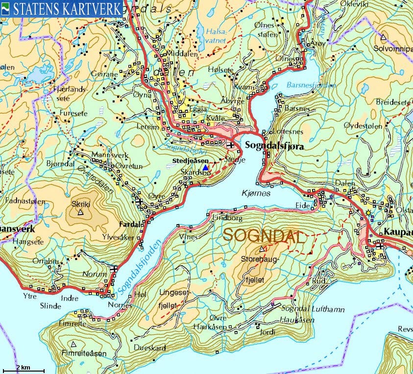
| Maps : | 1417-III Sogndal (Statens Kartverk, Norge 1:50 000) | ||||||||||||||||||||||
| Primary factor : | 121m | ||||||||||||||||||||||
| Hiked : | Dec 2009 | ||||||||||||||||||||||
| See also : |
| ||||||||||||||||||||||
| See also : | Other Sogn og Fjordane mountains on westcoastpeaks.com |

Stedjeåsen
(Click for larger image)
Stedjeåsen rises out of the town Sogndal by Sognefjorden. The normal starting point is the Stedje church, and you'll reach the top within 1,5 hour, on a well-worn path. You'll cross through both spruce and birch forests and pass a couple of old farm buildings in the forest.
The "official" Stedjeåsen point is a tree signposted "Stedjeåsen". The high point is found 240m to the southwest, but because of the boggy meadow in-between, few find it interesting to visit this unmarked point. If you continue along the path to the south (a loop in the upper forest), you will pass a viewpoint where you'll get a clear view of Norafjorden (a part of Sognefjorden)
")
Norafjorden (part of Sognefjorden)
(Click for larger image)
Stedjeåsen (Norge 1:50,000: 625m, Økonomisk Kartverk: 624m, UTM 32 V 396354 6788239) has a primary factor of 121m towards the higher parent Slakkafjellet (855m). The defining saddle (approx. UTM 32 V 395934 6788814) is found at Skardet - the pass between these two tops. Ref. Økonomisk Kartverk (5m contours), the saddle is within the range 500-505m, interpolated to 503m.
GPS measurement read 624m (on the ground), averaged over a 5-minute period (error margin +/- 5,2m).

On Stedjeåsen high point
(Click for larger image)
Google's interactive map. You can zoom, pan and click on the markers.
|
|
|
|
Route 1: Sogndal - Stedjeåsen (summer/autumn)
|
|
This route description is valid per Dec 2009
Access
(all distances are approx. distances)
The starting point is Sogndal (has an airport). From the RV5/RV55 junction south of Sogndalselvi river, drive south 500m on Stedjevegen (RV55). Turn right onto Kyrkjevegen. Drive 350m up the road and turn right again and find parking by the Stedje church.

Stedjeåsen trailhead
(Click for larger image)
The route
From the church, head south up the Rødstokken road and continue on a path that passes the uppermost road at Stedjeåsen. Head up a grassy hillside and follow the path into the forest. The path runs in the east direction (300m) before it climbs Stedjeåsen's northeast ridge.
At approx. 550m, the path forks. This is a loop. Stay right and continue up to the meadow and the official Stedjeåsen point (see picture below, UTM 32 V 396528 6788403). If you want to visit the (unmarked) high point (UTM 32 V 396354 6788239), cross the boggy meadow and find the high point 240m to the southwest.
Upon descent (from the official point), follow the loop to the south and locate the Sognefjorden viewpoint (UTM 32 V 396643 6788203). Then follow the path in the northeast direction until you join your ascent route.

Stedjeåsen official point
(Click for larger image)
 westcoastpeaks.com
Other
Sogn og Fjordane mountains
Other Norwegian mountains
westcoastpeaks.com
Other
Sogn og Fjordane mountains
Other Norwegian mountains


