
|


Storheimshornet is an accessible mountain both on foot and on skis. The mountain is located above the place Stordal by Storfjorden. Storheimshornet connects to the Sandfjellet - Storbotnshornet massif through the Rikjendskaret pass, and it is a fine viewpoint towards these higher mountains. From the trailhead, you can get to the Botnastølen cabins on path. From here on, just follow the gentle slopes towards the top. It is also an option to include Benkene (1185m) on this trip.
The name comes from the place Storheim, south of the mountain. The Storheim locals have additional routes to the top. One example is a traverse via Midtbustsætra and Turrnusa. It is also possible to follow a path up to Mosætra and continue off-trail up Storheimshornet's southeast ridge. This path is likely to be overgrown by bush, and the terrain is rocky.
Although higher mountains all around block for the longer views, Storheimshornet is a good viewpoint if you want to get an overview of the local region. Some "distant" mountains, such as Fedalsnibba can clearly be seen 46Km to the south.
Storheimshornet (M711: 1048m, Ø.K.: -, UTM 32 V 400825 6919593) has a primary factor of 175m towards the higher parent mountain Benkene (1185m). The defining saddle (approx. 32 V 401282 6920146) is found in Rikjendskaret between the two tops. Ref. the M711 map (20m contours), the saddle is defined as a fixed point - 873m. There are no humps and bumps in this saddle, so it is reasonable to assume that 873m is the actual saddle height.
Notes: Class ratings are in reference to YDS. Click here for more information.
The trails described below are not necessarily the *easiest* trails to this mountain.
|
Jasvoll - Storheimshornet (summer/autumn)
|
|
Access
From Ålesund, follow highway E136->E39 towards Åndalsnes. From the E136/E39/Olsvika roundabout near Breivka, follow E39 28Km to the RV650 junction just after Sjøholt. Turn right onto RV650 (Geiranger/Stordal) and continue approx. 23,4Km on this road. Turn left towards "Overøye" and drive 1,7Km up to a turn-out just before a bridge. You will see the "snuplass" sign. Park here.
The route
Follow the gravel road (closed by a gate) 100m upwards. Then turn right onto a smaller road. This road ends after 100m and the forest path to Jasvollsætra begins. You cross a bridge and follow a visible path all the way to Jasvollsætra.
Continue past the uppermost building where you get onto a short "boulevard" before the path towards Botnastølen begins. At Botnastølen, turn westbound and pick a route towards Storheimshornet. You can stop via Mohornet (883m) for additional valley views that you won't get on Storheimshornet.
The high point is located 116m NW of the viewpoint cairn. I built a small marker on the high point. Return your ascent route.
With highly unclear weather ahead, I drove from Ålesund with "no particular place to go". I watched the seafog crawl across the Haram mountains and decided to go further into the country. I chose Storheimshornet as the goal. If I was heading into rain, then the hike wouldn't take too long. I hoped to get some views. On a trip to Jolgrøhornet in the beginning of the year, we didn't see much.
The dog and I left the trailhead 13:00PM and fairly soon, I had to carry the dog up the forest. Seldom have I seen him less inspired. The forest path was nice to follow, and we passed Jasvollsætra 20 minutes later. Botnastølen was reached 13:45PM. To be accurate, I left the trail 200m before the first cabin and headed upwards in the direction of Mohornet. I ran into SOFT snow at 550m elevation and had to put on the snowshoes.
This trip could have justifed bringing skis, but it is very inconvenient to mount the skis on the backpack while carrying the dog. There isn't enough room for him when the skis have been tightened to the backpack, so on a hike like this, snowshoes are more practical. I was fortunate and had sunshine while the fog was hitting on Medhornet, on the other side of the valley. The light was intense, and my eyes were hurting everytime I took the sunglasses off. It was a hot day and no wind. Even with a soaking wet woollen sweater, there was never any reason to consider the wind-jacket.
I reached the top 14:50PM and had carried the dog all the way. I suddenly got hungry and realised that I had forgotten about breakfast. While Troll was having his lunch, I ate the remaining nuts from the Ytstetinden hike 3 days earlier. The high point had no marker, and I built a small one before leaving the top 15:15PM.
I had plans to descend directly from Mohornet to Jasvollsætra, but now that the dog hadn't walked at all, he was going to get excercise. Even with my two-way snowshoe tracks, he struggled hard in the wet snow. But he made it down to Botnastølen and kept a good pace down the forest path. We were back at the car 16:25PM.
I drove down towards Stordal and took a picture of the mountain. I shopped for groceries at Stordal and when I left, fog swept across the summit. 2 minutes later, it began to rain. Good timing.
Note: Apologies for the poor picture quality. My camera was at the repair shop, and I had to bring along the 4-year old Nikon Coolpix 4500.
To Storheimshornet


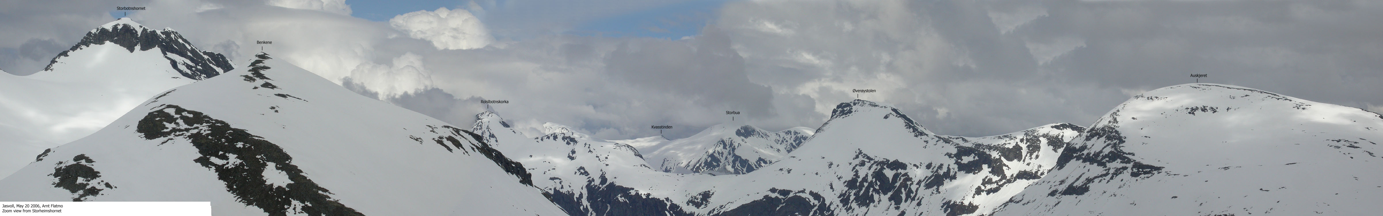
Wide-angle panorama from Storheimshornet

Misc. views from Storheimshornet


Descent


No Javascript:
1 2 3 4 5 6 7 8 9 10 11 12 13 14 15 16 17 18 19 20
 westcoastpeaks.com
Other Møre & Romsdal mountains
Other Norwegian mountains
westcoastpeaks.com
Other Møre & Romsdal mountains
Other Norwegian mountains

