
|

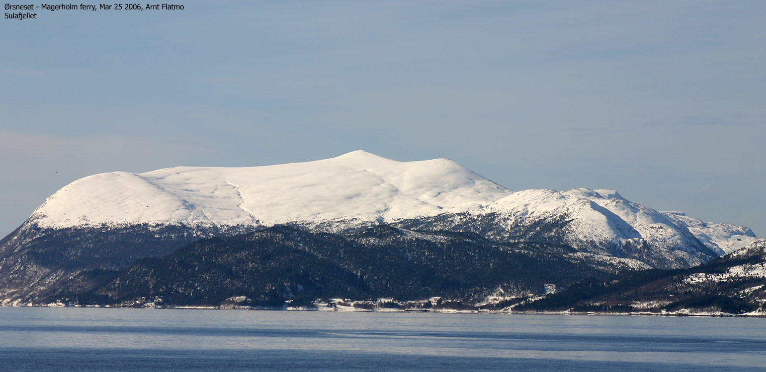
Sulafjellet is a common name for the mountain massif that dominates Sula island. It is located outside Ålesund along the Sunnmøre coastline. Sula on Sunnmøre should not be confused with Sula island in Sogn og Fjordane county. The high point is known as "Vardane" ("the cairns") on maps, and the summit serves this name well. The name "Tverrfjellet" is also found near the high point, and it is likely that this is the map name for the entire Sulafjellet massif.
Sulafjellet falls steep down to the sea on most sides, and there are several named viewpoints, such as Sulabakkhornet, Flesjehornet, Kjellingsethornet, Grøthornet, Rundehornet, Svanshornet, etc. There are also "numerous" trails that lead up the mountain. This web page will (over time) describe all of the MAIN routes to the top.
The views are phenomenal. To the north and the west, you have the coastal mountains, and to the east and the south you will see an "endless" row of wild mountains, mostly refered to as "Sunnmørealpene" - the Sunnmøre alps. Sunnmøre is the southernmost region in Møre og Romsdal county.
The summit has several cairns, and the main cairn is *huge*. This cairn was destroyed by lightning January 14 1989 and rebuilt July 2 the same year. This, and more can be read (in Norwegian) on the rotating plate that identifies the prominent peaks you see in the horizon.
It takes half an hour (or less) from Ålesund to the nearest trailhead (Mauseid). Along the way, you pass Blindheimsfjellet - the west side of Uksenøya peninsula. Both Sulafjellet and Uksenøya offer excellent terrain for skiing and hiking, but it is harder to plan roundtrips if you need to get back to the starting point. In this contect, Sulafjellet is perhaps a better choice, and the views are even better (wider).
Sulafjellet (M711: 776m, Ø.K.: 776,34m) has a primary factor of 776m being the Sula island high point.
Of all the other minor tops on Sulafjellet, Svanshornet (552m) is the most prominent, with more than 50m drop towards the high point.
Notes: Class ratings are in reference to YDS. Click here for more information.
The trails described below are not necessarily the *easiest* trails to this mountain.
|
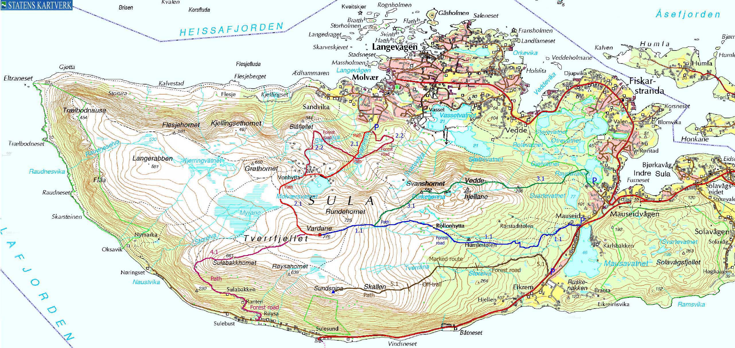
Route 1.1: Mauseid - Vardane (all seasons)
|
|
Access
From Ålesund, follow highway E39 towards Bergen. From Solavågseidet, follow highway RV61 towards Hareid. Approx 3Km after the E39/RV61 junction, turn right towards "Eikrem" and you will immediately see a large parking area. Park and study the trailmap that is posted here.
The route
Head up the nearest road, passing houses. Take the first forest road that forks left from the road you are on. Along the way, you will run into several forest road junctions. Follow signs towards "Rollonhytta". Rollonhytta is a cabin located at approx. 390m elevation and may be open for warm drinks and snacks. I will add more information about this cabin later on.
The forest road ends here by this cabin, but a path continues towards Vardane. In winter, you may choose where you want to ascend the upper mountain.
Descend your ascent route, or visit Svanshornet on your way down.
Click here for pictures from this route.


|
Route 2.1: Langevågen - Vardane (all seasons)
|
|
Access
From Ålesund, follow highway E39 towards Bergen and subsequently RV61 towards Hareid. 5,4Km after you pass the "Stranda" exit on your way from Ålesund, leave RV61 and turn right towards "Langevågen". Pass Mauseidvåg and Fiskarstrand before you get to Langevågen. 8,6Km after you left RV61, turn left onto the "Molværsbrautet" road, just after a SPAR grocery store (per May 2006) and follow this 800m upwards. You arrive a large parking area. Park here.
The route
Locate the bridge that takes you across Molvægrselva river. Continue upwards on a wide path. At 250m elevation, you cross a forest road that runs from Vonhytta to the trailhead you left. Only the western side has been outlined on the map above (route 2.2).
Cross this road and continue up the path that runs on top of the pipeline from Molværsvatnet. Once at the lake, follow the dam in the direction of the cabin village. Head up the highest cabin - Vonhytta - and proceed on path up to the summit plateau. You arrive this plateau by a large cairn, and approach the main summit from the west.
Descend your ascent route, or take the road (route 2.2) from Vonhytta. Alternatively, follow route 1.1 down to the Svanshornet - Vardane saddle and locate a path that runs down to the Langevågen trailhead. I have not yet followed this trail, but it will be documented soon.
Click here and here for pictures from this route.


|
Route 3.1: Ingeskogen - Vardane via Svanshornet (summer/autumn)
|
|
Access
From Ålesund, follow highway E39 towards Bergen and subsequently RV61 towards Hareid. 5,4Km after you pass the "Stranda" exit on your way from Ålesund, leave RV61 and turn right towards "Langevågen". At the next two junctions, do not turn right towards Langevåg or left towards Hareid. If you just drive "straight ahead", you will reach Ingeskogen (street sign) 1,2Km after you left RV61. Park next to a rack of mailboxes.
The route
Head across a short grassy field (northwest), cross a creek and a meadow via rocks that have been put in place there. The path turns right (northeast) and leads to Lake Råudåvatnet. The path continues along the lake's west shore for 100 meters before it turns sharp left (southwest) in a junction. The junction is marked "Fiskarstrandhyttane". Follow this path. Stick to this path all the way to Svanshornet (ignore path towards "Gjølevatnet) in a junction shortly after the "Fiskarstrandhyttane" junction.
On the way to Svanshornet, you pass a couple of cabins at approx. 290m elevation. Pass these cabins to the left, cross a meadow leading up to Veddehjellane, pass Lake Purkjetjønna on the north side (and a handfull of small cabins next to the lake) before you reach the top of Svanshornet.
I have not hiked from Svanshornet to Vardane, but according to the map, there is a path. Descend from Svanshornet to approx. 490m elevation before you join a path from Rollonhytta, which leads directly up to the summit. Descend your ascent route, or follow route 1.1 to Eikrem. At Eikrem, you're only 1Km (along the road) away from the Ingeskogen trailhead.
Click here for pictures from this route.


|
Route 4.1: Sulesund - Vardane via Sulabakkhornet (summer/autumn)
|
|
Access
From Ålesund, follow highway E39 towards Bergen and subsequently RV61 towards Hareid. Drive all the way to Sulesund, but turn right onto Nøringsetvegen (signed) just before the ferry (to Hareid). Follow this road 1,7Km and you will see a gravel on your right-hand side and a turn-out for 3-4 cars a few meters ahead (on the other side of the stream). Park there.
The route
Follow the gravel road, which turns into a forest road after 50m. Pass the farms Ranten and Sulabakken before you enter the forest path. At 260m elevation, make sure you turn right in a (vague) path junction. The path climbs steep northbound from here, onto a plateau higher up. The path then continues northwest and passes a cabin at 450m. The path on the map continues into the valley ahead of you, but I suggest you head up to the cabin and follow a path directly up to Sulabakkhornet, which is more a viewpoint than a top. Proceed northeast across the plateau towards Vardane on a vague path, although you don't need paths on this elevation.
Click here for pictures from this route.


|
Route 5.1: Eikrem - Sundsnipa (summer/autumn)
|
|
Access
From Ålesund, follow highway E39 towards Bergen. From Solavågseidet, follow highway RV61 towards Hareid. Approx 4,1Km after the E39/RV61 junction, locate the Eikrem trailhead on the right-hand side of the road. You will see a bus stop on either side of the road. Find parking on the right-hand side of the road.
The route
A forest road begins by the main road (lots of trailsigns here). Follow this road 450m and turn left in the upcoming junction (the road to the right runs to Mauseid). Continue on forest road until you cross Storelva river on a bridge. 120m after you've crossed the river, the forest road has ended and you have reached yet another trail junction. Ignore the route marked with sticks. Instead, follow a route marked by yellow "T's" eastbound through the forest. The path is VERY vague, but it is easy to follow the "T's".
Approx. 880m west of Storelva, you may lose sight of the "T's". See if you can spot a trailsign and a bridge 200m further right. After you've crossed the creek, you run into a route marked with sticks. I think this route is "Skalleruta", but I never figured out where it went. Ignore this marked route and head off-trail 700m in the southwest direction, and you should be able to see a vague path that runs up Skallen's east ridge.
From Skallen, continue 700m westbound on the plateau, and descend directly towards Sundsnipa. The top of Sundsnipa is marked by an amazing rock. You get "extra bonus" for visiting a very cool viewpoint southwest of Sundsnipa. You need to scramble onto this airy ridge that drops steep towards Sulesund.
The top of Sulafjellet - Vardane - is located 1,2Km north/northwest of Sundsnipa. The terrain is easy to follow. Consider descending route 1.1 (via Rollonhytta) down to Mauseid, and follow the forest road that runs between Mauseid and Eikrem.
Click here for pictures from this route.


 westcoastpeaks.com
Other Møre & Romsdal mountains
Other Norwegian mountains
westcoastpeaks.com
Other Møre & Romsdal mountains
Other Norwegian mountains

