
Norwegian Mountains, Sogn og FjordaneSynnevaskjer, 1543m
|
| Fylke/Kommune : | Sogn og Fjordane/Sogndal & Leikanger municipalities | ||||||||||||||||||||||
| Maps : |
1417-IV Solvorn (Statens Kartverk, Norge 1:50 000)
1317-I Fjærland (Statens Kartverk, Norge 1:50 000) |
||||||||||||||||||||||
| Primary factor : | 133m | ||||||||||||||||||||||
| Hiked : | Mar 2011 | ||||||||||||||||||||||
| See also : |
| ||||||||||||||||||||||
| See also : | Other Sogn og Fjordane mountains on westcoastpeaks.com |

Synnevaskjer seen from Torstadnakken
(Click for larger image)
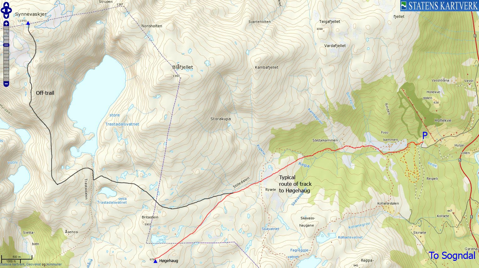
Synnevaskjer is a mountain top that is mostly visited by skiers, and normally from the Hodlekve ski-centre in Sogndalsdalen. You can either ski via Høgehaug or via Blåfjellet. There is a good chance that you can follow prepared tracks to Høgehaug and Vardafjellet, making part of the (fairly long) trip a bit easier. This page will describe a route that passes close to Høgehaug. See this page for a route description to Blåfjellet.
There are no difficult or very steep sections on the Hodlekve - Høgehaug - Trastadalen - Synnevaskjer route, but the route is long (10,5km) and the vertical gain is close to 1100 meters. A section between the 1260 and 1320m contours on Synnevaskjer's south ridge can be tricky if the snow is hard. The Sogndal/Leikanger municipality border runs across the summit.

Synnevaskjer seen from Storehaugfjellet
(Click for larger image)
Once on Synnevaskjer, you can continue west to point 1570m on Myrdalsbreen/Voggebreen. You can also keep heading north (from point 1570m) across Ryssebotnrana, Skjerdingane and Frudalshesten and return to Sogndalsdalen near Frudalstunnelen - an advanced skiing route!

Synnevaskjerseen from Kjeringi
(Click for larger image)
Synnevaskjer (Norge 1:50,000: 1543m, Økonomisk Kartverk: -, UTM 32 V 385149 6798174) has a primary factor of 133m towards the higher parent point 1570m. The defining saddle (approx. 32 V 384238 6797791) is found between Synnevaskjer and Myrdalsbreen. The exact location is either east or west of point 1482m. Which side has the lower pass is uncertain. Ref. Norge 1:50,000 (20m contours), the saddle is within the range 1400-1420m, interpolated to 1410m.

Synnevaskjer seen from Blåfjellet
(Click for larger image)
Google's interactive map. You can zoom, pan and click on the markers.
|
|
|
|
Route 1: Hodlekve - Synnevaskjer (winter)
|
|
This route description is valid per Mar 2011
Access
(all distances are approx. distances)
The nearest bigger town is Sogndal (has an airport). From the highway RV5/55 junction in Sogndal (roundabout), follow RV5 11km up Sogndalsdalen. Turn left when you seen the Hodlekve (Hollekve) signpost. Drive up to the ski-centre parking. There may be a parking fee - NOK 30,- per Mar 2011.
The route
Follow the (hopefully) prepared track in the direction of Høgehaug. The route passes the Stedjekammen cabins, continues across a meadow before it ascends up Stilledalen valley. The actual route will vary from season to season, but will most likely run all the way to Høgehaug (978m - N61.26723 E6.90540).
From Høgehaug, you can proceed north/northwest across Britastein and aim for the drain from Stora Trastadalsvatnet, but it would be better to leave the track early in Stilledalen (as shown on the map above) and have a more direct approach towards the drain.
Descend into Trastadalen and rise out of it as soon as you can. Continue southeast up a ridge until you meet Synnevaskjer's south ridge. Follow this ridge to the summit (N61.30077 E6.85593), marked by a medium-sized cairn.

The ridge route to Synnevaskjer
(Click for larger image)
|
|


