
|

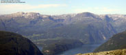
Reinskardnuten and Vassfjora seen near Jonstøl |
Vassfjøra, or Vassfjøro as many people say, is the 25th highest mountain in Hordaland Fylke and ranks modestly as number 78 based on the primary factor. This is however of academical interest, as you will never forget this mountain after admiring its magnificient south face. There are many steep and grand mountain sides in Hordaland, but few mountains express character like Vassfjøra. Hårteigen is another mountain in this category. I find these mountains majestic, and they make me feel small and humble.
In terms of mountains, Vassfjøra is the pride and joy of Ulvik. It is the highest mountain in proximity to the Ulvik community centre, but is far from the highest point in Ulvik Kommune as the Hardangerjøkulen glacier summit point (1863m) belongs to Ulvik and Eidfjord.
The hikes to Vassfjøra are classic, but demanding. The routes are long and strenuous. Although the common routes are non-technical (US class 2), the routes still require fit and strong hikers. If clouds and ugly weather hits the mountain, then navigation and routefinding is essential. The routes only go where the mountain permits. The normal routes (one on the east side, and one on the west side of the mountain) run from the Ulvik region. The mountain is easier reached from the north, but this assumes you already are traveling in the large mountain region north of the mountain. Bergen Turlag arranges hikes to this mountain if you prefer to hike this mountain with company.
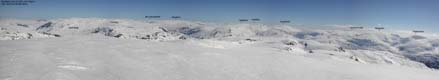
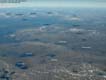
The viewsched is enormous, due to Vassfjøra's height. In the north-east /east you see Hemsedal mountains, Hallingskarvet and Hardangerjøkulen. In the south you see far onto the Hardangervidda plateau. In the west you have the Raundalsegga ridge and numerous mountains in the north, with Fresvikbreen as a landmark. You can also see Gaustatoppen from Vassfjøra on a clear day.
Reinskardnuten is a hump located north of Vassfjøra, above Miningane. The drop to the Vassfjøra saddle is high enough (106m) to qualify this top as a standalone mountain. If your route is up and down the east side, then this mountain is off your track. But if you come up via Miningane on the west side, then it doesn't take you long to collect a bonus summit.
Primary Factor
Vassfjøra has a primary factor of 363m towards the higher Baksafjellet. The saddle is found south of Skipanuten, and the last adjacent 20m contours are 1280m. The saddle height has been interpolated to 1270m.
Reinskardnuten has a primary factor of 106m towards the higher Vassfjøra. The saddle is found south of Reinskardnuten, and the last adjacent 20m contours are 1320m. The saddle height has been interpolated to 1310m.
Note: Class ratings are in reference to YDS (Yosemite Decimal System).
Note: The trail described below is not necessarily the easiest trail to this mountain.
|
Ljono - Miningane - Vassfjøra - Jonstøl - Ljono round-trip (summer/autumn)
|
|
Access
From Bergen, follow highway E16 towards Oslo. From the central traffic light in Voss, drive straight ahead (do not exit left towards E16) and join highway 13 further ahead. Go right on highway 13 and after 22Km from the Voss traffic light, exit left onto highway 572 by lake Granvinsvatnet. Follow this road for approx. 18,8Km and go left towards Ljono 200m before the main junction in Ulvik.
Alternatively, follow E16 from Bergen towards Oslo and turn right in the Trengereid roundabout. Follow highway 7 towards Norheimsund and Hardangerfjorden. Follow highway 7 northbound until you join highway 13 near the Vallavik tunnel. Drive through the tunnel and all the way to Ulvik. At the central junction in Ulvik, turn left and exit towards Ljono after 200 meters.
Follow the road towards Ljono for approx. 3,2Km. Turn right onto a gravel road and follow it for 200m. Find parking (1 car) by the trailhead gate or locate parking elsewhere. Do not block for other traffic.

The route
To Vassfjøra
Go through the first gate (several gates follow. Make sure you close them all) and follow the forest road for approx. 700m. Shortly after the forest road makes a sharp left turn, locate a yellow ribbon on a tree on the right hand side. It is hard to spot, but a vague trail will provide a shortcut towards lake Solsævatnet. Alternatively, follow the gravel road all the way to the lake and connect to the forest road on the east side of the lake.
The path runs across Gårdhovden and grows gradually more visible. This terrain can be wet and muddy. At the south-east end of lake Solsævatnet you pass a trail junction (you see the Ulvik/Solsæ sign nearby). You will be coming down on the trail to your right. Follow the trail until it joins the gravel road near the south-east end od the lake, and turn north along the gravel road. At Solsæ, you will cross the bridge over the river Eitro, just before the cabins. A little further along, the road becomes a forest road and crosses the bridge over river Øyarstølselvi, near the north-east end of the lake. Shortly after crossing this bridge, turn north-east onto the trail that will take you up the mountain. After crossing the river Sveigselvi, inside the spruce forest, the trail climbs gently and gradually up to nedre Sveig. You will be passing an old ruin of a cabin at nedre Sveig. Make sure you locate the trail to lake Ljoneskrulen at the far end of the meadow at nedre Sveig. Then follow this trail in a north-east direction yntil you reach lake Ljoneskrulen.
At lake Ljoneskrulen, stay on the lake's lefthand (west) side. When you reach the boulder section, seek high in the basin. Some sort of trail runs through the boulder, and makes hiking all the more easier. The trail stays high and runs just below the steep cliffs as you approach the inner basin. When you reach the stream from the mountain, stay on the left hand side and follow a grassy pitch steep upwards. You have an open valley in front of you, but although this may be a good route upwards, do not go into the valley. Follow the grass as it curves left and hits a cliffband of flat rock (Miningane). In the middle of this cliff, locate manmade steps which offers a smooth ascent of this cliff. Above the flat rock, follow an obvious corridor north-west towards lake Kvannjolvatnet. This corridor is narrow and close to the edge, but you have all the protection you need in the terrain.
Once you have lake Kvannjolvatnet in view, you have a distinct ridge up to your right. Either follow the ridge upwards (you may run into class 2+ terrain here), or hike up between the ridge and the steep cliffs below Reinskardnuten. When you reach the upper plateau with a view up towards Vassfjøra then consider if you want to collect Reinskardnuten as an extra bonus. If so, then follow the steep cliffs until you find a route up that you are comfortable with. You will find a class 2 route on the north-east side of the mountain, while there are several class 3 routes along the mountain. There is also an obvious grassy pitch upwards just before you reach the plateau. It looks safe from below, and deserves investigation.
Go around Svana on the south-west side. You have two options:
a) Pass point 1294m on the east side, cross the stream from the nearby pond,
continue south-east until you arrive cliffs with a large snowfield below.
Turn left (east) and follow the ridge to the top and then cross over to the
summit plateau.
b) Before arriving 1294m, turn east, pass the lake east of Svana and
climb onto the ridge that runs via point 1546m. This detour is approx. 1Km longer
than the alternative a).
Once on the main summit ridge, pass point 1621m, descend slightly and continue up to the 1633m summit.
From Vassfjøra
Halfway between point 1621m and the summit, on the plateau's east side, head down in the north-east direction. You should be able to see small cairns that will guide you down to the pond 400m below.
At the pond, set a southbound direction and leave the basin through a gorge where the pond drains down to the valley. The cairn trail begins just as the route starts descending. The terrain is slightly cumbersome, but the cairns will guide you safely down. At the very beginning of the trail, you will follow a short ledge which I imagine can be exposed when hard snow has built up on the ledge.
In front of you, towards the right, you have large green hillsides. Set a south-west course and hike down to lake Svartavatnet (2,5Km hike). The Herbergsryggen ridge is up to your right, and further above you have the grand east face of Vassfjøra. From lake Svartvatnet you have a 3Km hike in front of you before you reach the Jonstøl cabins. Before you reach Jonstøl you will pass lake Heimavatnet on the west side.
From Jonstøl, maintain the south-west direction and after 600-700m, notice a trail forking off to the right next to a sign. Follow the trail to the right. The trail is for the most part easy to follow. At one point the trail disappears. Seek into the forest to your right, and you will find the trail again. The trail runs through the forest for a good stretch. Eventually you reach a cabin in the forest. Just continue straight ahead with the cabin on your right hand side and pick up the trail further down. Shortly after, you run into the trail you were on when you hiked upwards. Turn left and follow the same route back to the trailhead.
|
After the Skorafjellet hike 20/7, Torbjørn Frøystein and I agreed that we should try to do a Vassfjøra traverse later in the summer. The opportunity came this week-end, and we agreed that we should meet in Ulvik 08:00AM Sunday morning. As Ulvik is more than 2 hours away from Bergen, one has to get up fairly early in the morning. It had been raining all week, but the forecast for this Sunday was surprisingly good. As I passed Osterøy, the clouds were down to 300-400m. I was a little pessimistic about the cloudbase, but decided I would let the morning sun get a chance to burn for a while. It was six o' clock in the morning. Why not practice patience. I got more optimistic when I saw the cloudbase at 1000m while passing Evanger. At Voss, Lønahorgi (1410m) was cloud-free. Good golly! Perhaps this would turn out to be a gorgeous day after all. As I got closer to Ulvik, Vassfjøra was wrapped in clouds. Besides that, the weather was just great. The hike would surely happen.
The long way to the top I met with Torbjørn in Ulvik and we drove to the Ljono trailhead. We started off on a forest road, passing several gates. Suddenly Torbjørn left the forest road and said we were now on the trail. This happened a bit quick. I noticed a yellow ribbon on a tree, but there was no trailsign. And the trail was at the very, very best - vague. Torbjørn explained that the forest road could be followed, but would be a detour. We crossed the Gårdhovden hill before joining the forest road from Tjørnarhals near lake Solsævatnet. I was confused about the number of forest roads and vague trails, but decided to worry about that later. At the north-east end of lake Solsævatnet we got on to the mountain trail. The trail climbed fairly gentle in the north-east direction until we passed Vetle Vassfjellet (858m) and descended down to lake Ljoneskrulen. On the far side of the lake I saw the valley ended sudden in a near vertical mountain side. Up there were the famous Miningane. Above Miningane was Reinskardnuten, throning mighty in a slightly bent, ugly-looking angle. As if the mountain was warning us to stay away. Under normal circumstances, not knowing the route, I would have felt some adrenalin while trying to figure out how to get up. But since Torbjørn had been researching the area some weeks earlier, I already knew that Miningane was a lot less scary than how it could be perceived from distance. There were people in the cabin on the west side of lake Ljoneskrulen. We chatted some and had a food break further ahead in the boulder area before we continued towards Miningane. A slightly visible path indicated the route upwards, and I found the route to be steep and strenuous, but not exposed. We passed the flat rock cliffs at 10:50AM, 3 hours after leaving the trailhead. Once Miningane was defeated, I concluded that the ascent was quite easy, although the hillside was rather strenuous. In fog and rain, I imagine this mountain side can present itself in a different manner. We climbed directly onto the ridge that took us to the plateau below Reinskardnuten. I had discovered along the way that Reinskardnuten actually was a separate mountain. I smelled a bonus peak. Convincing Torbjørn that getting this summit also was the only sensible thing to do, was easy. He's a peak bagger too, deep down. The mountain had all sorts of interesting routes up the steep cliffs. As we hadn't any time to waste on potential dead ends we decided to walk around the mountain until we found an easy way to the top. We reached the top 11:30AM and had great views from the top. We had our second food stop at the summit. The pace up the mountain had been fast. It was important to compensate with food and water. Once down, we decided to pass Svana on the west side, as we imagined we would lose the vertical gain once we reached the top of Svana. We aimed for a small valley between Svana and Vassfjøra, crossed the stream and headed upwards the mountain. Suddenly we reached some steep cliffs above a glacier-looking snowfield that ran down towards Ljoneskrulen. Instead of climbing down and cross the snowfield, we turned left and scrambled up a long ridge that took us to the top of the snowfield. We then crossed the snowfield's top before moving onto the summit plateau. We reached the Vassfjøra summit 13:20PM. Finally, I was on top of the mountain I had been wanting to hike for so long. It had taken us 5,5 hours to the top (which included Reinskardnuten). We had been hiking very fast, and I made a mental note that this had been an unusual long ascent. And then it was time to enjoy the views. Torbjørn pointed out a dot in the horizon and said this was most likely Gaustatoppen. Hardangerjøkulen and Hallingskarvet with the characteristic Kyrkjdørsnuten dominated the eastern viewsched. Fresvikbreen was easy to identify in the north, but we struggled with the neigbouring peaks west of the glacier. South-east of the glacier was Store Breen and Syrdalsbreen. The southern and western views were quite familiar, covering Hardangervidda, Hardangerfjorden, Voss and Stølsheimen.

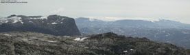
Vassfjøra seen on the way to Osa
Going home Torbjørn signed the summit register. This was his fourth trip to this summit, but the first traverse. After a good meal and a 30 minute break on top, it was time to explore the descent route. We left the summit 13:50PM. I had been worried that fog rising from the valleys would make the routefinding difficult, but it never became a problem. The route down to the pond at 1200m was rather obvious. Once we reached the eastern side of the summit plateau, there was only one route down. And it was cairned, which made descending a bit easier. Torbjørn was amazed over the lack of snow. Only one broken snowfield was clinging on to the mountain. Normally, he says, snow is covering most of this mountain side. The beginning of the route down from the 1200m pond was quite interesting, as the route zig-zaged in rugged terrain next to the stream from the pond. The view down towards Norddalen valley was breathtaking. The hike down towards Jonstøl was rather long, but enjoyable. We had an awesome view towards Austdalen, which is the normal gateway towards Onen. Below Vassfjøra, we passed the remainders of and old cable system from the mountain to Osa. In the old days they transported slate rock down from the mountain, and the effort that has been put into building this cable system must have been substantial. We passed the Jonstøl cabins where people were spending the beautiful afternoon in leisure. I was busy looking for a useful route up to Kristinuten, which I have to come back to do. Shortly after Jønstøl, we got on the trail that would take us back to the original trail, and we returned to the trailhead 16:50PM. The hike had taken 9 hours all together, in what I would call a up-tempo pace. In Ulvik, we enjoyed a very welcome meal at Torbjørn's parents. It had been a long, but rewarding day. And the shower and a bed was only 2,5 hours away.
|
Move cursor to read notes, and click on the images to see full version.
Some of the thumbnails may have been cropped to fit the format.
Pictures are presented in the order they were taken.
Going up


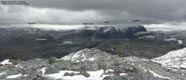
Views from the summit plateau


Going down


 Other hordaland mountains
Other Ulvik K. mountains
westcoastpeaks.com
Other hordaland mountains
Other Ulvik K. mountains
westcoastpeaks.com

