
Norwegian Mountains, Sogn og FjordaneAmlaholten, 508m (Amleholten)
|
| Fylke/Kommune : | Sogn og Fjordane/Sogndal | ||||||||||||||||||||||
| Maps : | 1417-III Sogndal (Statens Kartverk, Norge 1:50 000) | ||||||||||||||||||||||
| Primary factor : | 265m | ||||||||||||||||||||||
| Hiked : | Dec 2009 | ||||||||||||||||||||||
| See also : |
| ||||||||||||||||||||||
| See also : | Other Sogn og Fjordane mountains on westcoastpeaks.com |

Amlaholten
(Click for larger image)
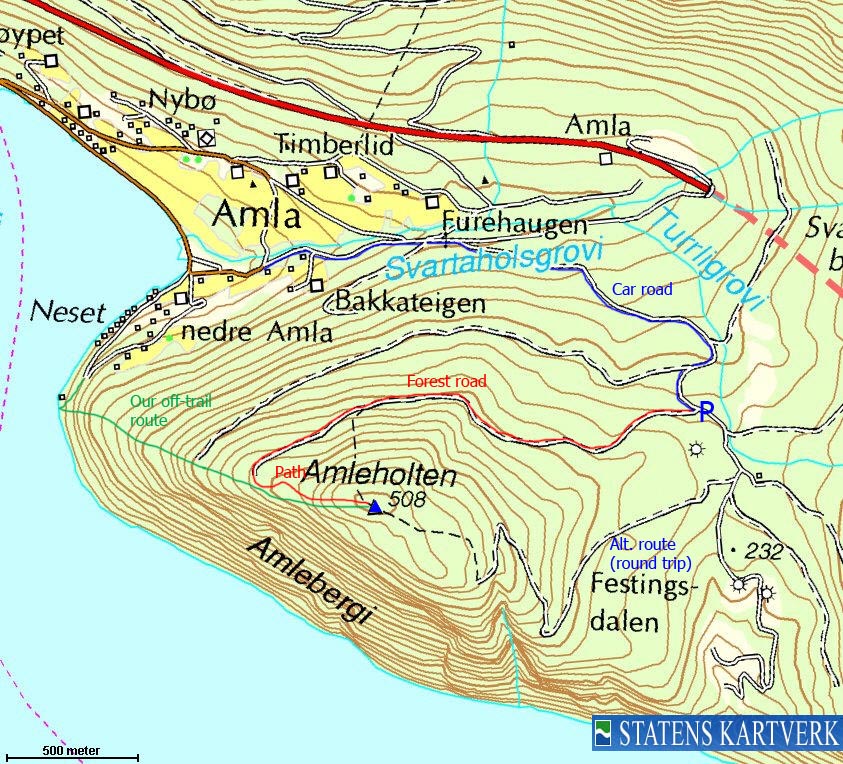
Amlaholten is a forest hill located southwest of Kaupanger, and is a popular hiking top. The normal starting point is from the road to Festingsdalen, from where you can do a round trip hike on forest road and marked forest trails.
Because of trees, the top itself is not the best viewpoint, but if you seek a little to the south, you will find openings and you can enjoy a fine view towards Sognefjorden and the surrounding mountains.
Those who like to step outside the established trails, might enjoy a hike from Neset and up the west ridge. The pine forest is open, and albeit steep, fun as the terrain keeps changing throughout. This route is described in the trip report (see link at the bottom of the page). This page will describe one of the main routes to Amlaholten.

Sognefjorden
(Click for larger image)
Amlaholten (Norge 1:50,000: 508m, Økonomisk Kartverk: 507,88m, UTM 32 V 407400 6782821) has a primary factor of 265m towards the higher parent Søre Gråbrørne (737m). The defining saddle (approx. UTM 32 V 408778 6782966) is found at the top of the Festingsdalen road. Ref. Økonomisk Kartverk (5m contours), the saddle is within the range 245-250m, interpolated to 248m.
GPS measurement read 513m (on the ground), averaged over a 10-minute period (error margin +/- 2,4m).
")
Up the west ridge (off-trail)
(Click for larger image)
Google's interactive map. You can zoom, pan and click on the markers.
|
|
|
|
Route 1: Festingsdalen - Amlaholten (summer/autumn)
|
|
This route description is valid per Dec 2009
Access
(all distances are approx. distances)
The nearest bigger town is Sogndal (has an airport). From the RV5/RV55 junction in Sogndal, follow RV5 in direction of Kaupanger/Fodnes/Lærdal. After 9,3km, turn right towards Sogndal Lufthavn/Kaupanger. Go straight ahead at the 1st roundabout. Drive 2,8km to the Kaupanger ferry harbour and then continue straight ahead (stay right in the 1st fork) and drive 1,1km to a another fork at nedre Amla. Turn left and follow a narrow asphalt road 2,7km upwards. The Amlaholten trailhead is signposted. Find parking a little further up the road.
The route
From the trailhead, follow a forest road 1,9km to the west. Turn east onto a forest path (see picture below) that takes you up to the top. One section is a bit steep, but should be of no concern. The top is marked by a mailbox which may contain a visitor's register.
Descend your ascent route, or follow a path to the west. This path soon turns east and brings you back to the Festingsdalen road, approx. 350m up the road from your trailhead.

On the forest path
(Click for larger image)
 westcoastpeaks.com
Other
Sogn og Fjordane mountains
Other Norwegian mountains
westcoastpeaks.com
Other
Sogn og Fjordane mountains
Other Norwegian mountains


