
Norwegian Mountains,
Sogn og Fjordane
Bjørnanosi, 872m
| County/ Municipality: | Sogn og Fjordane/Luster | ||||||
| Maps: |
1418-III Jostedalen (M711 Norge 1:50 000)
10063 Jostedalsbreen (Norges-serien 1:50 000) | ||||||
| Primary factor: | 79m | ||||||
| Hiked: | June 2013 | ||||||
| See also: |
| ||||||
| See also : | Other Sogn og Fjordane mountains on westcoastpeaks.com |

Grånosi and Bjørnanosi to the right
(Click for larger image)
Introduction
Bjørnanosi is a mountain top close to Vassdalen, high above Jostedalen. The mountain top is not very often visited and is fairly anonymous - compared to the mighty mountains towering high above, reaching twice its height. A good path takes you from Gardshaug to Vassdalsvatnet (736m), and from here you have to go off-trail in order to reach the top. This is the route described on this page.
If you want a really long hike, you can continue across Vassdalsfjellet (1656m) and Breakulen (1678m) and descend via Liadøla and Liastølen.

View from Bjørnanosi
(Click for larger image)
Primary factor:
Bjørnanosi (Norge 1:50,000: -, Økonomisk Kartverk: 872m, UTM 32 V 407783 6825168) has a primary factor of 79m towards the higher parent mountain Vassdalsfjellet (1656m). The defining saddle (approx. UTM 32 V 407582 6825031) is found between these two mountains. Ref. Økonomisk Kartverk (5m contours), the saddle is with the range 790-795m, interpolated to 793m.

Sperlestølen
(Click for larger image)
Google map
Google's interactive map. You can zoom, pan and click on the markers.
|
|
Route descriptions
| This disclaimer is regarding all of the literature and instructional guides posted on the westcoastpeaks.com website. These instructions are guidelines only, and should not be used in lieu of common sense or judgment when attempting any of the actions involved or instructed. Westcoastpeaks nor myself will not be liable nor will it indemnify any form of compensation to anyone who has injured, harmed or even killed themselves or others while following any of the instructions written within the website. It should be noted by any persons willing to undertake any of the instructions provided that mountains offer varying levels of risk, regardless of size or incline. Risks to be considered are as follows but not limited to: wild animals, weather, the terrain, bad judgment, inappropriate or insufficient equipment, improper training or experience and of course, bad luck... |
|
Route 1: Gardshaug - Bjørnanosi
|
|


This route description is valid per June 2013
Access
(all distances are approx. distances)
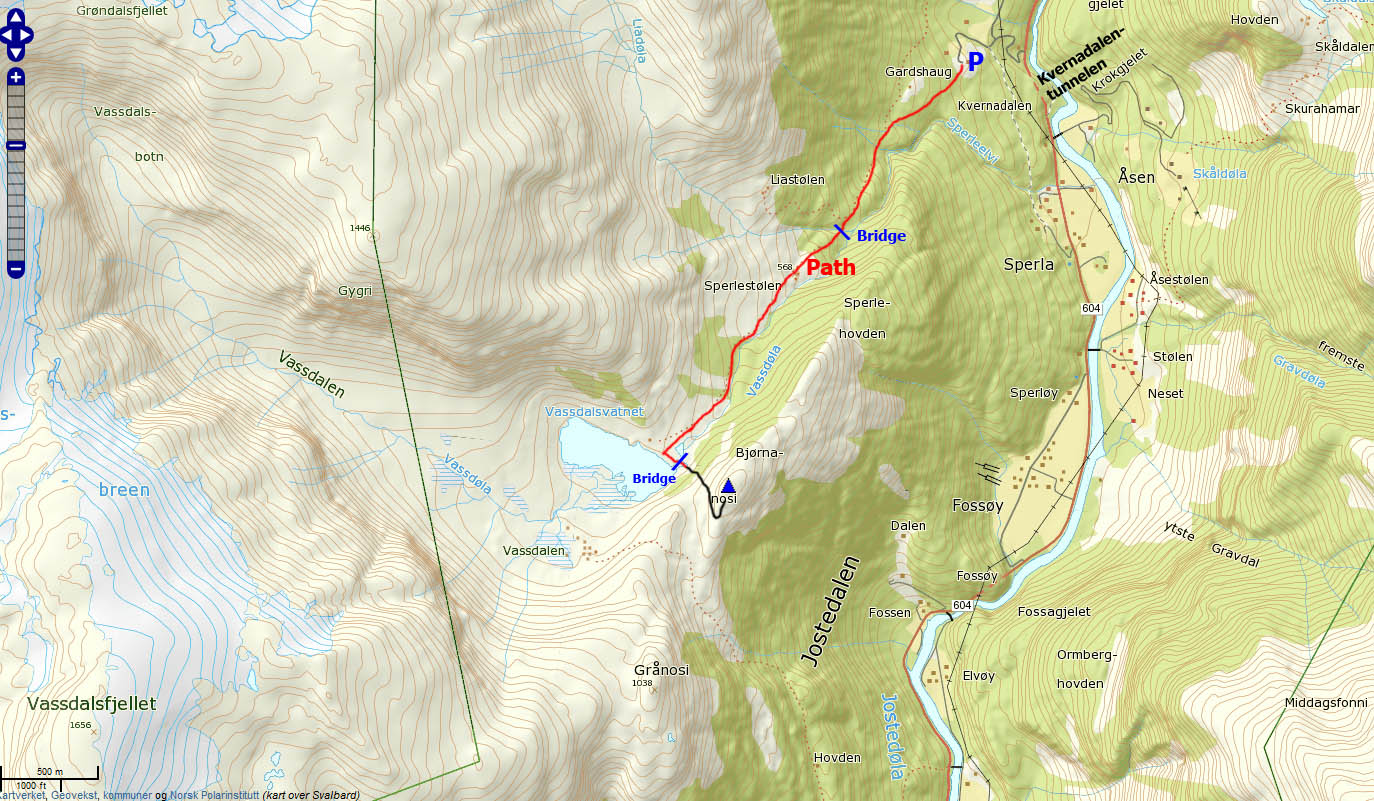
This route description begins at RV55 at Gaupne (Lustrafjorden). Take the road to Jostedalen (N61.40130 E7.28660) and follow it for 22,7km. You've now just passed Kverndalentunnelen tunnel. Take the first road (gravel) to your left (N61.57129 E7.28880). Follow this road for 350 meters to a fork. Stay left and drive 400 meters up to Gardshaug (N61.57042 E7.28276). Ask for permission to park if needed...
The route:

The route © Google Earth
(Click for larger image)
Follow the path into the forest (southwest direction). After a while, the ridge towards Bjørnanosi comes into view. The path is visible all the way to Vassdalsvatnet. Points along the way are:
- (N61.56836 E7.27908) After 300 meters, you pass the Sperle/Gardshaug trail fork.
- (N61.56170 E7.27326) You cross the river Liadøla on a bridge.
- (N61.55960 E7.26932) You pass Sperlestølen.
- (N61.54974 E7.25960) At
Vassdalsvatnet,
you cross the river
Vassdøla on an old iron
bridge.
Once across the bridge, prepare to go off-trail up to the summit. Head directly towards the summit and locate a neat passage (you can only see it up close) up among the cliff-band below the summit. The high point (N61.54900 E7.26481) is not marked.

Vassdøla seen from Sperlestølen
(Click for larger image)
 westcoastpeaks.com
Other Sogn og Fjordane mountains
Other Norwegian mountains
westcoastpeaks.com
Other Sogn og Fjordane mountains
Other Norwegian mountains