
Norwegian Mountains, Sogn og Fjordane
Bolberg, 337m (Haugen)
| Fylke/Kommune : | Sogn og Fjordane/Gloppen | ||
| Maps : | 1218-I Nordfjordeid (Statens Kartverk, Norge 1:50 000) | ||
| Primary factor : | 139m | ||
| Hiked : | Aug 2010 | ||
| See also : |
| ||
| See also : | Other Sogn og Fjordane mountains |

Bolberg
(Click for larger image)
Introduction
If you're passing Sandane - on the way to somewhere and thinking about stretching your legs, then a hike up to Bolberg can be a good choice. The hike is short, and 99% of it runs along a forest road. The reward is a nice view towards a section of the Nordfjord.

Nordfjord view from Bolberg
(Click for larger image)
Primary factor:
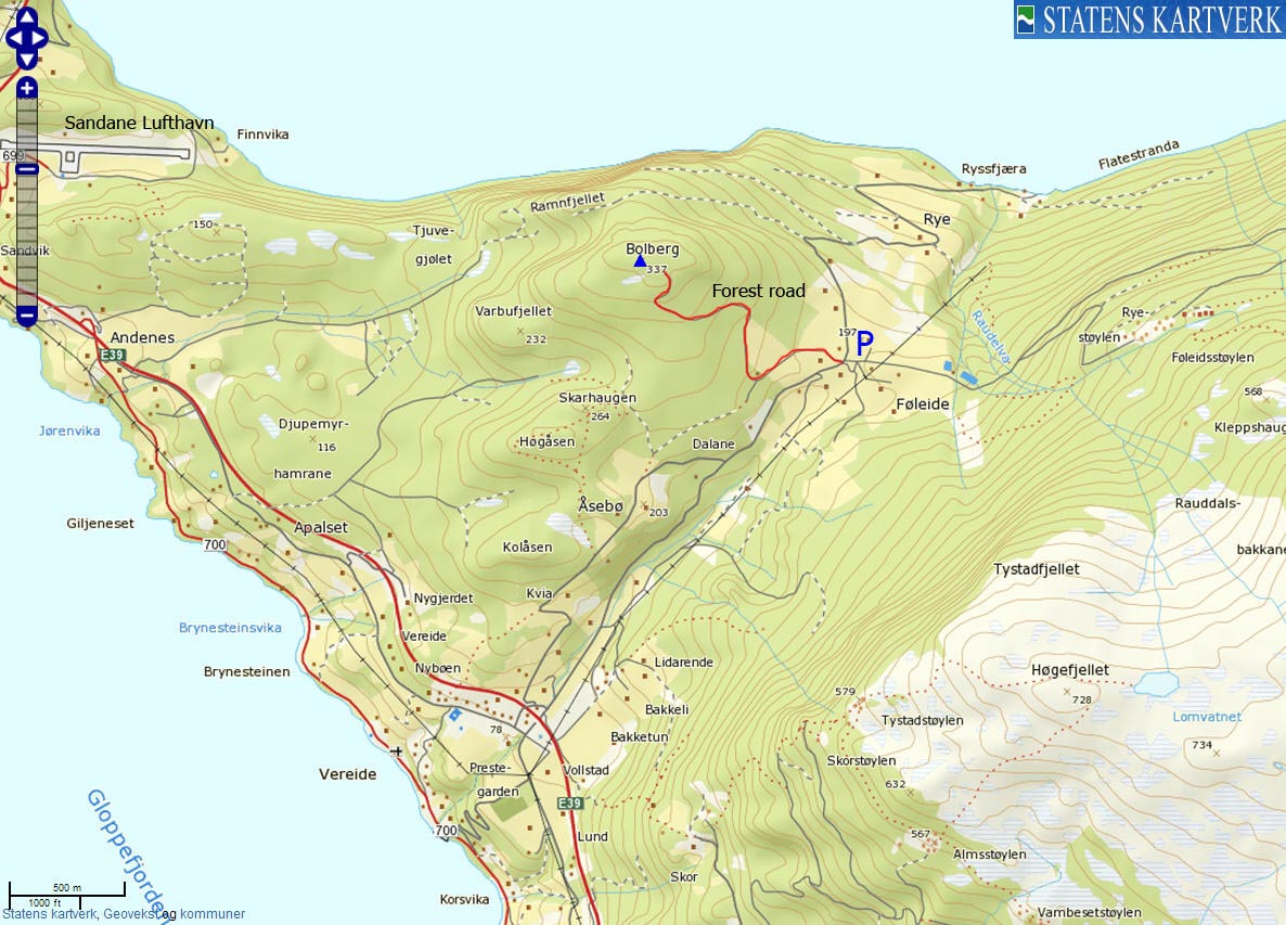
Bolberg (Norge 1:50,000: 337m, Økonomisk Kartverk: -, UTM 32 V 350323 6858436) has a primary factor of 139m towards the higher parent mountain Haugsvarden (862m). The defining saddle (approx. UTM 32 V 351164 6858090) is found at Føleide. Ref. Økonomisk Kartverk (5m contours), the saddle is within the range 195-200m, interpolated to 198m.

Føleide
(Click for larger image)
Google map
Google's interactive map. You can zoom, pan and click on the markers.
|
|
|

Trail descriptions
| This disclaimer is regarding all of the literature and instructional guides posted on the westcoastpeaks.com website. These instructions are guidelines only, and should not be used in lieu of common sense or judgement when attempting any of the actions involved or instructed. Westcoastpeaks nor myself will not be liable nor will it indemnify any form of compensation to anyone who has injured, harmed or even killed themselves or others while following any of the instructions written within the website. It should be noted by any persons willing to undertake any of the instructions provided that mountains offer varying levels of risk, regardless of size or incline. Risks to be considered are as follows but not limited to: wild animals, weather, the terrain, bad judgement, inappropriate or insufficient equipment, improper training or experience and of course, bad luck... |
The route descriptions are valid per Oct
2010.
|
Route 1: Føleide - Bolberg (all seasons)
|
|


Access
(all distances are approx. distances)
The starting point for this route description is Sandane. Follow highway E39 to the east (Sandane Lufthavn / Lote / Nordfjordeid). Approx. halfway between Sandane and Anda (ferry), turn right towards Vereide (signposted). Follow this road 2,2km up to Føleide. Locate the forest road (N61.82593 E6.17463) to Bolberg and find parking nearby.
The route

The road to Bolberg
(Click for larger image)
The route to the top is easy; follow the road upwards until it ends - and then follow a path the few meters up to the summit point - marked by antennas.

A Bolberg moment
(Click for larger image)
 westcoastpeaks.com
Other Sogn og Fjordane mountains
Other Norwegian mountains
westcoastpeaks.com
Other Sogn og Fjordane mountains
Other Norwegian mountains