
For Information, maps, trailhead and route descriptions, click HERE.
Sunday, and my on-duty week was over. The weather wasn't all that great, so I decided to just go for a fairly short hike. Ytstevasshornet seemed like an easy top to reach, and in the case of rainshowers, it would be a quick descent. A buddy of mine suggested I should go for the four-top roundtrip around Lake Tindeskardvatnet. I had already considered the option, but decided that I would go for Ytstevasshornet this time.
Ytstevasshornet
The dog and I left the Svartevatnet trailhead 11:46AM. After walking 15 minutes, the dog carried out his usual sit-down ritual. I didn't bother to argue with him, and put him in the backpack. He seemed happy about the outcome, and not a sound came from the backpack during the ascent. I followed the mountain path up to a small lake at approx. 930m, then turned right and headed off-trail, westbound towards Ytstevasshornet. My camera bounced into a rock, and the lens-cap fell in-between some rocks. I decided that I really wanted this cap, and dug rocks for about 10 minutes, until the cap was recovered. After a somewhat boring walk across boulder, I reached Ytstevasshornet 13:25PM.
After taking pictures, going back home didn't feel right. The rainshowers that kept sweeping across the Råna massif only produced light vapor on Ytstevasshornet. I decided that I should visit Dalmannshornet before calling it a day.
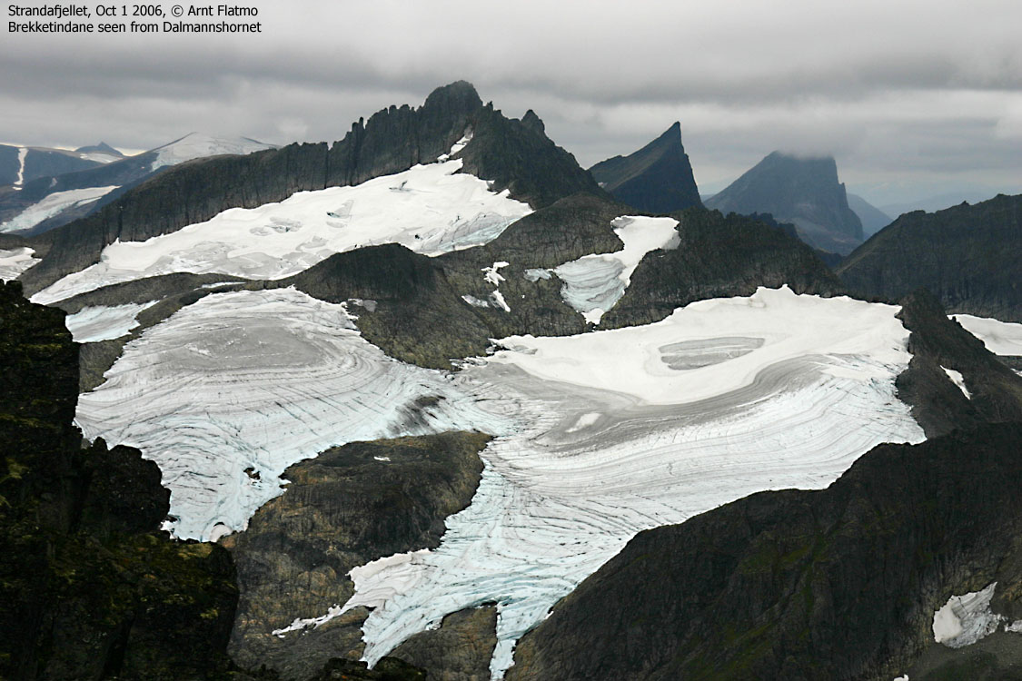
Dalmannshornet
The hike to Dalmannshornet was uneventful until I reached the ridge west of Kollskardet. There was moss on the rocks, and they were slippery as ice. Although the terrain was easy enough, the severity level was raised one notch, or two. Better not fall here. Higher on Dalmannshornet, the rocks were dry and walking was easy. I reached the top of Dalmannshornet 14:35PM. And no sounds could be heard from the backpack...
Dalmannshornet was a great viewpoint, and the view towards Brekketinden, Slogen and Jakta, stacked behind one another, was a great view. Pity that the weather was gloomy, and Jakta partly hidden in clouds. I had a wild landscape between myself and Brunstaddalen. Steep faces and numerous pinnacles. What a sight!
Tinden and Tuvegga
I wasn't too keen on descending Dalmannshornet the way I came, due to the slippery rocks. Then I figured that going home via Tinden and Tuvegga wasn't that much of a detour. I descended Dalmannshornet across gentle boulder and on snow/ice. On my way up to Tinden, I ran into another section of slippery rocks. As I was ascending, this was not a big problem, but I hoped that the descent route did not have too many of these rocks. I reached the top of Tinden 15:40PM, took a couple of pictures and moved on.
Troll had still not made one sound, and I suspected that he was sleeping back there. The descent from Tinden was steep, but there were no slippery rocks, and no problems. As the plan was to only hike Ytstevasshornet, I had brought no food and no water. I was fairly thirsty by now, and hadn't passed running water since I left the river below Ytstevasshornet. I didn't really want to, but had to drink still water in order to still enjoy the day.
After reaching Tuvegga summit 16:25PM, I had ascended 1470 vertical meters. I was glad there were no more tops around this lake, and looked forward to the descent and running water. I let Troll out of the backpack, and assumed that he would walk all the way back to the car.
And so he did, even in the steep section along the river. But only because someone had done a tremendous job in building a rocky stairway in the mountainside. The dog always seems truly happy upon descent, and sometimes he resembles a rabbit. That's why I refer to him as the "downhill dog". We returned to the car 5,5 hours after leaving it. It is not often that I get to do 4 independent peaks in one trip, and that was what saved the day. There was a big lack of "moments", the weather was gloomy, and I had been thirsty for too long. I treated myself with a soda and a hot-dog while waiting for the ferry at Ørsneset, and called it a good day after all.
To Ytstevasshornet


360 deg. wide-angle view from Ytstevasshornet

50mm views from Ytstevasshornet


Other pics from Ytstevasshornet


To Dalmannshornet


360 deg. wide-angle view from Dalmannshornet

Other pics from Dalmannshornet


To Tinden


Tuvegga ++


No Javascript:
1 2 3 4 5 6 7 8 9 10 11 12 13 14 15 16 17 18 19 20 21 22 23 24 25 26 27 28 29 30 31 32 33 34 35 36 37 38 39 40 41
 westcoastpeaks.com
Other Møre & Romsdal mountains
Other Norwegian mountains
westcoastpeaks.com
Other Møre & Romsdal mountains
Other Norwegian mountains