
|


Engsetfjellet is Frostadtinden's smaller neighbour, and can easily be reached from the Storsætra trailhead (same trailhead as Frostadtinden). There are other routes to the mountain, but this is perhaps the best route for skiing, and this is the route described on this page.
Although the views from Frostadtinden are better, the views from Engsetfjellet won't disappoint you. The top is *much* less visited than Frostadtinden, so if you want solitude, this may be the place to go.
The summit has two tops, where the easternmost is slightly higher than the westernmost point (535m), holding the trig. point. Without a precise measurement, this page operates with 535m as the height.
Engsetfjellet (M711: 535m, Ø.K.: 534,58m, UTM 32 V 385328 6935976) has a primary factor of 227m towards the higher parent mountain Blåskjerdingen (1069m). The defining saddle (approx. UTM 32 V 387570 6936392) is found by Deplane. Ref. Økonomisk Kartverk (5m contours), the saddle is within the range 305m-310m, interpolated to 308m.
Notes: Class ratings are in reference to YDS. Click here for more information.
The trails described below are not necessarily the *easiest* trails to this mountain.
|
Storsætra (Engsetdalen) - Engsetfjellet (winter)
|
|
Access
From Ålesund, follow highway E39 towards Åndalsnes. From the E16/E39/Olsvika roundabout near Breivka, follow E39 13,3Km. Turn left onto highway RV661 (Skodje/Brattvåg/Vatne). Pay toll at an unmanned toll booth (coins + credit cards) 1,5Km later. 6,9Km after you left E39, turn right towards "Engsetdal".
Follow the Engsetdalen road 5,4Km, and turn left towards "Storsætra". Provided the road is open, you can drive 2,6Km up to the winter parking. In summer, you have to pay a fee (self-serviced toll booth) to drive further up this road.
The route
Follow the road upwards 900m (turn right in the first road junction), and all the way to the cabins at Deplane. Do not turn left on the Frostatinden route shortly after crossing Skålselva river. At Deplane, turn right and leave the road when you reach the open fields. Keep right of the ditches and aim for Engsetfjellet's eastern ridge. The ridge is straightforward and contains no surprises.
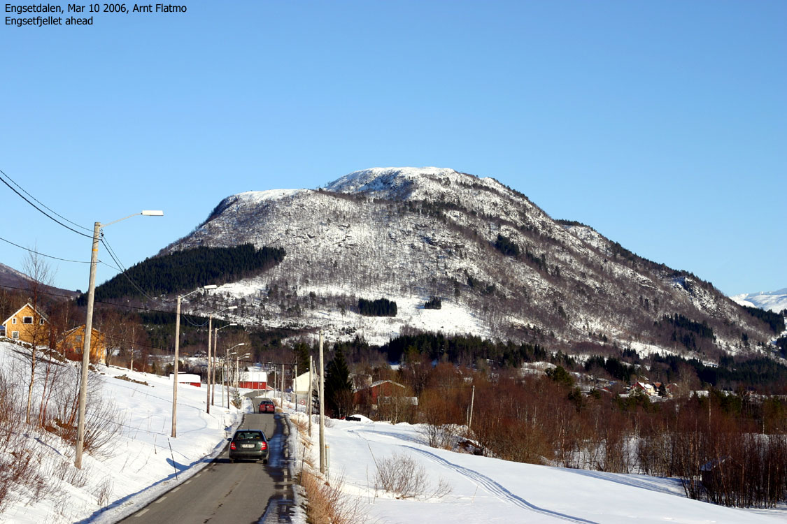
The weather this Friday was downright stunning, and I decided to visit Engsetfjellet in the afternoon. Three factors were important; a) I would be able to get down before dark, b) I knew the trailhead, having visited Frostadtinden last week-end and c) it was the only top in Skodje kommune that I hadn't been to. I left work one hour early and was ready to leave Storsætra trailhead 15:50PM.
My dachshund "Troll" has been spoiled at his old age, and only wants to walk downhill. As such, the backpack was quite heavy. In addition to the dog, I carried a large blanket (for him), and clothing for full winter. It was quite cold. Approx minus 6 degrees plus wind at the trailhead. Plus camera equipment, and so on.
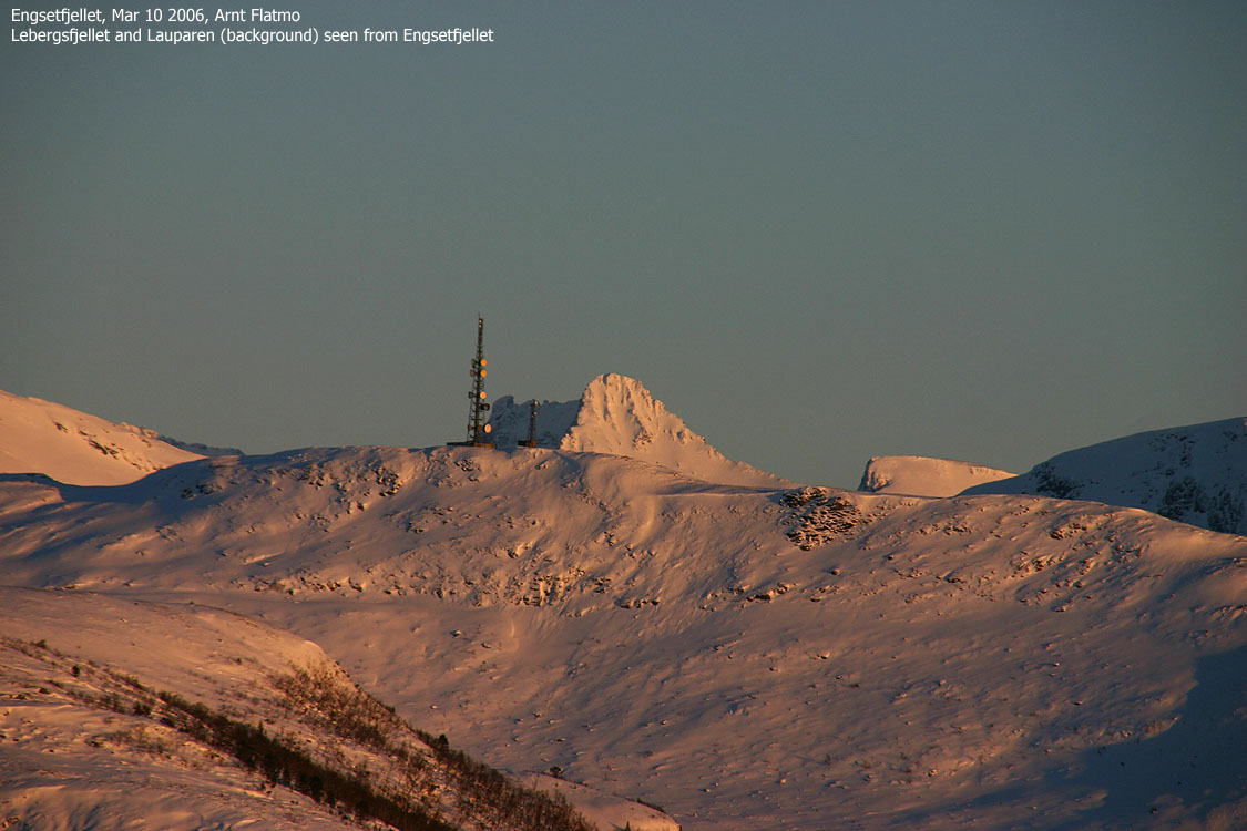
I left the trailhead 16:00PM and had nice flow on the prepared trail towards Deplane. At Deplane, I had to break trail all the way to the top, but skiing was pleasant in the powder snow. The colors of the Ørskogfjellet mountains grew more and more beautiful by the minute and I wondered why I didn't go skiing in the sunset more often.
I reached the top 17:25PM and only stayed for the pictures. Troll had no particular desire to get out of the backpack, but agreed to pose on a picture. The wind was cold and I turned around rather fast. I signed the visitor register before I left. The previous visitor had signed in Jan 28 2006. This wasn't a crowded mountain. Back at Deplane, I let Troll out of the backpack. The road didn't quite qualify as downhill, but he had enough of the backpack and ran like crazy the remaining 3Km back to the trailhead.
18:35PM, I reached the trailhead, a little ahead of Troll. When he arrived, he didn't see me, although I was only 30m away. He looked confused. After a few seconds, I called on him. He looked back up the forest road and took off. I yelled to no avail, and had to run after him. I wondered if he had turned deaf and senile as this was a new type of behaviour. I caught up with him when he sat down. I was 5 meters away and talked to him. He took off again and I had to come running after. I wondered if we had to do this mountain one more time, but finally I was able to catch up with him. He seemed very surprised that I was behind him, but now that everything was OK, he took off and ran away from me again. This time, fortunately, towards the car.
To Engsetfjellet


Wide-angle panoramas from Engsetfjellet, 2 parts


50mm panoramas from Engsetfjellet, 3 parts


Zoom panoramas from Engsetfjellet


Other summit pictures + descent


No Javascript:
1 2 3 4 5 6 7 8 9 10 11 12 13 14 15 16 17 18 19 20 21 22 23 24 25 26 27 28 29 30 31
 westcoastpeaks.com
Other Møre & Romsdal mountains
Other Norwegian mountains
westcoastpeaks.com
Other Møre & Romsdal mountains
Other Norwegian mountains

