
Norwegian Mountains, Sogn og Fjordane
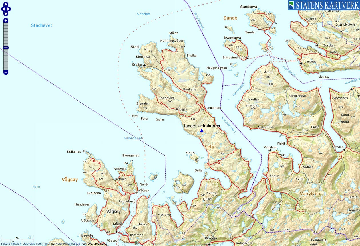
Stadlandet
Geitahornet, 475m
| Fylke/Kommune: | Sogn og Fjordane county/Selje municipality | ||||||||||
| Maps: | 1119-III Vanylven (Statens Kartverk, Norge 1:50 000) | ||||||||||
| Primary factor: | 137m | ||||||||||
| Hiked: | Feb 2012 | ||||||||||
| See also: |
| ||||||||||
| See also : | Other Sogn og Fjordane mountains on westcoastpeaks.com |

Geitahornet
(Click for larger image)
Introduction
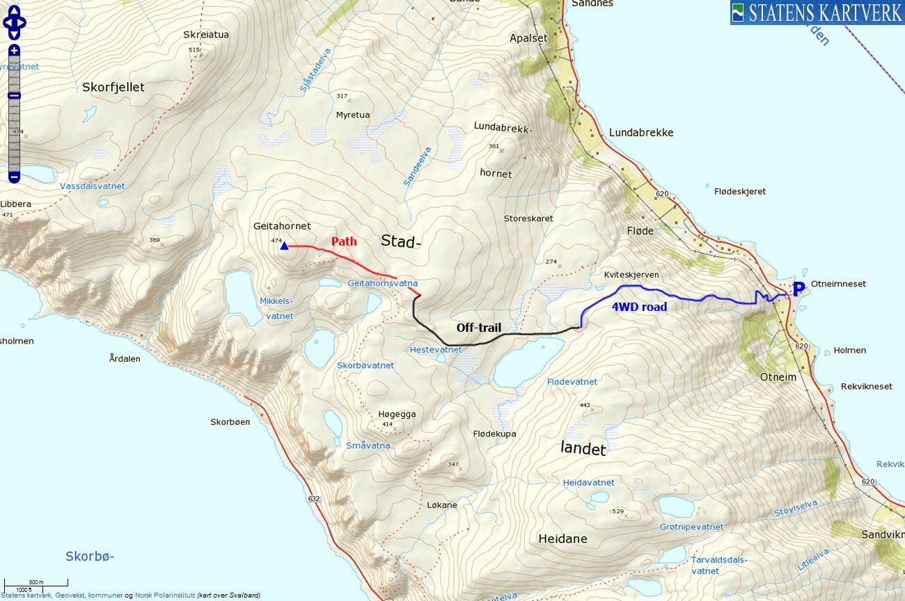
The mountain tops Skreiatua, Geitahornet and Tarvaldsegga are located between the Drageskaret and Sandvikseidet mountain passes on Stadlandet. Geitahornet is found in the middle and is normally hiked from Drageskaret or from Leikanger. This page will however describe a route (partly off-trail) from Otneimsneset via Flødevatnet.

Geitahornet and other Stadlandet tops
(Click for larger image)
Primary factor:
Geitahornet (Norge 1:50,000: 474m, Økonomisk Kartverk: 475m contour, UTM 32 V 307523 6889465) has a primary factor of 137m towards the higher parent mountain Skreiatua (515m). The defining saddle (approx. 32 V 307051 6890279) is found between these two tops. Ref. Økonomisk Kartverk (5m contours), the saddle is within the range 335-340m, interpolated to 338m.

Geitahornet
(Click for larger image)
Google map
Google's interactive map. You can zoom, pan and click on the markers.
|
|
|

Trail descriptions
| This disclaimer is regarding all of the literature and instructional guides posted on the westcoastpeaks.com website. These instructions are guidelines only, and should not be used in lieu of common sense or judgment when attempting any of the actions involved or instructed. Westcoastpeaks nor myself will not be liable nor will it indemnify any form of compensation to anyone who has injured, harmed or even killed themselves or others while following any of the instructions written within the website. It should be noted by any persons willing to undertake any of the instructions provided that mountains offer varying levels of risk, regardless of size or incline. Risks to be considered are as follows but not limited to: wild animals, weather, the terrain, bad judgment, inappropriate or insufficient equipment, improper training or experience and of course, bad luck... |
|
Route 1: Otnemsneset - Flødevatnet - Geitahornet (summer/autumn)
|
|


This route description is valid per Feb 2012
Access
(all distances are approx. distances)
The starting point for this route description is the place Åheim by Vanylvsfjorden.
At the Stadlandet/Måløy junction (signposted) south of the river, follow RV620 towards Stadlandet. Drive this road 7,4km to the Selje/Stadlandet junction (signposted) above Kjødspollen. Turn right towards Stadlandet/Vestkapp and drive 10km to the Selje/Stadlandet junction (signposted) at Sandvika. Turn right towards Stadlandet/Vestkapp) and drive 3,1 to the Ervik Havfiske building on your right-hand side. Find parking here (N62.08992 E5.39098).
The route:

The route, as seen in Google Earth
(Click for larger image)
Cross the road and locate the mountain road that begins at a gate. Follow the road 2,1km up to Flødevatnet. The road ends here (N62.08529 E5.35926). It's a 4WD road, but it's not a road I would recommend anyone to drive.
Go off-trail and follow the boggy (and aggravating) terrain on the north side of Flødevatnet, in the direction of Hestevatnet (N62.08201 E5.34011). Continue northwest up to Geitahornet's east ridge. The unmarked high point (N62.08806 E5.31312) is found 66m north of the large cairn (N62.08747 E5.31314).
Alternative route: At Flødevatnet, follow path to Lundabrekkhornet (signposted) and then follow the ridge up to Geitahornet. This could be an easier route than the bog terrain next to Flødevatnet.
Pictures and Trip reports:
- Geitahornet, Feb 18 2012
- Geitahornet seen from other mountains
 westcoastpeaks.com
Other Sogn og Fjordane mountains
Other Norwegian mountains
westcoastpeaks.com
Other Sogn og Fjordane mountains
Other Norwegian mountains