
|


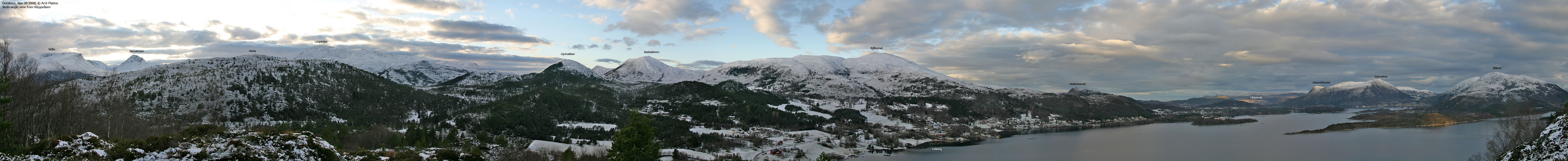
Gyrinakken is a fairly modest hill, located on Gurskøya island. More precisely near Leikongeidet, and the Sande/Herøy kommune border runs across the summit. The top is trivial to reach (20 minutes) from the road at Leikongeidet, and you will find an antenna on the top.
You may also head up from the valley where the Jøsokelva river runs, but this web page only describes access from the RV61 road.


Gyrinakken (Norge 1:50,000: 362m, Økonomisk Kartverk: highest contour is 365m, UTM 32 V 330940 6904197) has a primary factor of 157m, towards the higher parent mountain Røddalshorn (560m). The saddle (approx. UTM 32 V 330181 6904205) is found on Leikongeidet. Ref. Økonomisk Kartverk (5m contours), the saddle height is in the range 205-210m, interpolated to 208m.
Personal GPS measurement read 371m on top of the cairn, approx. 2m high.
Google's interactive map. You can zoom, pan and click on the markers.
Notes: Class ratings are in reference to YDS. Click here for more information.
The trails described below are not necessarily the *easiest* trails to this mountain.
|
Leikongeidet - Gyrinakken (all seasons)
|
|


Access
(all distances are approx. distances)
The nearest larger city is Ålesund. From Ålesund, follow highway E39 towards Bergen, and then RV61 towards Hareid. Take the Sulesund - Hareid ferry.
Entering Hareid, you pass through a roundabout. Follow RV61 and drive 16,8Km (you pass Ulsteinvik along the way). In the RV653/RV61 junction, turn right towards Måløy/Fosnavåg. After 2,9Km, RV61 makes a sharp left turn, while RV654 continues straight ahead. Turn left on RV61. After 7Km, you're at Leikongeidet. Locate the Gyrinakken trailsign just before the road begins to desend towards Gursken. There is room for one car here. Alternatively, there is a parking area further northeast (you've passed it already).
The route
Per May 2007, there was construction going on where the path went. In any case, aim for a gully that leads up towards Gyrinakken. The (vague) path runs on the right-hand side of this gully. Follow it upwards, then across a small meadow, pass the antenna near the top and head up to the summit cairn. You may find a visitor register inside a mailbox.


No Javascript:
 westcoastpeaks
Other Møre & Romsdal mountains
Other Norwegian mountains
westcoastpeaks
Other Møre & Romsdal mountains
Other Norwegian mountains

