
Norwegian Mountains, Sogn og Fjordane
Stadlandet
Heidane, 530m (Storehornet)
Høgegga, 414m (Kongereggja)
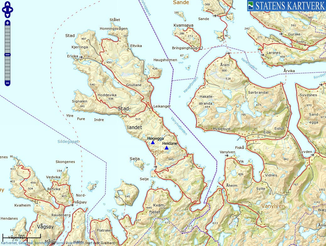
| Fylke/Kommune: | Sogn og Fjordane county/Selje municipality | ||||||||||
| Maps: | 1119-III Vanylven (Statens Kartverk, Norge 1:50 000) | ||||||||||
| Primary factor: |
Heidane: 88m Høgegga: 56m | ||||||||||
| Hiked: | Mar 2012 | ||||||||||
| See also: |
| ||||||||||
| See also : | Other Sogn og Fjordane mountains on westcoastpeaks.com |

Høgegga and Heidane seen from Selje
(Click for larger image)
Introduction
Heidane and Høgegga are two tops between the mountain passes Sandvikseidet and Dragseidet on the Stadlandet peninsula. These tops are slightly less prominent as their neighbors Tarvaldsegga, Geitahornet and Skreiatua (Sjåstadvarden), but the view from Stadlandet is nice - independent of where you are.
These two tops can be reached from Flødevatnet. See the route description for Geitahornet if you would like to hike from Otneimneset. This page will describe a route from Liset (north of Selje - see the above picture) and this is probably overall the best route.

Heidane
(Click for larger image)
Primary factor:
Heidane (Norge 1:50,000: 529m, Økonomisk Kartverk: 530m contour, UTM 32 V 310473 6887570) has a primary factor of 88m towards the higher parent mountain Tarvaldsegga (645m). The defining saddle (approx. 32 V 311265 6887501) is found between these two tops. Ref. Økonomisk Kartverk (5m contours), the saddle is defined through a fixed point - 441,5m ~ 442m.
Høgegga (Norge 1:50,000: 414m, Økonomisk Kartverk: 413,87m, UTM 32 V 308557 6888088) has a primary factor of 56m towards the higher parent mountain Geitahornet (475m). The defining saddle (approx. 32 V 308360 6888917) is found south of Geitahornsvatna. Ref. Økonomisk Kartverk (5m contours), the saddle is within the range 355-360m, interpolated to 358m.

Høgegga
(Click for larger image)
Google map
Google's interactive map. You can zoom, pan and click on the markers.
|
|
|

Trail descriptions
| This disclaimer is regarding all of the literature and instructional guides posted on the westcoastpeaks.com website. These instructions are guidelines only, and should not be used in lieu of common sense or judgment when attempting any of the actions involved or instructed. Westcoastpeaks nor myself will not be liable nor will it indemnify any form of compensation to anyone who has injured, harmed or even killed themselves or others while following any of the instructions written within the website. It should be noted by any persons willing to undertake any of the instructions provided that mountains offer varying levels of risk, regardless of size or incline. Risks to be considered are as follows but not limited to: wild animals, weather, the terrain, bad judgment, inappropriate or insufficient equipment, improper training or experience and of course, bad luck... |
|
Route 1: Liset - Heidane - Høgegga round trip (summer/autumn)
|
|


This route description is valid per Mar 2012
Access
(all distances are approx. distances)
The starting point for this route description is the place Selje.
Take the road to Skårbø (signposted). Drive 2,1km to Liset and find parking (N62.06102 E5.34161) on the right-hand side of the road, before the river.
The route:

The route, as seen in Google Earth
(Click for larger image)
Cross the river and locate the Geitahornet & Høgegga signposts in front of the nearest house. After you've passed the first house, turn right and locate a stick with a cross. Follow the path upwards and close the gate(s) behind you. Even if you're walking on grass, the terrain is "rocky", with stone fences, stone cabins and stone cairns (see the below picture).
When you reach the boggy plateau above (Løkane), the path runs to the north and up to Høgegga's east ridge. The route is marked all the way to the top of Høgegga (N62.07625 E5.33435) - marked by a medium-sized cairn.
Go back 0,3km in the direction you came, then leave the path and continue east into the pass between Høgegga and Heidane. Hike up Heidane's west ridge (vague path) and locate the summit east of Heidavatnet - marked by a medium-sized cairn (N62.07257 E5.37151).
Follow Heidane's southwest ridge (off-trail) back to your ascent route.

A good viewpoint above Liset
(Click for larger image)
Pictures and Trip reports:
 westcoastpeaks.com
Other Sogn og Fjordane mountains
Other Norwegian mountains
westcoastpeaks.com
Other Sogn og Fjordane mountains
Other Norwegian mountains