
|

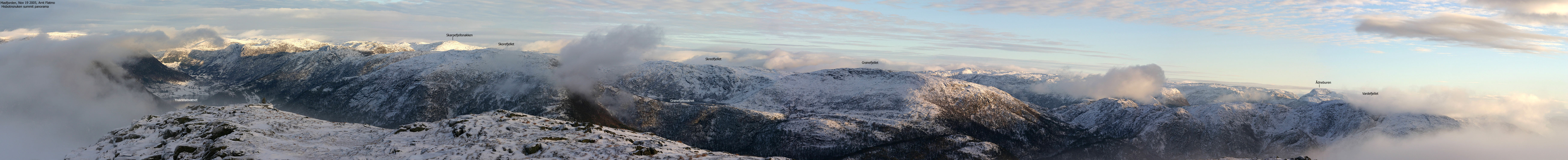
Hisbotnsnuken is located on Gulenhalvøya (Gulen peninsula) and is part of a mountain range that separates Sogn and Fjordane and Hordaland fylker (counties). The mountain has a trig. point (Svadfjell, 594m) on the south side of the summit plateau. The high point (620-624m, interpolated to 622m) is located 560m further northeast. This is a good viewpoint, although the slightly higher Øksefjellet further north would be a better one. You can easily identify the characteristic Lyderhorn (Bergen) 60Km further south, in addition to the Rundemanen tower. Another tower - Brossviksåta - is seen to the northwest, with Sognefjorden beyond.
Hisbotnsnuken marks the southeast corner of the vast Gulen mountain area, as defined by the Hosteland - Brekke road. The mountain has its name from Hisbotnen - in the valley between Hisbotnsnuken and Gulbrekkfjellet. There are several ways to ascend Hisbotnsnuken, and this web page describes an approach from Lindebotnen. This is a "fun" mountain and is absolutely worth a visit.
Hisbotnsnuken (M711: highest contour is 620m, Ø.K: highest contour is 620m, ~ 622m) has a primary factor of 169m towards the higher Øksefjellet (647m) The saddle is found in Svartetjørnskardet (Ø.K.) between the tops. Ref. Økonomisk Kartverk (5m contours), you cross the 455m contours on the high route, but not 450m. The saddle height has been interpolated to 453m.
Over a 5-minute period, I measured (GPS) the high point (32 V 298094 6758639) to 627m (no correction for error margin).
Notes: Class ratings are in reference to YDS. Click here for more information.
The trails described below are not necessarily the *easiest* trails to this mountain.
|
Lindebotnen - Hisbotnsnuken (all seasons)
|
|
From Bergen, you have two main alternatives;
a) w/ferry (Leirvåg - Sløvåg)
From Bergen, follow highway E39 northbound. After the Nordhordlandsbrua bridge,
pay (NOK 45,- for passenger cars per May 2005) at the Toll station. Drive 2,4Km
and turn left onto highway RV57 (Leirvåg). Follow RV57 36,6Km, then turn
right right towards "Leirvåg". The ferry to Sløvåg is 1,4Km
from this exit. Note that the ferry sometimes stop by Skipavik, west of Sløvåg.
Per July 2005, the ferry schedule was published on
ruteinfo.net.
From Sløvåg, continue 3,9Km. Turn right onto RV57 towards Duesund. Follow this road 9,6Km (to Hosteland) and turn left towards Brekke (see below for further driving instructions)
Another ferry alternative is Masfjordnes - Duesund. A scenic, but not the fastest or shortest route.
b) Via Kringla:
From Bergen, follow highway E39 northbound. After the Nordhordlandsbrua bridge,
pay (NOK 45,- for passenger cars per May 2005) at the Toll station. Drive 66(++)Km
and at the Kringla junction, turn left towards Solheim/Duesund. Continue on this road
for 5,5Km and turn right towards Duesund. Drive 13,3Km (incl. along Masfjorden) and
turn right towards Rutledal.
Turn right and continue approx. 3,6 to the Brekke junction (Hosteland). Turn right here.
See below for further driving instructions.
(Another alternative is to drive along Haugsværfjorden via Solheim).
Road to Brekke
Follow the road to Brekke approx. 7,1Km (go right at the Sleire junction along the way) and turn left onto a narrow (unsignposted) road that leads to Lindebotnen. Drive towards the farm (600m from the exit) and find parking without blocking traffic. If you get close to the farm, ask for permission to park.
Up the forest
First task is to get up to Brekkene, old buildings above Lindbotnen. There are several paths, but this is an easy forest. From Brekkene, the general rule is to head *upwards* and seek left or right depending on the obstacle. The general direction (until you get to higher ground) is north.
In detail, from the main Brekkene building, seek west towards the forest, then head north. You will soon see cliffs above you. Seek northeast (right) and find a small pass that takes you above the cliffs. You will then (probably) run into a path marked by ribbons, but you'll likely lose it just as fast.
Once above these cliffs, you see more cliffs above you. Turn left (west) and head up a smooth-rock plateau (towards Grønetuva). Turn right (towards the ridge) when you find it logical and you will see a visible path.
Now that you are on the ridge, the rest is obvious. You will be able to follow the path up to 500m elevation. When you have the upper Hisbotnsnuken ridge in view, ascend on the west side (closest to the steep drop to your left). From a distance, this may seem airy, but everything gets easier as you get close. After a short hike upwards, you are now on Hisbotnsnuken trig. point - 594m. The trig. point has fallen.
Proceed 600m northeast to the summit, marked by a single rock. Descend your ascent route.
|
Trip report Nov 19 2005
In the morning.. I always thought the dog wakes me up at 07:00AM in the week-ends because he needs to go outside. As he rather preferred to lay on the warm bathroom floor this Saturday morning, I suspect that he thinks we are about to oversleep for work. In any case, I migrate from unconscious to awake during this week-end ritual. Normally, I wake HIM up 06:30AM the rest of the week.. Somehow, he knows Mondays. 15 minutes before the weekly conference call, he whines outside the meeting room door. My cold had developed into a serious flu during the week, and my plan was to sleep as long as my body would let me. I forgot to take the dog into consideration. Wide awake, 07:10AM, I hit the shower feeling quite awful. I had gone to sleep with a wet towel the night before. Whether I actually had the fever or not, is hard to say. There's little I hate more than being sick in the week-end. This morning, I actually felt too sick to stay home. I figured a mountain would do me good, and as I am attempting to finish the Masfjorden mountains before I leave Bergen, I decided to put Hisbotnsnuken on the agenda for the day. Getting there was a long drive. With my body full of pain killers, I went out to acclimatise to winter roads. E39 was OK, but the country roads were icy. The road from Hosteland to Lindebotnen was insanely icy, and the car went back and forth across the road.
The local farmer I drove to Lindebotnen (a single farm) and met the farmer and his wife. They were curious as to why I was heading up Hisbotnsnuken. I explained that I was collecting Hordaland mountains. The farmer wondered, since I was all by myself, how I could PROVE that I actually had been to the summit. I responded that I was bringing a digital camera and had a web-site. The farmer shook his head. This wasn't good enough. He was reluctant to let me up the mountain, as deer hunters were on the way. I responded that hunters and hikers have to develop a mutual understanding and co-existence. There is no way that I stay out of the mountains from September to December because of the hunting season. The farmer suggested that I should visit Grønefjellet instead, as 5-6 sheep were missing for some reason. His wife came to my rescue and convinced him that the deer would be down in the forest (because of the snow) and not on the mountain. The farmer was concerned that the hunters would gun me down. He wasn't too worried about the older, experienced hunters. But more about the young and eager ones. I lied to him and told him that I would wear a red hat. The farmer was also concerned about the snow depth, the cliffs and the mountain altogether. I explained that I was quite experienced and that I didn't expect any particular problems. He was also concerned about me getting lost, but concluded that I should be able to backtrack in the snow. I told him about the GPS, but he wasn't impressed. I left the Lindebotnen trailhead 12:40PM, carrying my dog in the backpack. The farmer was concerned when he saw the dog and told me that I had to put a leash on him. I told him not to worry, as I would carry him. I didn't bother explaining that the snow depth was roughly the dog's height and the fact that there were no lambs or sheep around. Regarding deer, well, I think the deer would have been quite safe. Moreover, the dog leash law period for Masfjorden kommune ended November 1st.
Ascent Getting up the ridge was fairly trivial. The forest above Lindebotnen was open and the small amount of bush didn't cause any problems. Once on the ridge, the hike up to the summit was trivial, although the snow depth was noticeable at times. I had been under the impression that the summit was at 594m elevation, but discovered along the way that there was a higher point 600m towards the north. I reached the summit 14:20PM, and it was altogether a beautiful day. Valley fog made the scenery even more beautiful. There was no wind on the summit, and the dog hadn't complained at all about staying in the backpack. I gave the dog the traditional lunch-box while I shot a round of pictures. We turned around fairly quickly. Daylight is scarce this late in the season.
Descent The dog walked most of the way down, with me breaking trail in front. I didn't even bother looking for a roundtrip route. We were back at the trailhead 15:40PM, and the farmer came by. I sensed a greater level of respect and we had a nice chat about the mountain. After changing into dry clothes, I drove to Sløvåg, waiting for the 16:50PM ferry. I had taken the long way around in order to get to the mountain, but had prepared (checking schedules) for a return via the Sløvåg - Leirvåg ferry. A very nice day in the Gulen/Masfjorden mountains had come to the end and I could yet again focus on the flu. The story all week has been that I've felt awful except when I've visited Mt. Ulriken in the afternoon. Fresh air obviously do me good. At least, I think it does...
|
Move cursor to read notes, and click on the images to see full version.
Some of the thumbnails may have been cropped to fit the format.
To Lindbotnen


Ascent


Summit views


Descent


No Javascript:
1 2 3 4 5 6 7 8 9 10 11 12 13 14 15 16 17 18 19 20 21 22 23 24 25 26 27 28 29 30 31 32 33 34 35 36 37


No Javascript:
Other hordaland mountains
 Other Masfjorden K. mountains
westcoastpeaks.com
Other Masfjorden K. mountains
westcoastpeaks.com

