
|


Kongsvollen is the highest mountain in Hareid kommune, and the 2nd highest mountain on Hareidlandet island. As the Hareid/Ulstein kommune border runs across the summit, Kongsvollen is also the 2nd highest mountain in Ulstein kommune, just succeeding the 14m higher Blåtind.
Refer to the Blåtind page for how to get to the Blåtind trailhead in Ringstaddalen. You can follow the Blåtind path up to Hundlaupsvatnet and then proceed up Kongsvollen's southwest ridge.
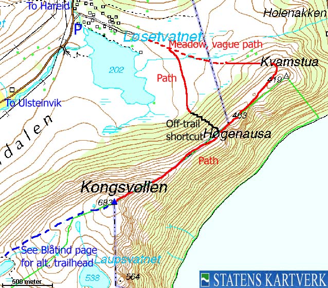
A much more fun route is described on this page. It starts by Lake Løsetvatnet and climbs onto Kongsvollen's north ridge. The upper part of this ridge is called "Bukketrappa". The name suggests that this is goat terrain, but the ridge is not difficult for the average hiker. A certain head for heights comes in handy when you pass the most narrow section.
In good weather, the north ridge is a splendid walk. You have Storfjorden down to the left, with the Ørsta mountains as a perfect background to the east. As you gain elevation on the ridge, you wonder how narrow this ridge really gets. And once on top, you can enjoy the view towards wild peaks, the ocean, the coastline, islands, bridges, places, and more.
Blåtind (M711: 683m, Ø.K.: 683,06m, UTM 32 V 341156 6910049) has a primary factor of 200m towards the higher Blåtind (697m). The saddle is found between the two tops, E of Lake Hundelaupsvatnet. Ref. Økonomisk Kartverk (5m contours), the saddle is within the range 481-485m, interpolated to 483m.
Notes: Class ratings are in reference to YDS. Click here for more information.
The trails described below are not necessarily the *easiest* trails to this mountain.
|
Løsetvatnet - Kongsvollen (summer/autumn)
|
|
Access
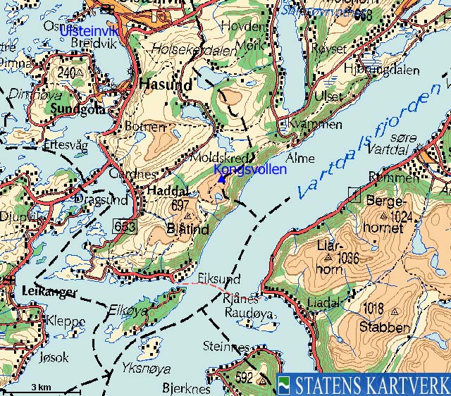
From Ålesund, follow highway E39 towards Bergen, and then RV61 towards Hareid. Take the Sulesund - Hareid ferry and follow RV61 (roughly) 3Km towards Ulsteinvik. At the roundabout junction outside Ulsteinvik, turn left and follow RV61 southbound. RV61 later turns right (SW) towards Måløy. At this junction, drive straight ahead and keep driving for approx. 1,3Km and turn left towards "Haddal".
Drive approx. 500m on the main road (which curves sharp to the right in the beginning) and turn left into "Ringstaddalen". Follow this road approx. 3,8m (the road turns to gravel road after 2,9Km) to a parking area. You will see the "Blåtind" trailsign on the left-hand side of the road. The parking slots are for the most part reserved, but you will find available pockets here and there. This is also the trailhead for Gardnestua and Løkeberget (the path begins a few meters up the road).
Alternative route from Hareid;
Follow RV61 6,5Km and turn left onto a gravel road just before the top of the hill. Follow this road (it is a bypass road, so turn left again after 500m) 6,3Km to the Løsetvatnet trailhead described above. This road is not plowed in winter, and opens when the snow has melted away.
The route
Follow the road towards the cabins. The road ends after 700m. Cross the meadow, aiming for the northernmost top (Kvamstua, 430m). You will probably think this is the only convenient route up to the ridge. Once on the ridge, follow the path across Høgenausa (462m) and up to Kongsvollen summit, marked by a cairn. You will find a summit logbook in a mailbox.
As mentioned, the upper part of the north ridge is called "Bukketrappa". While the path mainly runs on the south side of the ridge (giving you fjord views), stay in center of the ridge when you reach this section. I followed a path that took me on the north side of the ridge, and it got more exposed than necessary. A good route can be found on the center of the ridge.


 westcoastpeaks.com
Other Møre & Romsdal mountains
Other Norwegian mountains
westcoastpeaks.com
Other Møre & Romsdal mountains
Other Norwegian mountains

