
|


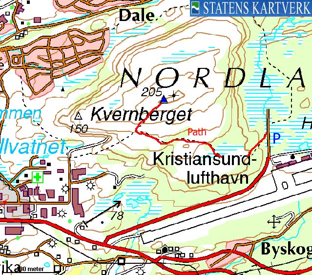
Kvernberget is the highest point on Nordlandet island, and also the high point in Kristiansund kommune. This is the Kristiansund city mountain, just like Aksla is for Ålesund and Fløyen for Bergen. As such, there is a number of paths leading to- and around the mountain. This page will describe a convenient path that runs from the airport - with the same name.
Because of its location near the ocean, the views from the top are quite good.
Kvernberget (Norge 1:50,000: 205m, Økonomisk Kartverk: 204,69m, UTM 32 V 439940 6999280) has a primary factor of 205m, being the high point on Nordlandet island.
Notes: Class ratings are in reference to YDS. Click here for more information.
The trails described below are not necessarily the *easiest* trails to this mountain.
|
Kr.Sund airport - Kvernberget (summer/autumn)
|
|
Access
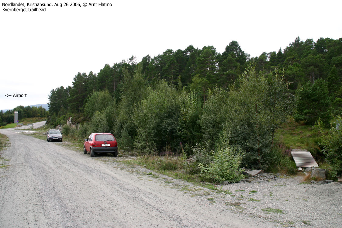
From Kristiansund, drive towards the airport. Just before the departure/arrival lanes, turn left onto a gravel road (per Aug 2006), drive 100m and locate the forest path (signed) on your left-hand side. You can find parking here.
The route
Follow the very visible path all the way to Kvernberget's west ridge, where you join another trail. Turn left and walk the remaining 300-400m up to the top.
I did NOT drive from Ålesund to Kristiansund just to hike Kvernberget. The plan was to continue to Tustna and Stabblandet and hike "Tustnastabbene". I stopped by the airport to pick up my friend Petter, flying in from Bergen. As I arrived a bit early, I decided to walk up to Kvernberget for some pictures. After all, this was my first time in Kristiansund. I did pass the city on the Coastal Express back in '84, but I wasn't very sober, so that doesn't count.
I left the trailhead by the airport 10:49AM. I carried my dog "Troll" as I didn't know how long this would take. Petter would be arriving 12:08PM, and I had to shop groceries and fill up fuel as well. I did not rush, but walked "efficiently" and stood on the top 11:09AM. I took my pictures and chatted with some kids who wanted to pet Troll.
I let Troll walk back to the car, which we arrived 11:35PM. After shopping groceries and fueling up, I still had time to read the newspapers before Petter (on-time) came walking along with his hiking boots around his neck. That guy knows how to travel "light"!
Trip reports from Tustna and Stabblandet coming up...


Views from the top


No Javascript:


No Javascript:
 westcoastpeaks.com
Other Møre & Romsdal mountains
Other Norwegian mountains
westcoastpeaks.com
Other Møre & Romsdal mountains
Other Norwegian mountains

