
|


Levandehornet is a peculiar Norwegian mountain name. Without knowing the origin of the name, it is tempting to translate to "Living Peak". It would be reasonable to assume that the name refers to, for instance, snowdrift on top of the mountain. But this is speculation, of course.
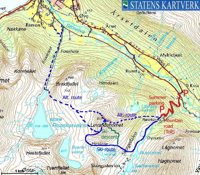
Moving over to facts, Levandehornet is one of the easier Ørsta skiing mountains, and thus - a popular mountain. Most skiers choose to start off in Årsetdalen by Vartdal, and follow Skorgedalen upwards. The convenient route runs up the south ridge, and experienced skiers look forward to descend the southeast flank. As you enter Skorgedalen, the east ridge is also a viable, yet steeper, alternative. And some choose to start off by Fosshola, and follow the pipeline up to Risaskarvatnet, before ascending the south or northwest ridge.
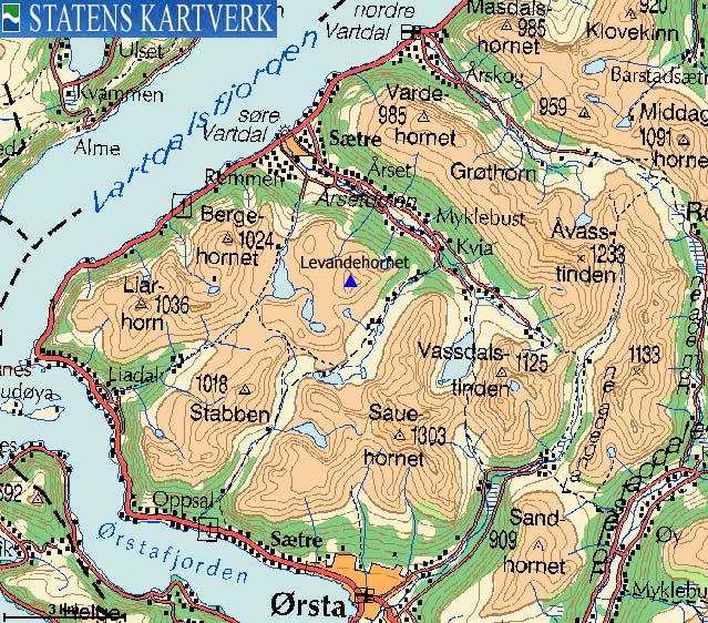
The primary views from Levandehornet are towards Åvasstinden, Kolåstinden, Vassdalstinden, Saudehornet, Hyningane, and the Grøthornet - Bergehornet ridge.
On hard snow, access to the Levandehornet ridges may require ice-axe and crampons.


Levandehornet (Norge 1:50,000: 917m, Økonomisk Kartverk: 917m, UTM 32 V 350363 6907547) has a primary factor of 287m, towards the higher parent mountain Hyningane (1018m). The saddle (approx. UTM 32 V 349723 6906467) is found by lakes Svartevatna. Ref. Norge 1:50,000 (20m contours), the saddle height is in the range 620-640m, interpolated to 630m.
Personal GPS measurement during a 15-minute period on top of the cairn (1,5m high, and error margins must be taken into consideration) read 917m.
Google's interactive map. You can zoom, pan and click on the markers.
Notes: Class ratings are in reference to YDS. Click here for more information.
The trails described below are not necessarily the *easiest* trails to this mountain.
|
Årsetdalen - Levandehornet (winter, on skis)
|
|
Access
(all distances are approx. distances)
From Ålesund, follow highway E39 towards Bergen/Volda to the ferry at Solavågen. Take the ferry over to Festøya. Turn right in the direction of Volda and follow the road 15,2Km to Vartdal. Turn left by the "Årsetdalen" sign, and follow the paved road to its end (on the south side of the river).
In summer, you can drive up a forest road (toll - NOK 20,-) on your right, and drive up to approx. 340m at the Skorgedalen entrance.


The route
Follow the forest road upwards. At approx. 340m elevation, the terrain levels out and you proceed to Lake Grasvatnet on gentle terrain. Turn west and pass north of Lake Heidavatnet, and proceed up to the Tverrfjellet - Levandehornet pass. Turn northeast and aim for Levandehornet's south ridge, and follow the ridge up to the summit cairn. Watch out for cornices on the north side of the summit.
Descend your ascent route, or descend the southeast flank, after considering any avalanche danger.


 westcoastpeaks.com
Other Møre & Romsdal mountains
Other Norwegian mountains
westcoastpeaks.com
Other Møre & Romsdal mountains
Other Norwegian mountains

