
Norwegian Mountains, Møre og RomsdalMelen, 807m (Fiksdalshornet)
|
| Fylke/Kommune : | Møre og Romsdal/Vestnes |
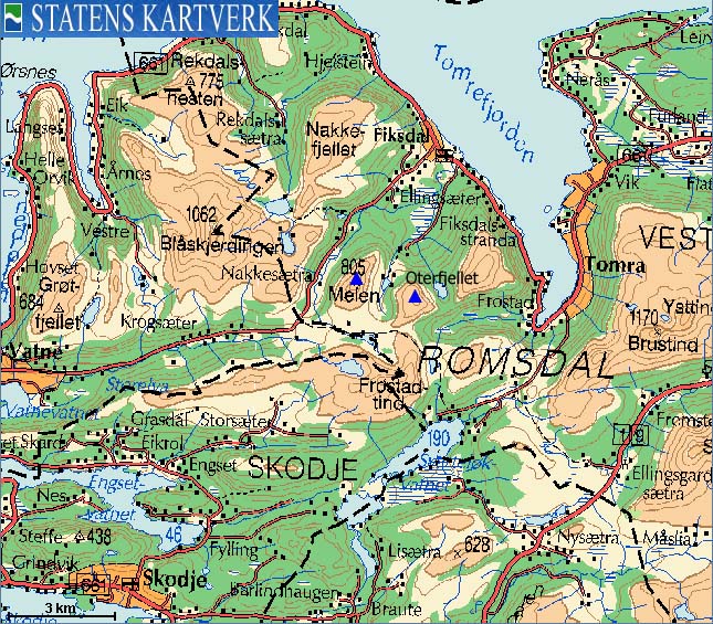
| Maps : | 1220-II Vestnes (Statens Kartverk, Norge 1:50 000) |
| Primary factor : | Melen: 499m |
| Primary factor : | Oterfjellet: 235m |
| Hiked : | Several times Mar 2006 - Dec 2007 |
| See also : | Frostadtinden |
| See also : | Storhaugen |
| See also : | Blåskjerdingen |
| See also : | Nakkefjellet |
| See also : | Other Vestnes mountains |

Melen seen from the north
(Click for larger image)
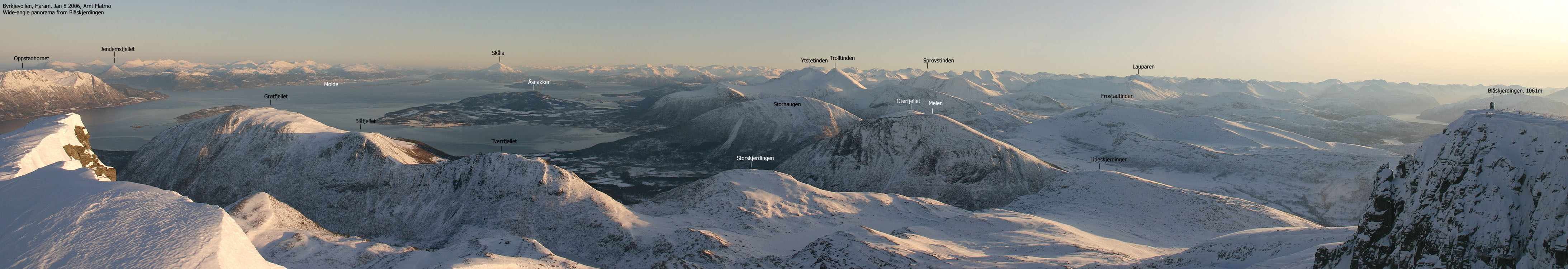
Melen, Oterfjellet and Frostadtinden are close neighbours and enclose Lake Mellivatnet. Frostadtinden is described on this page, but you can use the Melen/Oterfjellet trailhead (Reset) for ascending Frostadtinden on its northeast ridge. This trailhead is very popular among skiers on sunny winter days. If you want to obtain convenient parking, attend early.
Through their north ridges, Melen and Oterfjellet fall down towards Tomrefjorden, and define a dramatic and spectacular landscape. Both mountains are easy to ascend on the easiest routes, but their proximity to the sea might make for poor skiing conditions.
Melen is the more distinct mountain of the two, or three when you include Frostadtinden. Melen rises gently from Lake Vellivatnet and is easily identifiable from long distance. The mountain looks very much different when seen from Fiksdal (north), and certainly "deserves" the local name Fiksdalshornet. In many ways, Melen/Fiksdalshornet has similar characteristics as Eggjenibba between Skei and Byrkjelo.


If you're into scrambling and airy places then Melen's north ridge is a treat. A good round trip would be to hike up the south flank from Reset, traverse the north ridge and follow the road back up Nakkedalen. Crossing the river can be an issue, all dependant on the amount of water in the river.
The Melen traverse is described further down on this page, but in sum, this traverse demands head for heights and some (easy) scrambling experience. On slippery ground, this traverse is dangerous even on the easier parts.


Melen (M711: 805m, Økonomisk Kartverk: 807m, UTM 32 V 387642 6941079) has a primary factor of 499m towards the higher parent mountain Blåskjerdingen (1069m). The defining saddle (approx. UTM 32 V 385930 6939884) is found at Reset. Ref. Økonomisk Kartverk (5m contours), the saddle is within the range 305m-310m, interpolated to 308m.
Melen is 805m on the 1:50,000 map, but 807,0m on Økonomisk Kartverk. As Frostadtinden is 3cm lower (!!) on Økonomisk Kartverk, Melen will be the parent mountain of the two.
Oterfjellet (M711: 726m, Økonomisk Kartverk: 728m, UTM 32 V 389349 6940626) has a primary factor of 235m towards the higher parent mountain Frostadtinden (807m). The defining saddle (approx. UTM 32 V 388759 6939764) is found in Vatneskardet, between the two tops. Ref. Økonomisk Kartverk (5m contours), the saddle is within the range 490m-495m, interpolated to 493m. There is also a fixed point - 492,7m which confirms an optimal interpolation.

Google's interactive map. You can zoom, pan and click on the markers.
|
|
|
Notes: Class ratings are in reference to YDS. Click here for more information.
The trails described below are not necessarily the *easiest* trails to this mountain.
|
Route 1: Reset - Oterfjellet - Melen (winter)
|
|
Access
(all distances are approx. distances)
From Ålesund, follow highway E136->E39 towards Åndalsnes. From the E136/E39/Olsvika roundabout near Breivka, follow E39 approx. 13,3Km. Turn left onto highway RV661 (Skodje/Brattvåg/Vatne). After 1,5Km, pay toll at an unmanned toll booth (coins + credit cards + AutoPass). Approx. 9,7Km after you left E39, you reach the RV659 (Brattvåg)/661(Vatne) junction. Turn right and drive the remaining 11Km up Vatnedalen valley to the Reset trailhead. You pass the place Vatne along the way.
The route
From Reset, follow the "Vatneskardet" trailsign and head up to the valley that is defined by Melen, Oterfjellet and Frostadtinden. Stay north of the lake and choose your order of things. None of the ascents (including Frostadtinden) are difficult and should be fairly obvious.
Oterfjellet has a plateau on top with several small cairns. If you arrive in fog, seek to the northeast to find the cairn holding the visitor's register. Melen's visitor's register is not found at the summit point, but by a cairn a little further to the north (towards the north ridge). Frostadtinden also has a visitor's register at point 807m, which is the highest and the first you arrive if you ascend Frostadtinden from this side. You have a good opportunity to do a "grand slam" once you are between these three mountains.
See pictures from this route here.
|
Route 2: Reset - Melen north ridge traverse (summer)
|
|
Access
Same access as route 1 above.
The route
From Reset, do NOT follow the "Vatneskardet" trail. Instead, follow an unmarked path a few meters to the north. This path runs towards - and up the west side of Melen's north ridge. Crossing the river from Lake Mellivatnet can be awkward when the river is big. Seek for a place to cross.
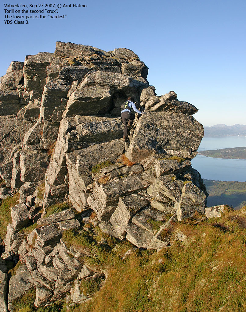
Once on Melen, continue across the ridge until you get to a 2-2,5m drop on the ridge (YDS class 4). This is a very exposed point, and some will feel the need for a rope here. It is probably easier to downclimb this section face out, but take of the backpack first! Be aware of loose rock at the bottom, put in place by humans. To get back up this point, climb face in, further to the right from where you lowered yourself.
Along the ridge, further careful scrambling is needed until you reach a col that cuts the ridge in two. Climbing down to - and up from the col is fairly easy, but the climb up is exposed. This is perhaps only a class 3 climb, but because of limited space, it might be class 4.
The rest of the ridge is trivial in comparison. Keep your cool across some narrow sections and do NOT stumble on grass turfs upon descent. You may lose the ridge path before you get down to the forest. Find a good route down to the forest, turn westbound and head towards the main road. Crossing the river from Lake Mellivatnet can be difficult when the river is large. Look for a good place to cross. Follow the main road 3Km back to Reset.
See pictures from this route here and here.
 westcoastpeaks.com
Other Møre & Romsdal mountains
Other Norwegian mountains
westcoastpeaks.com
Other Møre & Romsdal mountains
Other Norwegian mountains


