
For Information, maps, trailhead and route descriptions, click HERE.
I was to attend a confirmation in Velfjord 13:00PM, and as I woke up quite early, I figured it was time for some morning exercise. I decided to visit Mosaksla. I had no idea where the public route went, and skipped looking it up on Kjiver's regional "bible". I wanted to feel the exploring sensation, and then you have to start from scratch. I figured I should try the north ridge. It looked like a fun route.
On my way to Mosaksla, I dwelled on the - fairly dramatic - episode the evening before. I left Ålesund early morning, May 12, and came to Vennesund with the ferry in the afternoon. After a kilometer or so, I had two cars behind me, and a hilltop ahead. Just above the hilltop, I saw two moose just meters ahead of me. I literally stood on the brake, while thinking (and I'm not kidding) I think I can pass under the moose standing in my lane.
Because they were HUGE, and what the hell were they doing crossing the road only a minute from the Vennesund ferry? There's no forest here. Standing on the brake caused the tires to squeek, and the moose in my lane paniced, and jumped into the other lane just as I passed it's butt. By instinct, fortunately, I then hit the gas pedal to avoid having the two other cars up MY butt. The situation ended good for all parties. It was good to know that the reflexes were still intact after having driven 600Km non-stop.
Mosaksla would hopefully offer less drama. I drove well past the north ridge, turned around and began planning my route. The ridge west of Storfjelldalen became my choice. The next question was how to get on it. I decided to park my car down by the road and try my luck. 08:07AM, I was on my way, with a growing "exploring" sensation.
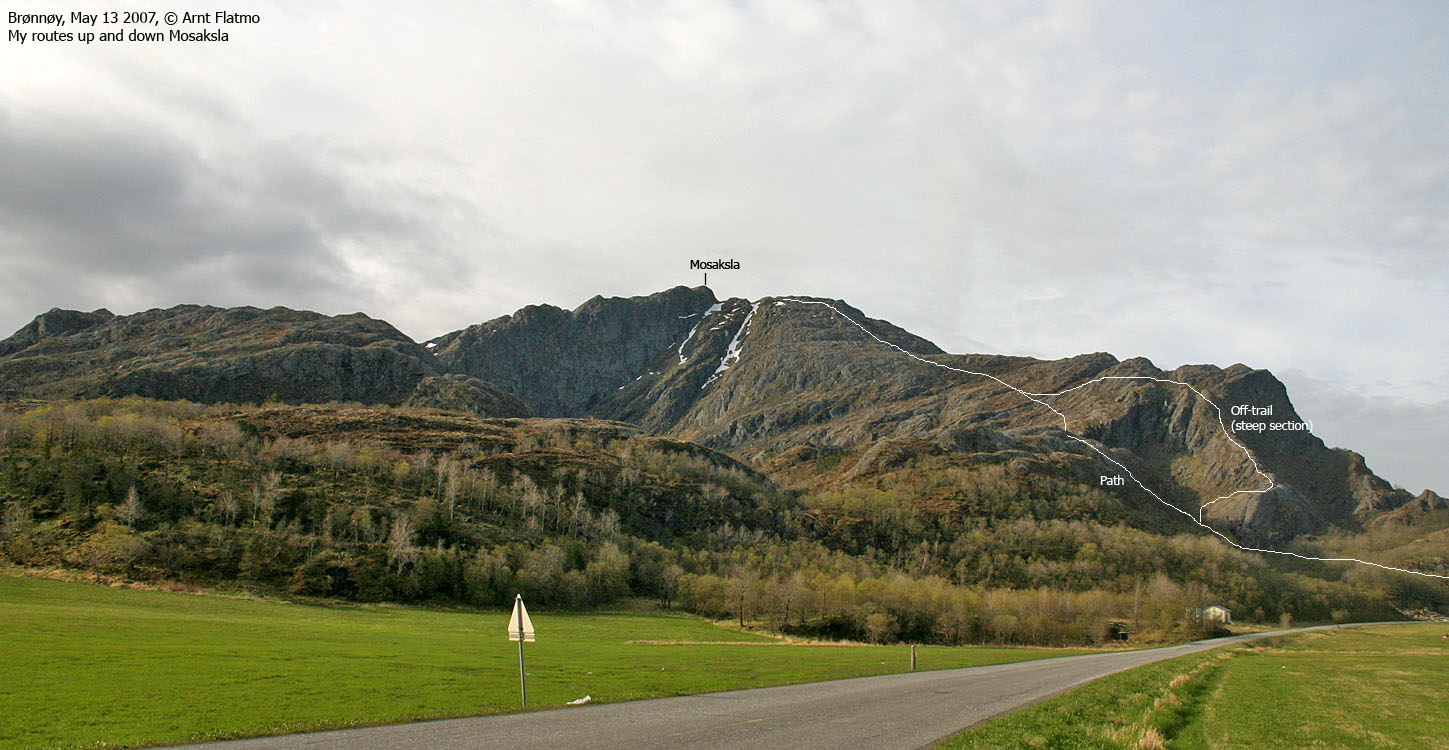
This sensation suffered from a sudden death after 5 minutes, when I stumbled onto the public trail. Oh well. But on my way up the mountain, I noticed another ridge that looked very cool. I wasn't confident that I would be able to descend it, but it would be fun trying. And now that I was on the public trail, I had time for a detour. In worst case.
I reached the top 08:50AM, took some pictures before I headed back down. Upon descent, I stayed west of the trail. A much better route, I thought. The grass was soft, opposed to the rocky trail further right. At 300m elevation, I joined my ascent route, but left it soon, aiming for this other ridge.
I had to cross a few smaller ridges in order to get to the correct one. The terrain got steeper and steeper, and I didn't expect to be able to descend this way. But the terrain wasn't all bad after all, and I found a convenient crack/gully that took me down to the lower section of this ridge.
I noticed another hiker on his way up, and I yelled "morning!" to him. He obviously wondered what I was doing on the other side of the basin, and I decided to be informative. "Nice route", I shouted, and pointed up the ridge. "No, too steep", he responded, thinking I was heading upwards. "I came down here", I replied. After a few seconds of silence, he shouted "Who are you?". I yelled my name back to him and waved goodbye. The "exploring sensation" had been satisfied, and it had been a good start of the day. I reached the official trailhead 09:36AM, and noticed that I had parked only 120m further down the road.
Now I had to focus on the upcoming confirmation, but in the back of my mind, I started wondering if there would be time for an evening hike. There was, and late in the evening, I visited Tilremshatten.
(Help text (ALT) is available when your cursor is above the thumbnails. Make sure you've got the ALT switch turned on in your browser)
To Mosaksla


Wide-angle view from Mosaksla

50mm views from Mosaksla


Other pics from Mosaksla


Descent


No Javascript:
1 2 3 4 5 6 7 8 9 10 11 12 13 14 15 16 17 18 19
 westcoastpeaks.com
Other Nordland mountains
Other Norwegian mountains
westcoastpeaks.com
Other Nordland mountains
Other Norwegian mountains