
|


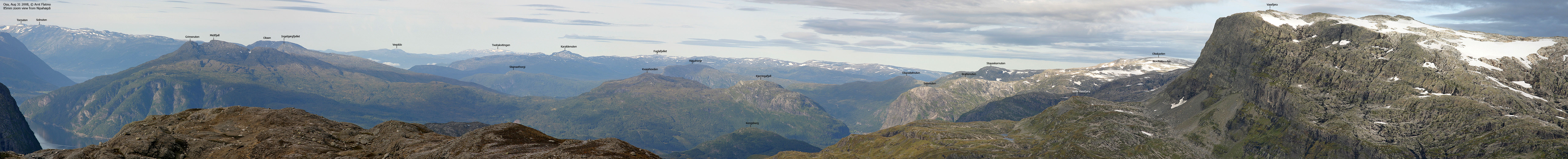
Oksen (The Bull) is one of the true landmarks along Hardangerfjorden. The mountain rises up from the Granvinsfjorden, Utnefjorden, Eidfjorden and Sørfjorden "junction", all local fjord arms in Hardangerfjorden.
Oksen is the southernmost/westernmost top on the peninsula named after the mountain - Oksenhalvøya. Oksen connects to Ingebjørgfjellet, which in turn connects to Midtfjellet (1255m) - the highest top on the peninsula as defined by fjords and the road between Granvin and Ulvik.


The 1996 edition of the Norge 1:50,000 map shows that the Granvin/Ullensvang kommune border runs across Oksen summit. Per 2007, Norgesglasset (interactive map on the internet) and the Garmin GPS map shows that the kommune border runs 400m north of Oksen high point. Westcoastpeaks.com assumes that this is a map error, and that Oksen belongs to both Granvin and Ullensvang.
Ingebjørgfjellet high point is located on a tri-kommune border between Ullensvang, Granvin and Ulvik.
A number of routes lead to Oksen. The mountain can almost be ascended from any side, but this web-page will only describe access from the north. The route runs up Verkadalen and takes you to Lake Oksatjørni, giving you a good chance of visiting both Oksen and Ingebjørgfjellet on the same hike.
Oksen (Norge 1:50,000: 1241m, Økonomisk Kartverk: Highest contour is 1240m, UTM 32 V 372581 6704864) has a primary factor of 573m, towards the higher parent Midtfjell (1255m). The saddle (approx. UTM 32 V 379202 6708712) is found N of Lake Dalsettjørni, between Midtfjell and Ingebjørgfjellet. The saddle may actually be just S of the lake also, resulting in the same primary factor. It is difficult to fully comprehend the saddle based on the maps. Ref. Økonomisk Kartverk (5m contours), the saddle is within the range 665-670m, interpolated to 668m.
Ingebjørgfjellet (Norge 1:50,000: 1210m, Økonomisk Kartverk: Highest contour is 1210,44m, UTM 32 V 376456 6707600) has a primary factor of 312m, towards the higher parent Oksen (1241m). The saddle (approx. UTM 32 V 374227 6705818 is found E of Lake Oksatjørni, between Oksen and Ingebjørgfjellet. Ref. Økonomisk Kartverk (5m contours), the saddle is within the range 895-900m, interpolated to 898m.
Google's interactive map. You can zoom, pan and click on the markers.
Notes: Class ratings are in reference to YDS. Click here for more information.
The trails described below are not necessarily the *easiest* trails to this mountain.
|
Oksen & Ingebjørgfjellet via Verkadalen (summer)
|
|


Access
From the centre of Granvin, follow signs towards Røynastrand. You will go through a 30Km zone and then drive on the gravel road until you see the Oksen trailhead sign on your left-hand side, roughly 3,2Km from the RV7 junction in Granvin. The trailhead can fit two cars on the right-hand side.


The route
This information was valid for the summer of 2001
Study the trail information sign at the trailhead. The trail starts off very visible, along the fence. After a couple of minutes, and due to high grass, you may to look hard to see the trail. Once past this section, the rest of the trail should be obvious. This is not a winter trail. The red sticks that occasionaly occur, doesn't help you if the snow covers the trail.
The trail runs steep up to 500m, in the southeast direction. At 500m elevation, the trail descends about 100m before you reach Verkadalslii valley. At one point on the descent, be careful where water is running from a crossing stream. It may be slippery, and a fall will not be a positive experience. This section only lasts for a few meters.
Having completed the descent into the neighbouring valley, you will notice a shelter (a big rock) for sheep. A saltstone may be seen there. From the shelter, the trail joins the river and runs upwards through the forest until it reaches the mountain foothills.
When you rise above the tree-line, you are in a valley with Verkadalsnuten on your left, and the northwest foothills of Oksen on your right. The trail is still visible, but in addition, the trail is marked with small cairns. The trail leads you up through a pass, and at approx. 900m, you reach Larsbu hut and lake Oksatjørni.
Cross the lake once you reach it. Follow the cairns up to Oksen.
The Ingebjørgfjellet trail:
From Larsbu, just head on upwards. You may find yourself following vague paths here and there, but just maintain your course towards Redfjellet. On top of Redfjellet, continue across Småskorenuten (1140m) before you begin the final ascent to Ingebjørgfjellet (1210m). Upon returning, follow the same way back to Larsbu.


No Javascript:
1 2 3 4 5 6 7 8 9 10 11 12 13 14 15 16 17 18 19 20 21 22 23 24 25 26
 westcoastpeaks.com
Other Hordaland mountains
Other Norwegian mountains
westcoastpeaks.com
Other Hordaland mountains
Other Norwegian mountains

