Norwegian Mountains, Møre og Romsdal
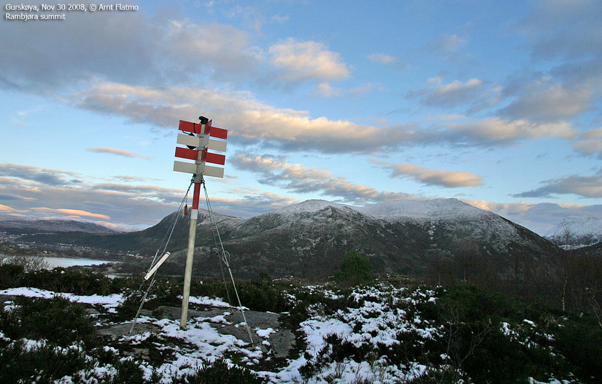
Rambjøra, 132m
| Fylke/Kommune : |
Møre og Romsdal/Herøy |
| Maps : |
1119-I Ålesund (Statens Kartverk, Norge 1:50 000)
|
| Primary factor : |
109m |
| Hiked : |
Nov 2008 |
| See also : |
|
| See also : |
Other Herøy
mountains |

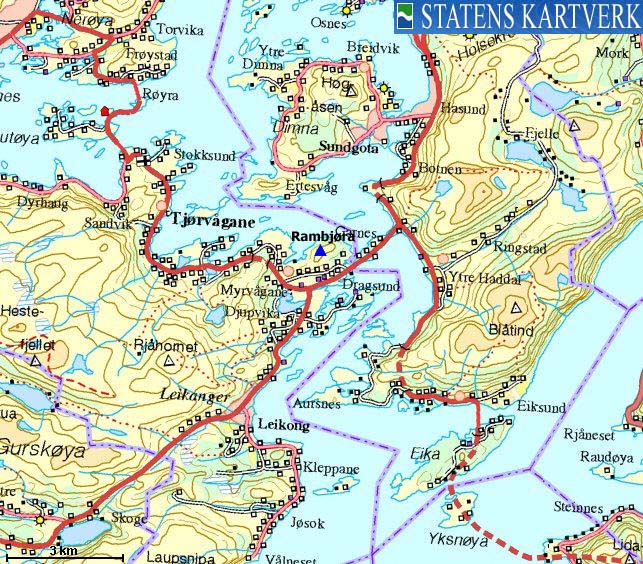
The route to Rambjøra

(Click for larger image)
Introduction
Rambjøra is one of lowest coastal tops on Gurskøya, located
near Dragsundet - the 50m wide sound between Hareidlandlandet and Gurskøya
islands. A vague path reveals that the top isn't attracting the crowds, but it
is a nice viewpoint towards the higher tops on Hareidlandet and Gurskøya
and the Vanylven tops facing
Rovdefjorden.
Primary factor:
Rambjøra (Norge 1:50,000: 132m, Økonomisk
Kartverk (ØK): 132,36m, UTM 32 V 334799 6910012)
has a primary factor of 109m
towards the higher parent mountain Huldrehornet (271m).
The defining saddle (approx. UTM 32 V 333764 6909438) is found along the highway
654 at Myrvågane. Ref. Økonomisk Kartverk
map
(5m contours), the saddle is within the range
20-25m, interpolated to 23m.
GPS measurement on top of the trig. point (2m high) read
132m, averaged over a
5-minute period (error margin +/- 1,4m).
Google map
Google's interactive map. You can zoom, pan and click on the markers.
Trail descriptions
|
Route 1: Myrvågane - Rambjøra (all seasons)
| Difficulty : |
YDS
Class 1 |
| Exposure : |
No |
| Distance : |
Approx. 1,1km to the top |
| Time : |
Approx. 25 mins to
the top |
| Starting Elev.: |
Approx. 30m |
| Vertical Gain : |
Approx. 100m |
|
|
Access
(all distances are approx. distances)
The nearest larger city is Ålesund.
From Ålesund, follow highway E39 towards Bergen, and then RV61 towards Hareid. Take the
Sulesund - Hareid ferry. From the roundabout in Hareid, follow RV61/RV653 and
pass Ulsteinvik (11,1km), and turn right towards Måløy/Fosnavåg after
16,8km.
Reset your odometer. Continue on highway 654km. Cross the
bridge across Dragsundet, ignore the Måløy junction (2,9km) and turn right
after 3,5km (signposted "Aldersheim"). You have a 3-way fork ahead of you. Take
the middle road and drive 200m. Turn left when you see the "Eldreboliger"
sign. The path begins
100m up the road - just before the "horseshoe" (road loop). Find parking where
appropriate.
The route
If you don't see the path right away, just follow the
ridge, and you'll be on the path quite soon. Follow the path all the way to the
top, which is marked by a
trigonometric point.
Other pictures
- Rambjøra, Lunch hike, Mar 21 2024
- Rambjøra, Trail maint., Mar 14 2024
- Rambjøra, Mar 7 2024
- Rambjøra, Mar 3 2024
- Rambjøra, Feb 29 2024
- Rambjøra, Feb 20 2024
- Huldrehornet & Rambjøra, Feb 12 2024
- Dragsund, Feb 11 2024
- Rambjøra, Feb 10 2024
- Rambjøra, Feb 9 2024
- Road pics & Rambjøra, Feb 8 2024
- Rambjøra, Feb 1 2024
- Rambjøra, breaking trail, Jan 19 2024
- Rambjøra, breaking trail, Jan 17 2024
- Rambjøra, breaking trail, Jan 15 2024
- Rambjøra, just after getting back home, Jan 1 2024
- Rambjøra, last hike back home in 2023, Dec 11 2023
- Rambjøra, w/Anne, Dec 4 2023
- Rambjøra, not well, Nov 27 2023
- Rambjøra, not well, Nov 24 2023
- Rambjøra, not well, Nov 22 2023
- Rambjøra, not well, Nov 20 2023
- Rambjøra, Trail maint., Nov 7 2023
- Rambjøra, Trail maint., Nov 7 2023
- Rambjøra, Trail maint., Nov 3 2023
- Rambjøra, Trail maint., Oct 23 2023
- Rambjøra, Trail maint., Oct 12 2023
- Rambjøra, Trail maint., Oct 9 2023
- Rambjøra, Trail maint., Oct 7 2023
- Rambjøra, Trail maint., Oct 6 2023
- Rambjøra, Trail maint., Sep 29 2023
- Rambjøra, Trail maint., Sep 28 2023
- Rambjøra, Trail maint., Sep 25 2023
- Rambjøra, Trail maint., Sep 19 2023
- Rambjøra, Trail maint., Jul 10 2023
- Rambjøra, Trail maint., Jun 2 2023
- Rambjøra, Trail maint., May 24 2023
- Rambjøra, Trail maint., May 10 2023
- Rambjøra, Tovågane, Mar 22 2023
- Dragsund, Mar 12 2023
- Dragsund, Mar 11 2023
- Rambjøra, Feb 20 2023
- Dragsund, Jan 30 2023
- Dragsund, Jan 19 2023
- Rambjøra, Jan 18 2023
- Dragsund, Jan 13 2023
- Dragsund, Jan 9 2023
- Rambjøra, Jan 8 2023
- Dragsund, Jan 4 2023
- Rambjøra, Jan 2 2023
- Rambjøra w/Anne & Karma, after Covid, Dec 11 2022
- Huldrehornet & Rambjøra, Nov 4 2022
- Rambjøra trail maint., Oct 10 2022
- Rambjøra trail maint., Oct 7 2022
- Dyrkyrkja, Rambjøra, Oct 6 2022
- Rambjøra, Sep 12 2022
- Rambjøra trail maint, Aug 15 2022
- Rambjøra trail maint, Jun 28 2022
- What did Karma come across?, May 18 2022
- Rambjøra trail maint, May 2 2022
- Rambjøra trail maint, Apr 25 2022
- Rambjøra trail maint, Apr 10 2022
- Rambjøra trail maint. w/Anne, Apr 4 2022
- Rambjøra w/Anne, Apr 2 2022
- Rambjøra, Feb 24 2022
- Rambjøra, Feb 19 2022
- Rambjøra, Feb 18 2022
- Rambjøra, Feb 4 2022
- Rambjøra, Jan 31 2022
- Rambjøra & trail maintenance, Jan 28 2022
- Rambjøra & trail maintenance, Jan 28 2022
- Rambjøra & trail maintenance, Jan 24 2022
- Rambjøra, Jan 5 2022
- Rambjøra trail maint, Jun 29 2021
- Trail maintenance, Jun 17 2021
- Rambjøra trail maint, Jun 12 2021
- Rambjøra, Mar 4 2021
- Rambjøra, Jan 23 2021
- Rambjøra, Jan 10 2021
- Rambjøra & Dragsund, Dec 2 2020
- Rambjøra & Covid-19 test, Aug 13 2020
- Rambjøra - trail work, July 17 2020
- Rambjøra - trail work, July 6 2020
- Rambjøra - trail work, July 4 2020
- Rambjøra - trail work, June 30 2020
- Rambjøra - trail work, June 26 2020
- Rambjøra - trail work, June 23 2020
- Rambjøra, June 6 2020
- Rambjøra - off-trail, May 14 2020
- Rambjøra - trail work, Mar 29 2020
- Rambjøra & Jonseholmen, Mar 28 2020
- Rambjøra round trip, Feb 21 2020
- Rambjøra with Anne, Nov 6 2019
- Rambjøra round trip, Sep 22 2019
- Rambjøra round trip on skis, Jan 17 2019
- Rambjøra, Oct 22 2018
- Rambjøra, Apr 5 2018
- Rambjøra seen from other mountains
 westcoastpeaks.com
Other Møre & Romsdal mountains
Other Norwegian mountains westcoastpeaks.com
Other Møre & Romsdal mountains
Other Norwegian mountains
|


