
Norwegian Mountains, Møre og RomsdalRamstadvarden, 965m (ca.)
|
| Fylke/Kommune : | Møre og Romsdal/Sykkylven & Stordal |
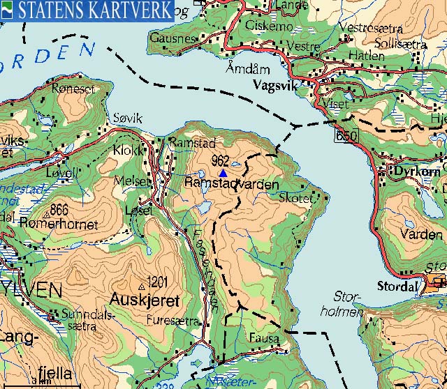
| Maps : | 1219-I Stranda (Statens Kartverk, Norge 1:50 000) |
| Primary factor : | Ramstadvarden: 627m |
| Primary factor : | Sjurlihornet: 114m |
| Primary factor : | Storheirøra: 83m |
| Primary factor : | Fausateighornet: 64m |
| Hiked : | Aug 2007 - Oct 2007 |
| See also : | Varden |
| See also : | Sandvikshornet |
| See also : | Rømerhornet |
| See also : | Auskjeret |
| See also : | Roaldshornet |
| See also : | Skurdahornet |
| See also : | Other Sykkylven and Stordal mountains |
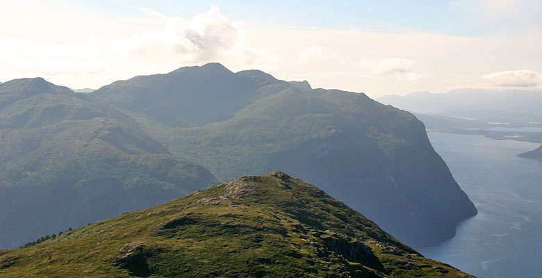
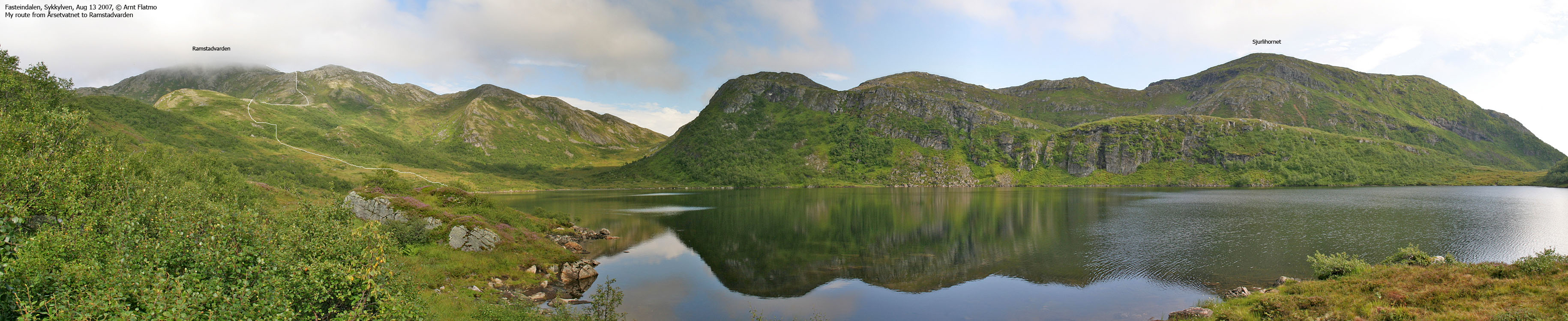
Ramstadvarden seen from Varden
Ramstadvarden (the name comes from the farm Ramstad below the mountain) is the highest point in a mountain region between Storfjorden and the Fasteindalen/Ramstaddalen valleys. On this ridge, you will find a number of tops, including Sjurlihornet (829m), Storheirøra (805m) and Fausateighornet (794m). The Sykkylven / Stordal kommune (municipality) border runs across these tops, but Ramstadvarden belongs fully to Sykkylven.
The normal route to Ramstadvarden runs from Årsetsætra in Fasteindalen. A path runs up to, and along Lake Årsetvatnet and ascends up through the Brekka pass (715m) before it descends to Skotet by Storfjorden. Somewhere along Lake Årsetvatnet, you head off-trail/on vague path up to a ridge which leads up to Ramstadvarden. The terrain is in general quite easy. The view from the Ramstadvarden is excellent. From the summit cairn, head eastbound to get Storfjorden in view.
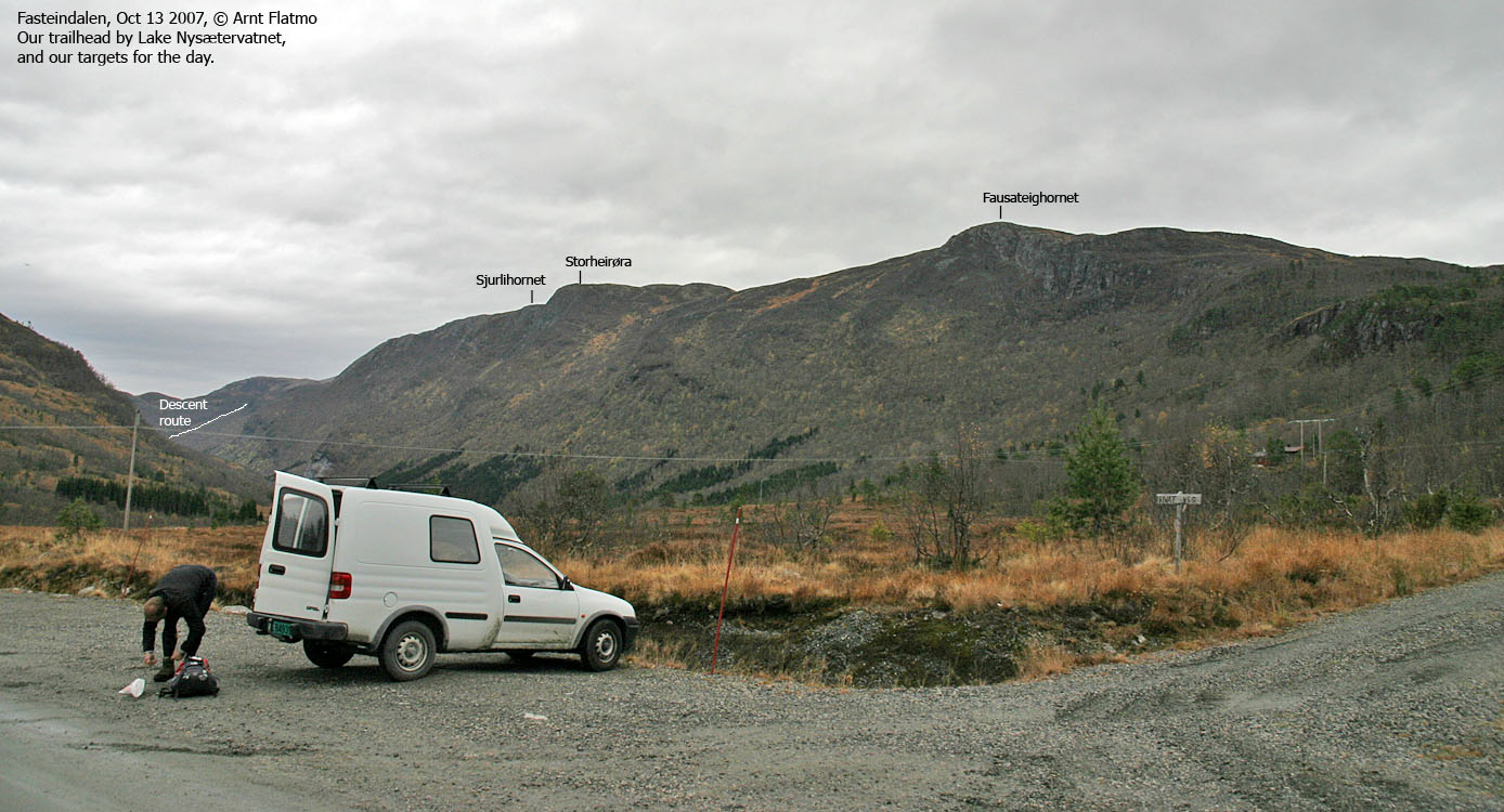
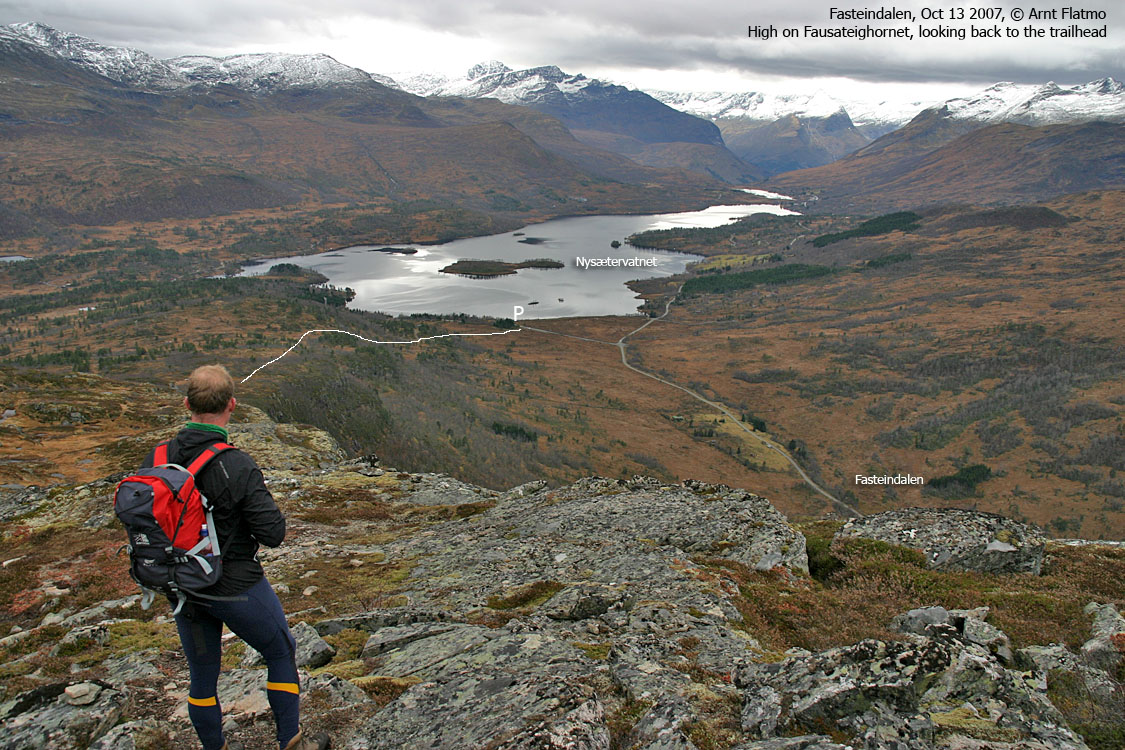
The normal route to Fausateighornet runs from Lake Nysætervatnet, on a nice path. A route that continues across Storheirøra and Sjurlihornet is also described on this page. This route descends (steep) to Årsetvatnet and descends the normal route to Ramstadvarden. This mountain region is excellent for skiing.
The shortest route to Sjurlihornet and Storheirøra seems to run from Leitet. There is a path in a distinct gully just north of Storheirøra. Hopefully, one day this route will be presented on this page.
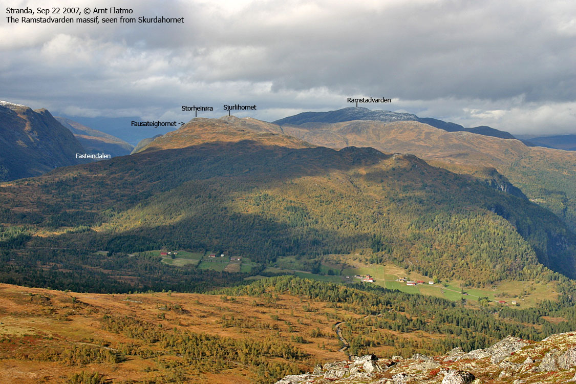
Ramstadvarden region
Click for larger image.
Ramstadvarden (Norge 1:50,000: -, Økonomisk Kartverk: Highest contour is 965m, UTM 32 V 388173 6922696) has a primary factor of 627m, towards the higher parent mountain Auskjeret (1203m). The saddle (approx. UTM 32 V 387209 6915970) is found at the north end of Lake Nysætervatnet. Ref. Økonomisk Kartverk (5m contours), the saddle height is within the range 335-340m, interpolated to 338m.
Personal GPS measurement averaged (over 10 minutes) Ramstadvarden's height to 967m, with an error margin of 1,8m. Based on the terrain, it is reasonable that Ramstadvarden's height is approx. the same as the highest ØK contour (965m). The 962m (961,60m) trigonometric point found on the 1:50,000 map is not the high point. In fact, no cairn was found where the map trig. point is. Another cairn was found 107m west of the high point. Another point, almost equally high, marked by a few rocks was found 48m southeast of the high point. The high point is marked by a tall cairn.


Sjurlihornet (Norge 1:50,000: 829m, Økonomisk Kartverk: 829m, UTM 32 V 387674 6920029) has a primary factor of 114m, towards the higher parent mountain Ramstadvarden. The saddle (approx. 32 V 388602 6921592) is found at Brekka, between Sjurlihornet and Ramstadvarden. Ref. Økonomisk Kartverk (5m contours), the saddle height is defined as a fixed point - 714,5 ~ 715m.
Storheirøra (Norge 1:50,000: 805m, Økonomisk Kartverk: 805m, UTM 32 V 387859 6919063) has a primary factor of 83m, towards the higher parent mountain Sjurlihornet. The saddle (approx. 32 V 387756 6919653) is found between these two tops. Ref. Norge 1:50,000 (20m contours), the saddle height is within the range 720-740m. The normal interpolation would yield 730m, however, based on GPS readings and how the terrain appeared, the saddle height has been set to 722m.
Fausateighornet (Norge 1:50,000: 794m, Økonomisk Kartverk: 794,33m, 32 V 388419 6917933) has a primary factor of 64m, towards the higher parent mountain Storheirøra. The saddle (approx. 32 V 388205 6918384) is found between these two tops. Ref. Norge 1:50,000 (20m contours), the saddle height is within the range 720-740m, interpolated to 730m (and this height matches the GPS readings as well).
Google's interactive map. You can zoom, pan and click on the markers.
|
|

Norge i 3D Click on image (Java required) |
Notes: Class ratings are in reference to YDS. Click here for more information.
The trails described below are not necessarily the *easiest* trails to this mountain.
|
Route 1: Årsetsætra - Ramstadvarden (summer/autumn)
|
|
Access
(all distances are approx. distances)
From Ålesund, follow highway E39 towards Bergen, and then highway RV60 (Stranda) to the Magerholm - Ørsneset ferry (towards Sykkylven). This ferry runs quite often; every 20 minutes in the busy hours of the day. From Ørsneset, follow RV60 (Stranda) approx. 2,6Km and turn left towards "Ramstaddal". Follow this road 12,2Km, to a road junction. Turn right (Fjellseter) and drive 2,6Km. You are now in another junction. Turn right (Fjellseter). Drive 1,1Km and park when you see the "Skotet" trailsign.
The route
A path takes you more or less straight up to Lake Årsetvatnet. After rain, high grass will make your trousers wet in the forest. At the lake, cross the dam (obvious) and follow a path along the lake marked by red paint.
Up to your left, you will see a lower ridge connecting to the main ridge and Ramstadvarden. Pass the drain from Lake Svartevatnet, cross a meadow and head up the ridge. This section is off-trail. There is supposed to be a faint path leading up to this ridge, but there is no point searching for it.
Once on the ridge, the rest of the route is obvious. Head towards the main ridge and follow the terrain to the left (northeast) until you reach the top of Ramstadvarden. The summit is marked by a tall cairn. You will see another cairn approx. 100m further west.
The trails described below are not necessarily the *easiest* trails to this mountain.
|
Route 2: Nysætervatnet - Årsetsætra traverse across
Fausateighornet, Storheirøra and Sjurlihornet (summer/autumn)
|
|
Access
(all distances are approx. distances)
From Ålesund, follow highway E39 towards Bergen, and then highway RV60 (Stranda) to the Magerholm - Ørsneset ferry. This ferry runs quite often; every 20 minutes in the busy hours of the day. From Ørsneset, follow RV60 (Stranda) approx. 22,4Km and turn left towards "Fausa/Fjellsætra". Drive 6,2Km to the Fausa/Orreneset junction and turn right (Fausa). Drive 230m and find parking on the left-hand side of the road.
Note: This route assumes that you have transport from Årsetsætra back to Nysætervatnet. If not, you will have to add 4,8Km to the total distance.
Fausateighornet
Follow a gravel road 200m upwards, then follow a T-marked route (red paint) to your left. The path crosses under the powerline and leads you up Fausateighornet's southwest ridge. The path is easy to follow. The top of Fausateighornet is marked by two tall cairns.
Storheirøra
Proceed on a vague path northbound towards Storheirøra. Path or no path, the terrain is quite gentle. You'll pass a few rocks (put there by someone) before you reach the high point. The high point is not marked. 150m N/NW of Storheirøra, notice the gully that runs towards Leitet. This might be a possible shortcut to Fasteindalen. A path is at least seen in the upper part of the gully.
Sjurlihornet
Proceed northbound on a vague path which disappears as you begin ascending Sjurlihornet. On Sjurlihornet summit you will find a broken trigonometric point, but no cairn.
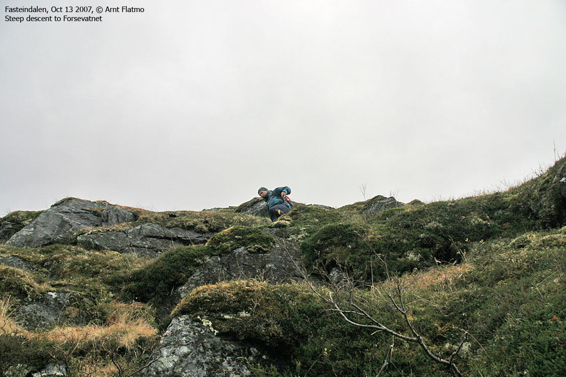
Descent
From Sjurlihornet, continue northbound. Pass one hump, then head up another (UTM 32 V 387728 6920717) to get a good overview of the steep drop towards Lake Forsevatnet. Descend to a ledge that does not allow for further progress. Turn left (west) and pass above a cliff section until you can descend on grass west of these cliffs. Then follow a ridge down a gully and then the gully down to the lake. This descent is steep, but easy (YDS class 2).
From Lake Forsevatnet, head west and curve around a ridge that is between you and Årsetvatnet. Then descend to Årsetvatnet and follow the western shore on a nice path. Just before you reach the dam, the path runs up to your left and comes back down to the dam. Follow this detour unless you like to scramble.

The descent route from Sjurlihornet
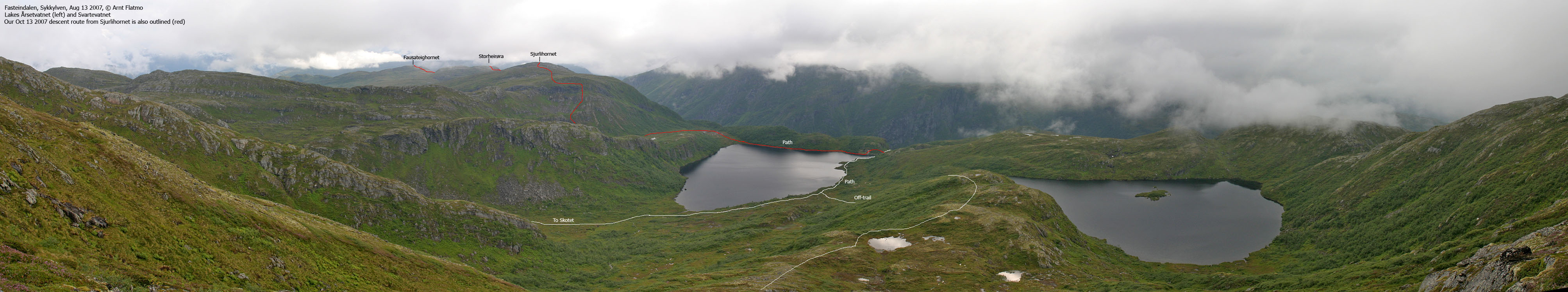
Click for larger image.
 westcoastpeaks.com
Other Møre & Romsdal mountains
Other Norwegian mountains
westcoastpeaks.com
Other Møre & Romsdal mountains
Other Norwegian mountains


