
Norwegian Mountains, Møre og Romsdal
|
| Fylke/Kommune : | Møre og Romsdal/Sande | ||||
| Maps : |
1119-III Vanylven (Statens Kartverk, Norge 1:50 000)
1119-III Fosnavåg (Statens Kartverk, Norge 1:50 000) |
||||
| Primary factor : |
Rinden: 369m Øyna: 51m Hornet: 232m Dollsteinen: 109m Vorakletten: 115m Svadfjellet: 94m Voren: 68m |
||||
| Hiked : | May 2007 (Rinden), Jan 2009 (Dollsteinen), Apr 2010 (Major round trip) | ||||
| See also : |
| ||||
| See also : | Other Sande mountains |

Sandsøya
(Click for larger image)
Sandsøya is a beautiful coastal island, located between Stadlandet and Gurskøya. You get there by ferry from Åram or Larsnes to the island Voksa. From Voksa, you drive across Marøyna and Trettholmane before you arrive on Sandsøya.
Rinden (369m) is the highest point on the island, and there are other tops that also are worth a visit. Dollsteinen is the most characteristic peak, while the Dollsteinhola cave is the #1 attraction on the island. A good recommendation is to take a weekend trip to Sandsøya, rent a cabin (rorbu), do 7-toppsturen on Saturday and explore Dollsteinen and Dollsteinhola on Sunday.
This is an annual hike, organized by Sandsøy Idrettslag. The hike runs across Vorakletten, Voren (Kulen), Rinden, Øyna (Signalen), Hellandsfjella (Svadfjellet), Grøntua and Hornet. The total distance is 16km, and the vertical gain is 1000 meters. Per 2009, the record was 1 hour, 42 minutes. This page will describe the paths to all the tops.

7-toppsturen on Sandsøya
(Click for larger image)
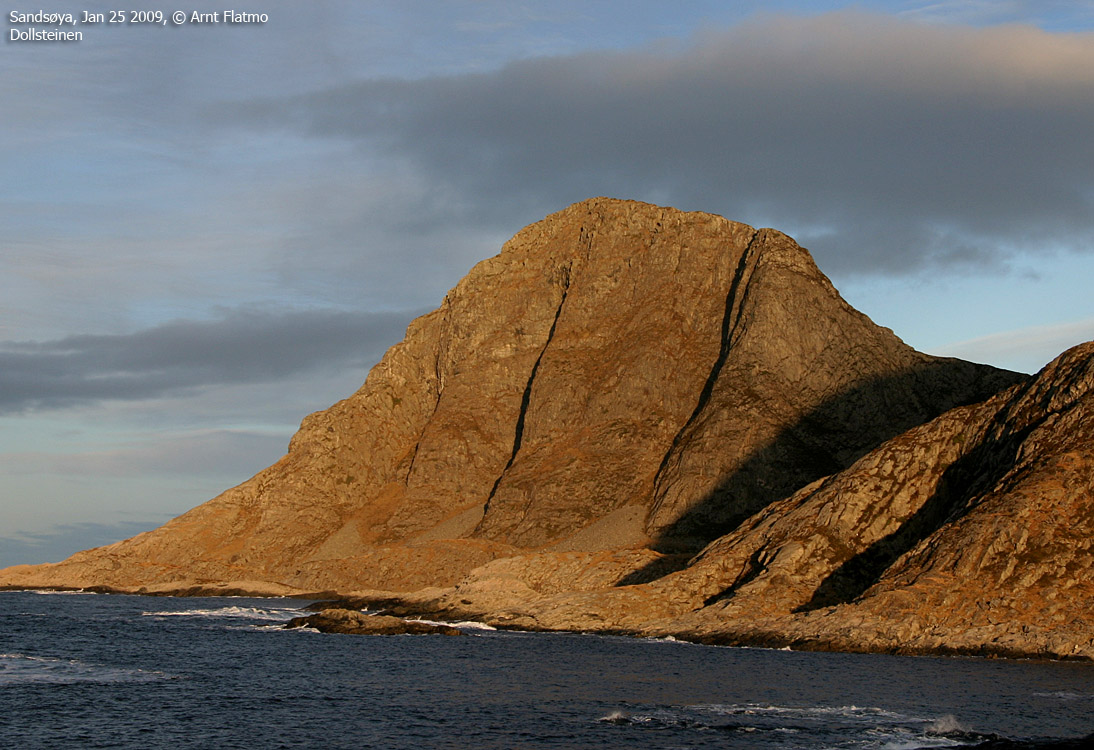
Dollsteinen (on some maps named Dallsteinen) is a very characteristic top on the northwest side of Sandsøya island. This mountain is also the home of Dollsteinhola, a 180m long cave which is best explored in the company of a guide, as the cave rooms and tunnels are a bit intricate. Myths and legends are associated to this cave. Search on the internet for detailed information.
The cave is extremely muddy and you need to dress accordingly. Claustrophobia is a disadvantage, and you shouldn't mind climbing up and down sections of 3-4 meters, while putting your trust in old and slippery ropes. If caves like this don't trigger your interest, you could settle for Storegjøtten and Veslegjøtten - two smaller and friendlier caves that you pass on the route from Skare.

Inside Dollsteinhola
(Click for larger image)
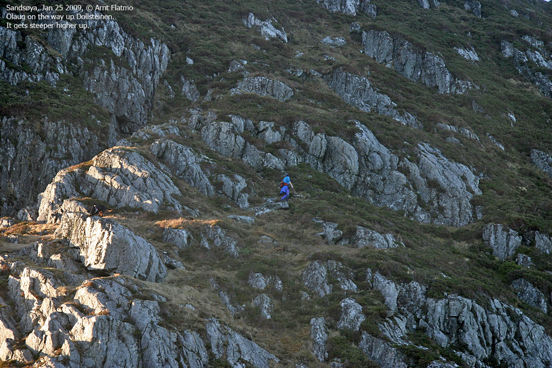
Dollsteinen can be reached either from Skare or Helland. The Helland trailhead offers the shortest route to Dollsteinen, but if you also want to visit Dollsteinhola, you might as well enjoy the nice route along the shore from Skare. Either way, you have to get up to the Dollsteinen - Øyna ridge and ascend Dollsteinen on its east ridge. The upper part of the route has a short and steep section. You don't need to use your hands, but if the ground is icy, exercise utmost caution or don't go up at all.

Dollsteinen
(Click for larger image)
Rinden (Norge 1:50,000: 369m, Økonomisk Kartverk: 369,01, 370,41, 371,50m, UTM 32 V 314585 6907196) has a primary factor of 369m, being the highest point on Sandsøya island.
GPS measurement read 370m (on the cairn - approx. 130cm), averaged over a 5-minute period (error margin +/- 4m)
Dollsteinen (Norge 1:50,000: 227m, Økonomisk Kartverk: Highest contour is 220m, UTM 32 V 313152 6908164) has a primary factor of 109m towards the higher parent Øyna (359m). The defining saddle (approx. UTM 32 V 313416 6908139) is found between between Dollsteinen and Øyna. Ref. Økonomisk Kartverk (5m contours), the saddle is within the range 115-120m, interpolated to 118m.
GPS measurement read 225m (on the ground), averaged over a 10-minute period (error margin +/- 2,7m).
Øyna/Signalen (Norge 1:50,000: 359m, Økonomisk Kartverk: Highest contour is 355m, UTM 32 V 314093 6907776) has a primary factor of 51m towards the higher parent Rinden. The defining saddle (approx. UTM 32 V 314437 6907572) is found near Vassmyrane. Ref. Økonomisk Kartverk (5m contours), the saddle is within the range 305-310m, interpolated to 308m.
GPS measurement read 363m (on a stick - approx. 150cm), averaged over a 5-minute period (error margin +/- 3m).
Hellandsfjella/Svadfjellet (Norge 1:50,000: 122m, Økonomisk Kartverk: 122,35m, UTM 32 V 314620 6908851) has a primary factor of 94m towards the higher parent Rinden. The defining saddle (approx. UTM 32 V 314722 6908336) is found along the road between Helland and Vågen. Ref. Økonomisk Kartverk (5m contours), the saddle is within the range 20-25m, interpolated to 28m.
GPS measurement read 124m (on a stick - approx. 150cm), averaged over a 5-minute period (error margin +/- 3m).
Hornet (Norge 1:50,000: 250m, Økonomisk Kartverk: 250,13m, UTM 32 V 316899 6908359) has a primary factor of 232m towards the higher parent Rinden. The defining saddle (approx. UTM 32 V 315683 6908575) is found at Våge. Ref. Økonomisk Kartverk (5m contours), the saddle is within the range 15-20m, interpolated to 18m.
GPS measurement read 249m (on a stick - approx. 150cm), averaged over a 5-minute period (error margin +/- 3m).
Vorakletten (Norge 1:50,000: 130m, Økonomisk Kartverk: 130,49m, UTM 32 V 317548 6906020) has a primary factor of 115m towards the higher parent Rinden. The defining saddle (approx. UTM 32 V 316533 6906309) is found between Voren and Bringsvor. Ref. Økonomisk Kartverk (5m contours), the saddle is defined as a fixed point - 15m.
GPS measurement read 133m (on a stick - approx. 150cm), averaged over a 5-minute period (error margin +/- 5m).
Voren/Kulen (Norge 1:50,000: 100m contour, Økonomisk Kartverk: 115m contour, Westcoastpeaks: 116m, UTM 32 V 317185 6906027) has a primary factor of 68m towards the higher parent Vorakletten. The defining saddle (approx. UTM 32 V 317346 6906044) is found in a small valley between the tops. Ref. Økonomisk Kartverk (5m contours), the saddle is within the range 45-50m, interpolated to 48m.
GPS measurement read 118m (on the ground), averaged over a 5-minute period (error margin +/- 3m).

Rinden on Sandsøya
(Click for larger image)
Google's interactive map. You can zoom, pan and click on the markers.
|
|
|
|
All tops
|
|
These route descriptions are valid per
April
2010
Access
(all distances are approx. distances)
To get to Sandsøya island, take the Larsnes - Åram - Kvamsøya - Sandsøya ferry to Voksa, and drive 4,2km to the Voksa/Sandshamn junction (N62.24334 E5.47321) on Sandsøya. This junction is the starting point for all route descriptions below.

The route to Rinden
(Click for larger image)
Alternative 1 (primary route - from the east):
From the Voksa/Sandshamn junction on Sandsøya, drive 280 meters in the direction of Sandshamn. At a fork, turn left and drive 200 meters up to a school, where you can park (N62.24504 E5.46780).
From the school, follow the road 300 meters to the west, then turn right onto a forest path when you see the Rinden signpost. Pass a barn and follow the marked path up the ridge. Rinden summit (N62.25045 E5.42937) is marked by a medium-sized cairn. If you want to visit Øyna/Signalen (N62.25539 E5.41930), continue across Rinden and follow the path for 1,1km - past Vassmyrane.
The starting point (the school) is approx. 10 meters, the vertical gain 360 meters, the total distance 2,5km and the estimated time is 1 hour. This is a YDS class 1 route; no difficulties.
Alternative 2 - from the west:
From the Voksa/Sandshamn junction on Sandsøya, drive 280 meters in the direction of Sandshamn. At a fork, turn left and drive 150 meters up to another fork (near the school - described above). Turn right and drive 2,5km along Vågen to Våge. Turn left and drive 2km to the end of the road. Park here (N62.26166 E5.41434).
Follow a path for 700 meters up to the Dollsteinen - Øyna saddle. Continue up the ridge up to Øyna, then follow the path past Vassmyrane and then up to Rinden.

Upper part of the route to Dollsteinen
(Click for larger image)
Alternative 1 (primary route):
This is the same starting point as for Øyna (see above).
From the Voksa/Sandshamn junction on Sandsøya, drive 280 meters in the direction of Sandshamn. At a fork, turn left and drive 150 meters up to another fork (near the school - described above). Turn right and drive 2,5km along Vågen to Våge. Turn left and drive 2km to the end of the road. Park here (N62.26166 E5.41434).
Follow a path for 700 meters up to the Dollsteinen - Øyna saddle, then turn right and follow the steep path up to Dollsteinen (N62.25841 E5.40081). The summit is not marked.
The starting point is approx. 10 meters, the vertical gain 220 meters, the total distance 900 meters and the estimated time is less than one hour. The path has some exposure, and caution is required.
Alternative 2 (Dollsteinhola & Dollsteinen):
From the Voksa/Sandshamn junction on Sandsøya, drive 800 meters in the direction of Voksa. Turn right onto the road to Skare. After 2,4Km you see the Dollsteinhola trailsign. Drive 100m and find parking at the end of the road (N62.24493 E5.41540).
From the parking, head back to the Dollsteinhola trailsign, follow a road towards a house for 130m, then leave the road and get onto the Dollsteinen path. The path is partly visible and partly marked. You pass the Storegjøtten and Veslegjøtten caves along the way. The route from the parking to the cave entrance is approx. 2,3km, and the cave entrance is directly below the top of Dollsteinen. A boulder field is leading up to the entrance (N62.25823 E5.40065).

Boulder field leading up to the cave entrance
(Click for larger image)
From the cave entrance, you'll have to descend a long, muddy slope. You'll end up on a wooden platform, from where you can a) descend down to the right, or b) scramble big boulders upwards.
Option a) will lead you into a narrow corridor where you have to get across some obstructing rocks using fixed ropes. Once across, you'll have to squeeze yourself down through a crack that (assumingly) leads you into the main chamber.
Option b) will allow you to descend into a corridor above the ropes mentioned under a). You can get to this corridor on either side of the boulders. The right-hand side requires some slippery scrambling, and the left-hand side may seem a bit discouraging at first glance.
Hire a guide to get the maximum out of this cave visit. Dress to become muddier than you've ever been in your life (your childhood included). Claustrophobia is no advantage, and you shouldn't be a stranger to trusting questionable ropes. If you decide to visit this cave all by yourself, do remember that everything looks different on the way back, and that you always have more than one choice of direction...

Scrambling inside Dollsteinhola
(Click for larger image)
Dollsteinen:
Once out of the cave, find the best route towards the Dollsteinen - Øyna saddle. From the saddle, follow the path leading up Dollsteinen. See also alternative #1 above - the primary route.

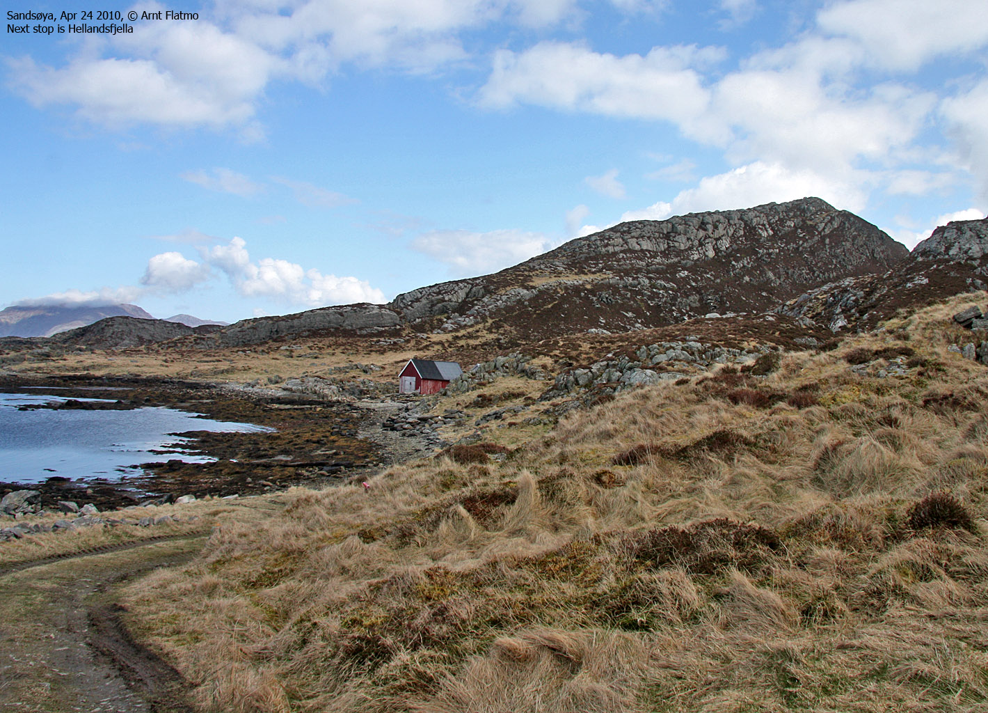
The route across Hellandsfjella
(Click for larger image)
Alternative 1 (primary route - from the east):
From the Voksa/Sandshamn junction on Sandsøya, drive 280 meters in the direction of Sandshamn. At a fork, turn left and drive 150 meters up to another fork (near the school - described for Rinden above). Turn right and drive 2,5km along Vågen to Våge. Locate the path (N62.26301 E5.44892) up to Hellandsfjella.
The path runs on the north side of the ridge for a little while, then on the ridge proper and up to the northernmost of the two Hellandsfjella tops (N62.26590 E5.43118) - approx 115-120m. The path continues south, then west to the highest point (N62.26529 E5.42828) - marked by a stick.
The starting point is approx. 25 meters, the vertical gain 200 meters, the total distance 1,4km and the estimated time is half an hour. This is a YDS class 1 route; no difficulties.
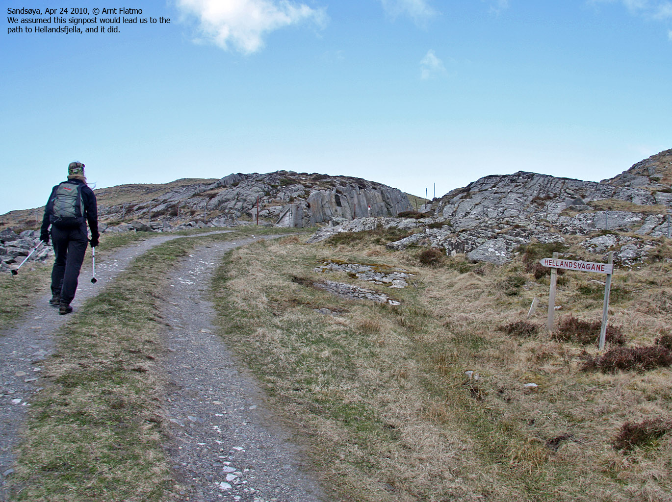
Alternative 2 (from the west):
From the Voksa/Sandshamn junction on Sandsøya, drive 280 meters in the direction of Sandshamn. At a fork, turn left and drive 150 meters up to another fork (near the school - described above). Turn right and drive 2,5km along Vågen to Våge. Turn left and drive 2km to the end of the road. Park here (N62.26166 E5.41434). This is also the trailhead for Dollsteinen. See above.
Walk 150 meters back the way you came, then turn left when you see the Hellandsvågane signpost. Descend down to the shore and follow a distinct ridge which takes you up to the Hellandsfjella high point.

The route across Hornet
(Click for larger image)
Alternative 1 (primary route - from the southeast):
From the Voksa/Sandshamn junction on Sandsøya, drive 280 meters in the direction of Sandshamn. At a fork, turn right and drive 1km (across the bay and the bridge) to another fork. Turn left, drive 100 meters and turn right again. Drive 300 meters up to a house with a barn (N62.25625 E5.47507). Look for a place to park.
The path runs on the back side of the barn, then continues upwards in the northwest direction to Hornet (N62.26200 E5.47261) - marked by a bolt and a stick.
The starting point (the barn) is approx. 65 meters, the vertical gain 200 meters, the total distance 1km and the estimated time is half an hour. This is a YDS class 1 route; no difficulties.
Alternative 2 (from the west):
From the Voksa/Sandshamn junction on Sandsøya, drive 280 meters in the direction of Sandshamn. At a fork, turn right and drive 1km (across the bay and the bridge) to another fork. Turn left, drive 1,6km in the direction of Våge until you see the Grøntua signpost. Find a place to park nearby.
Follow the path towards the ridge, then up the ridge, across Grøntua and to Hornet.

The route across Vorakletten and Voren
(Click for larger image)
Round trip suggestion:
From the Voksa/Sandshamn junction on Sandsøya, find parking nearby. Follow the road to the west for 500 meters, then turn right onto the path to Vorakletten (signposted "Kletten"). Follow the marked path for 650 meters up to the top - where you find an antenna.
From Vorakletten, follow the path to the south, then to the west - into the small valley between Vorakletten and Voren. Pass through a gate and follow the path up to the top of Voren.
Descend to the northwest and you will end up close to the Voksa/Sandshamn junction.
The starting point (the junction) is approx. 15 meters, the vertical gain 180 meters, the total distance 2,3km and the estimated time is half an hour. This is a YDS class 1 route; no difficulties.
Dollsteinen
(Click for larger image)
 westcoastpeaks.com
Other Møre & Romsdal mountains
Other Norwegian mountains
westcoastpeaks.com
Other Møre & Romsdal mountains
Other Norwegian mountains


