
Norwegian Mountains, Møre og RomsdalSkoratinden, 1002m (Rovdehornet)
|
| Fylke/Kommune : | Møre og Romsdal/Vanylven | ||||||||
| Maps : | 1119-II Volda (Statens Kartverk, Norge 1:50 000) | ||||||||
| Primary factor : |
Skoratinden: 334m Fossanipa: 108m Storhornet: 144m |
||||||||
| Hiked : | Aug 2009 | ||||||||
| See also : |
| ||||||||
| See also : | Other Vanylven mountains |

Skoratinden
(Click for larger image)
Without a doubt, Skoratinden is one of the most characteristic of the Vanylven peaks. The mountain is located above Rovdestranda shore, hence the alias Rovdehornet. Although Skoratinden looks steep and rugged from the Rovdestranda side, the mountain is easy to reach; the Årskogdalsvegen road takes you to the foot of the mountain (460m) - and the normal route to the summit offers no obstacles.
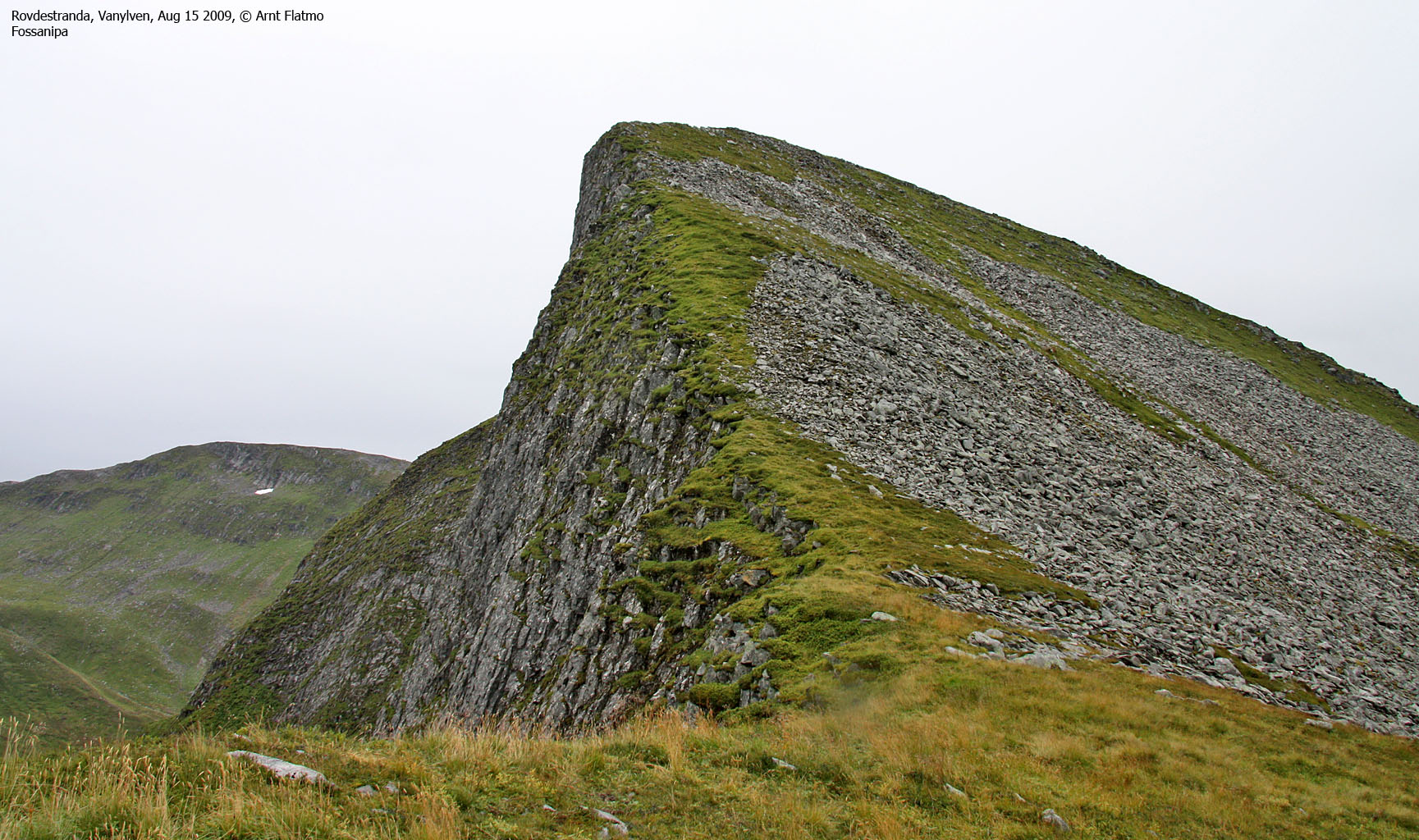
Fossanipa is Skoratinden's close neighbour to the south, and as the Skoratinden path runs through the Skoratinden - Fossanipa saddle, Fossanipa is a "bonus peak" which takes less than 30 minutes (up and down). Other tops that easily can be reached from this trailhead are Myrkevassegga and Storhornet. After just 500 meters on the path from the Skoratinden trailhead to Skåravatnet, you will see the Storhornet signpost. The path gradually fades away, but the terrain is easy to follow.

Skoratinden
(Click for larger image)
Skoratinden has a very rugged ridge towards the north. It doesn't seem that this ridge can be -easily- traversed from south to north without the safety of a rope, but the actual facts will be fully documented on this page (upon the next visit) in 2010.
However, it is clear that you can descend from Skoratinden, across point 888m (Økonomisk Kartverk) and to the col (gap) just north of point 795m (ØK) without (necessarily) needing a rope. A couple of pitches are very exposed and should only by attempted by those who are comfortable with this this type of terrain. See the trip report (link) below for further details.

Skoratinden
(Click for larger image)
Skoratinden (Norge 1:50,000: -, Økonomisk Kartverk: highest contour is 1000m, interpolated to 1002m, UTM 32 V 333816 6894698) has a primary factor of 334m towards the higher parent Snøhornet (1024m). The defining saddle (approx. UTM 32 V 332775 6894004) is found between Skoratinden and Storhornet (just north of Skåravatnet). Ref. Økonomisk Kartverk (5m contours), the saddle is within the range 665-670m, interpolated to 668m.
Note that Norge 1:50,000's point 999m is not the Skoratinden high point.
Fossanipa (Norge 1:50,000: 906m, Økonomisk Kartverk: highest contour is 905m, UTM 32 V 333964 6893642) has a primary factor of 108m towards the higher parent Skoratinden. The defining saddle (approx. UTM 32 V 333789 6893872) is found in the saddle between Skoratinden and Fossanipa. Ref. Økonomisk Kartverk (5m contours), the saddle is within the range 795-800m, interpolated to 798m.
Storhornet (Norge 1:50,000: 866m, Økonomisk Kartverk: 867m, UTM 32 V 332043 6894409) has a primary factor of 144m towards the higher parent Trollkoppehornet. The defining saddle (approx. UTM 32 V 331563 6893771) is found in the saddle between these two tops. Ref. Økonomisk Kartverk (5m contours), the saddle is within the range 720-725m, interpolated to 723m.

GPS track profile
(Click for larger image)
Google's interactive map. You can zoom, pan and click on the markers.
|
|
|
| This disclaimer is regarding all of the literature and instructional guides posted on the westcoastpeaks.com website. These instructions are guidelines only, and should not be used in lieu of common sense or judgment when attempting any of the actions involved or instructed. Westcoastpeaks nor myself will not be liable nor will it indemnify any form of compensation to anyone who has injured, harmed or even killed themselves or others while following any of the instructions written within the website. It should be noted by any persons willing to undertake any of the instructions provided that mountains offer varying levels of risk, regardless of size or incline. Risks to be considered are as follows but not limited to: wild animals, weather, the terrain, bad judgment, inappropriate or insufficient equipment, improper training or experience and of course, bad luck... |
|
Route 1: Rovdestranda - Skoratinden (summer/autumn)
|
|
This route description is valid per Aug
2009
Access
(all distances are approx. distances)
The nearest bigger city is Ålesund. From Ålesund, you have a number of options, but most involve two ferries. Here are a few alternatives:
a) Ålesund - RV61 Sulesund-Hareid ferry - Ulsteinvik - Årvika (Gurskøya) - Koparnes ferry - Eidså - RV652 Syvden - Rovdestranda
b) Ålesund - RV61 Sulesund-Hareid ferry - Ulsteinvik - Eiksund tunnel - E39 Volda - Volda - Folkestad ferry - Dalsfjorden - Rovdestranda
c) Ålesund - E39 Solavåg-Festøy ferry - Ørsta - Volda - Volda - Folkestad ferry - Dalsfjorden - Rovdestranda
Note that you can avoid the Volda - Folkestad ferry by driving around Austefjorden
If you choose option a) then drive Koparnes to Eidså (6,7km). Turn left onto RV652, pass Syvden (11,7km), Syvdsneset (22,9km) and turn right (27,7km) onto the Årskogdalsvegen mountain road at Rovde.
If you choose option b), the distance between Lauvstad and the Årskogdalsvegen junction in Rovde is 14,3km.
The mountain road: Drive 300m and turn right at a junction. Continue 1,2km to the self-serviced toll booth (NOK 30,- for passenger cars). Continue 3,4km up to the parking at 460m (elev.) Pass (and close) a few gates along the way. Expect (a serious amount of) sheep dirt on this road. Your car may need "detoxification" afterwards..
The route

The route to Skoratinden and Fossanipa
(Click for larger image)
From the parking, follow the path south into the valley. At 530m, the path forks. Go straight ahead for Skoratinden (the path to the right goes to Storhornet). The path crosses a slab section before it climbs up to Lake Skåravatnet.
Turn left by the cabins and follow the path (which is a bit vaguer now) towards the Skoratinden - Fossanipa saddle. From this saddle, you have the option to visit Fossanipa (YDS class 2). There is no distinct path up Fossanipa's north ridge, but it is fairly easy to ascend. Fossatinden summit is marked by a proper cairn.
Back in the saddle, proceed up Skoratinden's south ridge and to the summit, which is marked by a proper cairn. Descend your ascent route or take the fast route directly down to the valley.
The north ridge

The north ridge
(Click for larger image)
This section will be completed when the north ridge has been fully traversed, but here are some notes;
From the summit, descend the north ridge to a col at approx. 870m. The last section above the col is quite steep, but there is an exposed, but easier route on your right-hand side. From the col, scramble up to point 888m (height from Økonomisk Kartverk, UTM 32 V 333584 6895038). Continue across a grassy "hump" (UTM 32 V 333577 6895057) and proceed to the second ridge top (UTM 32 V 333549 6895129). There is one exposed and one "awkward" point between these ridge tops. Descend towards the col below point 795m. The ridge drops steeply into this col too, and there does not seem to be an easier alternative. A rope is probably necessary to get to the col. Then follows a scramble (or climb) up to point 795m, but information about this section will be described once the ridge has been fully traversed.
|
Route 2: Rovdestranda - Storhornet (summer/autumn)
|
|
This route description is valid per Aug
2009
Access
Same access as for Skoratinden. See above.
The route
Follow the route from the parking towards Skåravatnet for 450m meters. Turn right when you see the Storhornet signpost. The path upwards is not very visible and is not marked (except for some iron poles), but the terrain is easy and the direction should be obvious.

The route, as seen in Google Earth
(Click for larger image)
 westcoastpeaks.com
Other Møre & Romsdal mountains
Other Norwegian mountains
westcoastpeaks.com
Other Møre & Romsdal mountains
Other Norwegian mountains
¹ Thanks to Bjørn Skoge who informed me about the Kvanndalshornet name.


