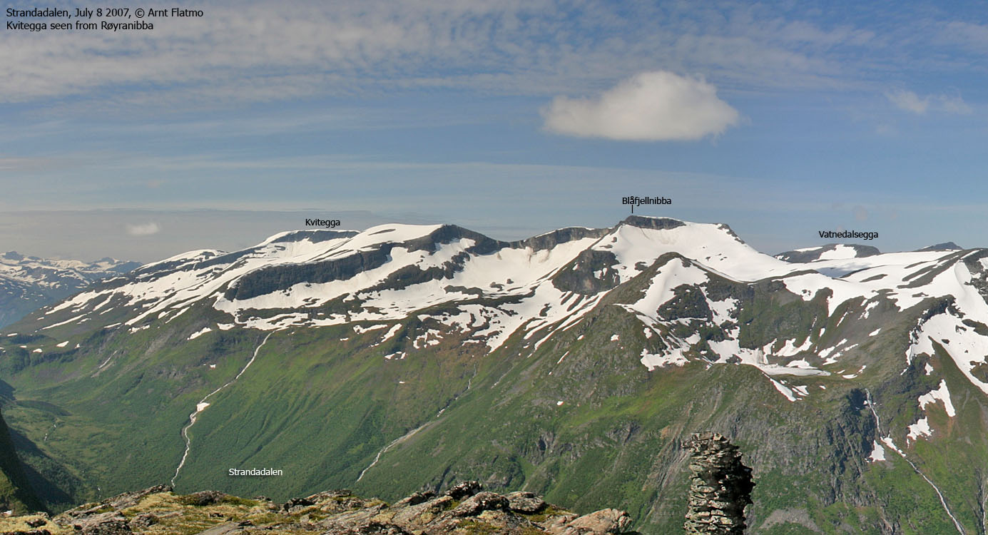

Norwegian Mountains, Møre og RomsdalKvitegga, 1489m
|
| Fylke/Kommune : | Møre og Romsdal/Stranda | ||||||||
| Maps : | 1219-II Geiranger (Statens Kartverk, Norge 1:50 000) | ||||||||
| Primary factor : |
Kvitegga: 704m Blåfjellnibba: 132m Vatnedalsegga: 170m Blåfjellnibba SE-1: 81m Vatnedalsegga NE-1: 122m |
||||||||
| Hiked : | July 2008 | ||||||||
| See also : |
| ||||||||
| See also : | Other Stranda mountains |

Kvitegga, Blåfjellnibba and Vatnedalsegga surround the Litlemoldskreddalen valley - a side valley to the Synnylvsmoldskreddalen valley, which in turn connects to the Strandamoldskreddalen valley in the pass by Synnylvsvatnet. Strandadalen valley is to the east of these mountain tops. The route described on this page, is a round trip across the peaks surrounding Litlemoldskreddalen.
The mountain range stretches to the north, towards Emdalstindane and Svartetindane, and Kvitegga is the highest top in this mountain range. This particular Kvitegga should not be confused with the higher Kvitegga (1707m) 9,5km to the southwest. You will also find a Kvitegga 9,7km to the north (next to Svartetindane), although locals refer to this ridge as Kvitfjellsegga.

None of the tops surrounding Litlemoldskreddalen are difficult to get to, on their easiest routes. In fact, the tops offer very nice terrain for cross country skiing. A good starting point, summer and winter, is Ljøsætra and up Ljødalen. Another good trailhead could be Rindalen, via Rindalseggene. A third option is from the north, via Emdalsdalen. See fjellinordvest.net for description of some of these routes. This page will describe a summer route from Synnylvsmoldskreddalen.
Kvitegga (Norge 1:50,000: 1489m, Økonomisk Kartverk (ØK): 1489m, UTM 32 V 388809 6890666) has a primary factor of 704m towards the higher parent mountain Skruven (1584m). The defining saddle (approx. UTM 32 V 386684 6893013) is found south of Synnylvsvatnet (this lake is draining north). Ref. Økonomisk Kartverk map (10m contours), the saddle is within the range 780-790m, interpolated to 785m.
GPS measurement on the summit cairn read 1490m, averaged over a 5-minute period (error margin not recorded).
Blåfjellnibba (Norge 1:50,000: 1487m, Økonomisk Kartverk (ØK): -, UTM 32 V 389393 6893644) has a primary factor of 132m towards the higher parent mountain Kvitegga (1489m). The defining saddle (approx. UTM 32 V 389477 6892965) is found between Blåfjellnibba and point 1451m. Ref. Norge 1:50,000 map (20m contours), the saddle is within the range 1340m-1360m, interpolated to 1355m based on the actual terrain and GPS tracks.
GPS measurement on the summit cairn read 1491m, averaged over a 5-minute period (error margin not recorded).
Blåfjellnibba SE-1 (Norge 1:50,000: 1451m, Økonomisk Kartverk (ØK): -, UTM 32 V 389799 6892490) has a primary factor of 81m towards the higher parent mountain Kvitegga (1489m). The defining saddle (approx. UTM 32 V 389257 6891959) is found between point 1451m and point 1454m. Ref. Norge 1:50,000 map (20m contours), the saddle is within the range 1360m-1380m, interpolated to 1370m.
GPS measurement on the summit cairn read 1457m, averaged over a 5-minute period (error margin not recorded).
Vatnedalsegga (Norge 1:50,000: 1420m, Økonomisk Kartverk (ØK): -, UTM 32 V 387654 6893990) has a primary factor of 170m towards the higher parent mountain Blåfjellnibba (1487m). The defining saddle (approx. UTM 32 V 388593 6893991) is found between Vatnedalsegga and Blåfjellnibba. Ref. Norge 1:50,000 map (20m contours), the saddle is within the range 1240m-1260m, interpolated to 1250m.
GPS measurement on the summit cairn read 1426m, averaged over a 5-minute period (error margin not recorded).
Vatnedalsegga NE-1 (Norge 1:50,000: 1372m, Økonomisk Kartverk (ØK): -, UTM 32 V 388307 6894850) has a primary factor of 122m towards the higher parent mountain Vatnedalsegga (1420m). The defining saddle (approx. UTM 32 V 388070 6894608) is found between these two tops. Ref. Norge 1:50,000 map (20m contours), the saddle is within the range 1240m-1260m, interpolated to 1250m.
GPS measurement on the summit read 1375m, averaged over a 5-minute period (error margin not recorded).
The "competing" saddles between Vatnedalsegga and point 1372, and point 1372m and Blåfjellnibba have both been interpolated to 1250m. GPS tracks did not positively point out the deepest saddle, so an arbitrary choice of saddle was made.
Google's interactive map. You can zoom, pan and click on the markers.
|
|
|
|
Route 1: Synnylvsmoldskreddalen - All tops (summer/autumn)
|
|
Access
(all distances are approx. distances)
The nearest larger city is Ålesund. From Ålesund, follow highway E39 towards Bergen, and then highway RV60 (Stranda) to the Magerholm - Ørsneset ferry. This ferry runs quite often; every 20 minutes during the busy hours of the day. From Ørsneset, drive RV60 to Stranda (34,3Km). Turn south (right) and continue on RV60 to Hellesylt (27,4km). Proceed 700m on RV60 and turn right towards Rindal.
Follow the switchbacks up to the houses at the valley head (1,5km). Pay toll at an unmanned booth, then drive 4,2km into Synnylvsmol(d)skreddalen. Locate the Litlemoldskreddalen trail sign along the road, just before a cabin area.
The route
Part of the upper route

(Click for larger image)
The path, which is hard to see at first, passes the southernmost cabin and heads towards Litledalsfossen. On the way to the waterfall, you should be able to see red paint on trees and rocks. Follow the path up the steep forest. At approx. 620m, a path takes you into the Litledalsfossen basin. A spectacular sight! Once you're above the forest, make your way across the river and head up the long hillside to Kvitegga.
From Kvitegga, the round trip is quite obvious. You follow the high route all the way (ref. the above picture). You'll find cairns, small or bigger, on all of the tops. The descent from point 1372m can become quite steep if you head down the steepest section.
This route does not quite match the route described in the trip report below. But whatever you do, don't attempt the forest on the east side of the river from Litlemoldskreddalen!
 westcoastpeaks.com
 Other Møre & Romsdal mountains
 Other Norwegian mountains