
Norwegian Mountains, Sogn og Fjordane
Krakhellenipa, 569m
Pollatinden, 541m
Ulvegreina, 448m
Dumbetinden, 459m
Hardbakkefjellet, 232m (Ravnenipa, Ramnipa)
Husefjellet, 168m
Husefjellet, 160m
Urdanipa, 133m
Liafjellet, 242m (Kleberget, Skarpenesfjellet)
Vardefjellet, 315m
Håfjellet, 202m
Sperrefjellet, 155m
| Fylke/Kommune : | Sogn og Fjordane/Solund | ||
| Maps : | 1117-III Solund (Statens Kartverk, Norge 1:50 000) | ||
| Primary factor : |
Krakhellenipa: 569m (High
point Sula) Ulvegreina: 98m Dumbetinden: 269m Hardbakkefjellet: 182m Husefjellet (168m): 138m Husefjellet (160m): 130m Pollatinden: 511m Urdanipa: 103m Liafjellet: 199m Vardefjellet: 315m (High point Steinsundøyna) Håfjellet: 202m (High point Ytre Sula) Sperrefjellet: 140m |
||
| Hiked : | June 2011 | ||
| See also : |
| ||
| See also : | Other Sogn og Fjordane mountains |

Solund scenery
(Click for larger image)
Introduction
Solund is a municipality that comprise a number of islands that are located where the famous Sognefjord meets the Atlantic ocean. The largest islands are (not in particular order); Sula, Ytre Sula, Steinsundøyna, Losna, Rånøyna, Nesøyna and Ospa. Solund is the smallest municipality in Sogn og Fjordane county and is also the only municipality that is not connected to mainland Norway.
This group of islands is an Eldorado for outdoor activities such as hiking, climbing and kayaking. Telemark skiers might have a short season (...) The purpose of this page is to point you to some of the most accessible coastal tops if you have a couple of days to spend out here. In fact, you could live here a lifetime and still not have time to explore all the interesting stuff on these islands.
One thing you're guaranteed to remember are the views - up and down the coastline. And on clear days, you can see the string of oil rigs out at sea. The Rundemanen and Ulriken towers in Bergen are also easy to identify (especially through binoculars) - 80-some kilometers to the south.
")
Part of our amazing coastline (view is north)
(Click for larger image)
How to get there:
Take the Rysjedalsvika (north side of Sognefjorden) - Rutledal (south side) - Krakhella (Sula) ferry. At Rutledal, the ferry crew will probably instruct you turn the car around. This ferry will stop at Losna if you give them a signal to do so. Remember to negotiate pick-up...
You travel from Sula to Steinsundøyna and Rånøyna across bridges. You travel to Ytre Sula on the Daløy - Halldorsneset ferry. Per 2011, you don't have to pay for this ride (!). The other islands - such as Nesøyna, Storøyna, Olderøyna, Lågøyna, Hågøyna, Huvøyna, etc. requires that you organize transport privately.

Utvær and an oil rig
(Click for larger image)
Accomodation:
The general advice is to book accommodation before you travel to Solund. There are not too many places to choose between (especially in summer). One recommendation is Solund Leilighetshotell - Internatet (+47 91 18 98 22) located in Hardbakke - the municipality centre.

Hardbakke
(Click for larger image)
Google map
Google's interactive map. You can zoom, pan and click on the markers.
|
|
|

Trail descriptions
| This disclaimer is regarding all of the literature and instructional guides posted on the westcoastpeaks.com website. These instructions are guidelines only, and should not be used in lieu of common sense or judgement when attempting any of the actions involved or instructed. Westcoastpeaks nor myself will not be liable nor will it indemnify any form of compensation to anyone who has injured, harmed or even killed themselves or others while following any of the instructions written within the website. It should be noted by any persons willing to undertake any of the instructions provided that mountains offer varying levels of risk, regardless of size or incline. Risks to be considered are as follows but not limited to: wild animals, weather, the terrain, bad judgement, inappropriate or insufficient equipment, improper training or experience and of course, bad luck... |
The route descriptions are valid per June 2011.

The Solund tops featured on this page
(Click for larger image)
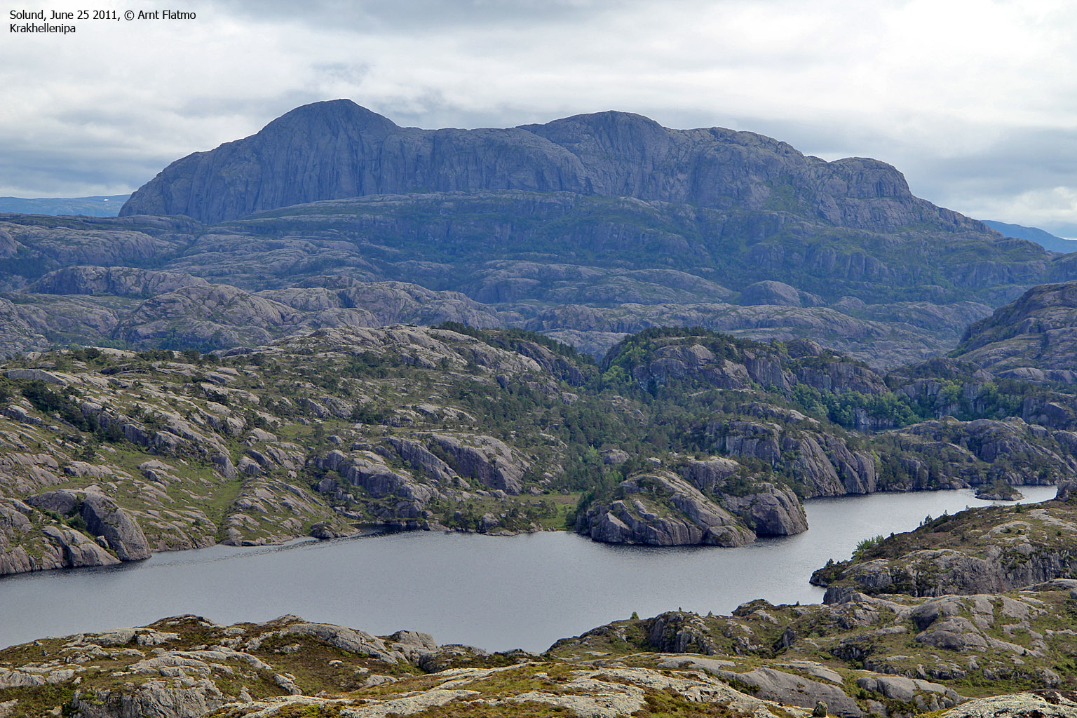
| Krakhellenipa
(569m) (highest peak on Sula island and in Sula municipality) |
Sula island | Shortest route (?): |
|
Krakhellenipa seen from Husefjellet |
UTM: 32 V 284586 6782949 |
Distance (to summit); 3,6km. Time:
2
hours. Vertical gain: 550m. Classification: Easy hike along a visible path.
(YDS class 1). Route illustration
here. Start the hike at the "Krakhella" signpost (N61.12290 E4.96788) - 5,1km east from Krakhella. Follow marked path towards Kløstreheia until the path turns north (it goes back to the road). Turn south (N61.12207 E4.98029) and follow a cairned path that runs up the grassy slopes up the mountain. Pass Mednipa on the south side and follow cairns across the plateau to the summit cairn (N61.12186 E5.00012) |
|
|
||
| Ulvegreina
(448m) |
Sula island | Standard route: |
|
Ulvegreina seen from Dumbetinden |
UTM: 32 V 280652 6782358 |
Distance (to summit); 3,7km
(3,1km along service road), Time: 1 hour. Vertical gain: 350m. Classification: Very easy hike (YDS
class 1). From Krakhella, follow the main road (606) until you reach the Eide/Hardbakke junction. Turn left towards Eide and drive 3km. You see the mountain service road (N61.09029 E4.93463) on the left-hand side of the road. This road is normally closed by a gate, but if the gate is not locked, you can ask the landowner in Kråkevåg for permission to drive up the road. The summit (N61.11439 E4.92798) is located 500m N/NW of the antenna and is marked by a medium-sized cairn. |
|
|
||
| Dumbetinden
(459m) |
Sula island | Standard route: |
|
Dumbetinden seen from Ulvegreina |
UTM: 32 V 281368 6782902 |
Distance (to summit); 4km
(2,5km along service road), Time: 1,5 hours. Vertical gain:
420m. Classification: Easy hike (YDS
class 1). Same access route as for Ulvegreina (above). 700 meters before the Ulvegreina antenna, locate the "Dumbetinden" signpost on the right-hand side of the mountain road. Descend into the valley, cross it and follow a visible path up Dumbetinden's south ridge. The summit (N61.11966 E4.94059) is marked by a medium-sized cairn. Visit the small cave in the valley. |
|
|
|
|
| Hardbakkefjellet
/ Ravnenipa
(232m) |
Sula island | North ridge route: |
|
Hardbakkefjellet seen from Liafjellet |
UTM: 32 V 275973 6778282 |
Distance (to summit);
1,8km. Time: 1 hour. Vertical gain: 200m. Classification:
For the most part easy, but one spot requires the use of hands (YDS
class 3). From Krakhella, follow 606 towards Hardbakke. 1,8km after you've passed the road to Solund Verft - and before you reach Lake Storevatnet (on your right), locate a small turnout on the left-hand side of the road (N61.07913 E4.85770). Follow a forest path - first to the south, then to the west until you reach a pass where you see the Ravnenipa signpost. Follow the marked trail all the way to the summit - marked by a medium-sized cairn. The "hardest" point of the route requires the use of hands, but there is no exposure. |
|
|
|
|
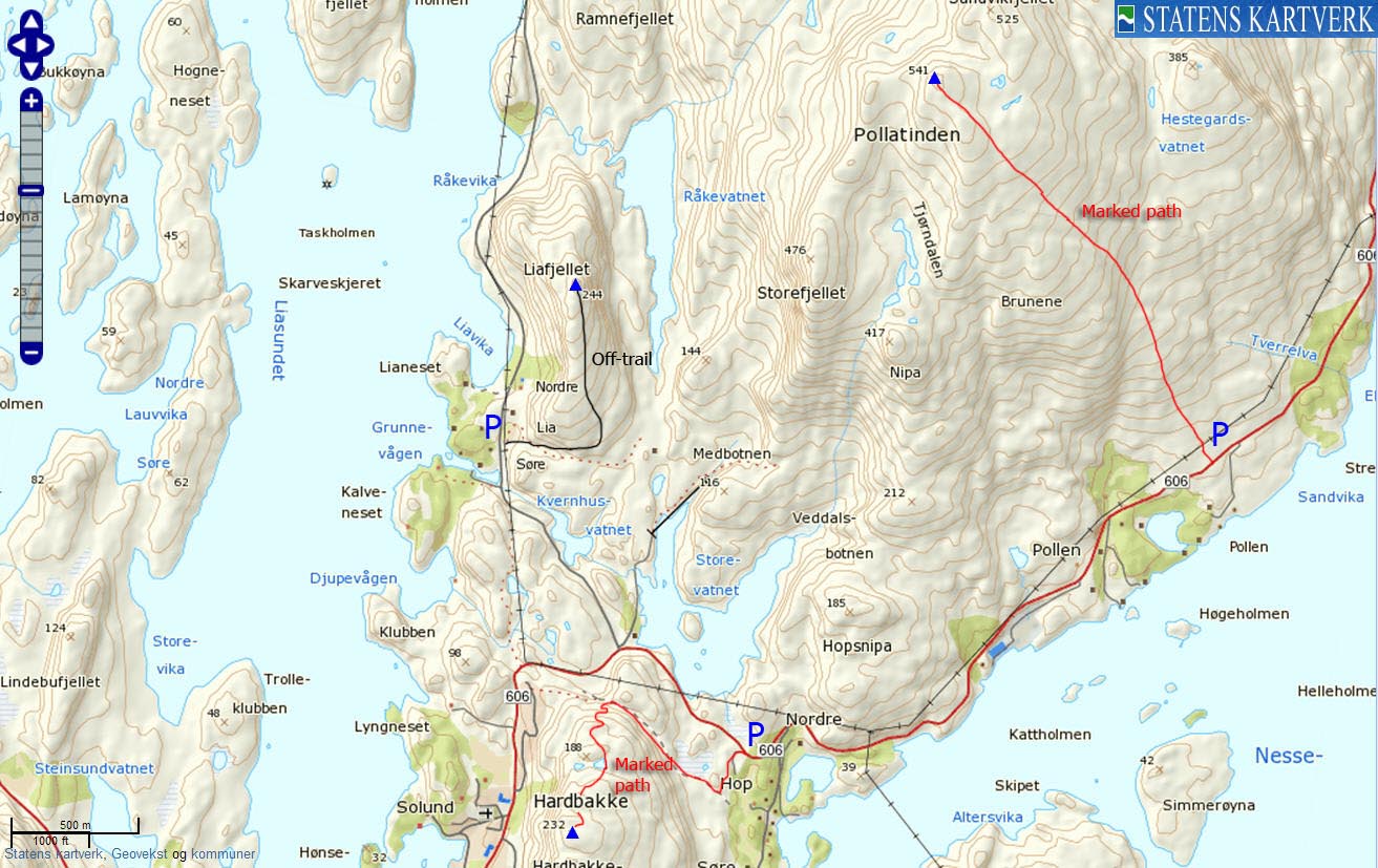
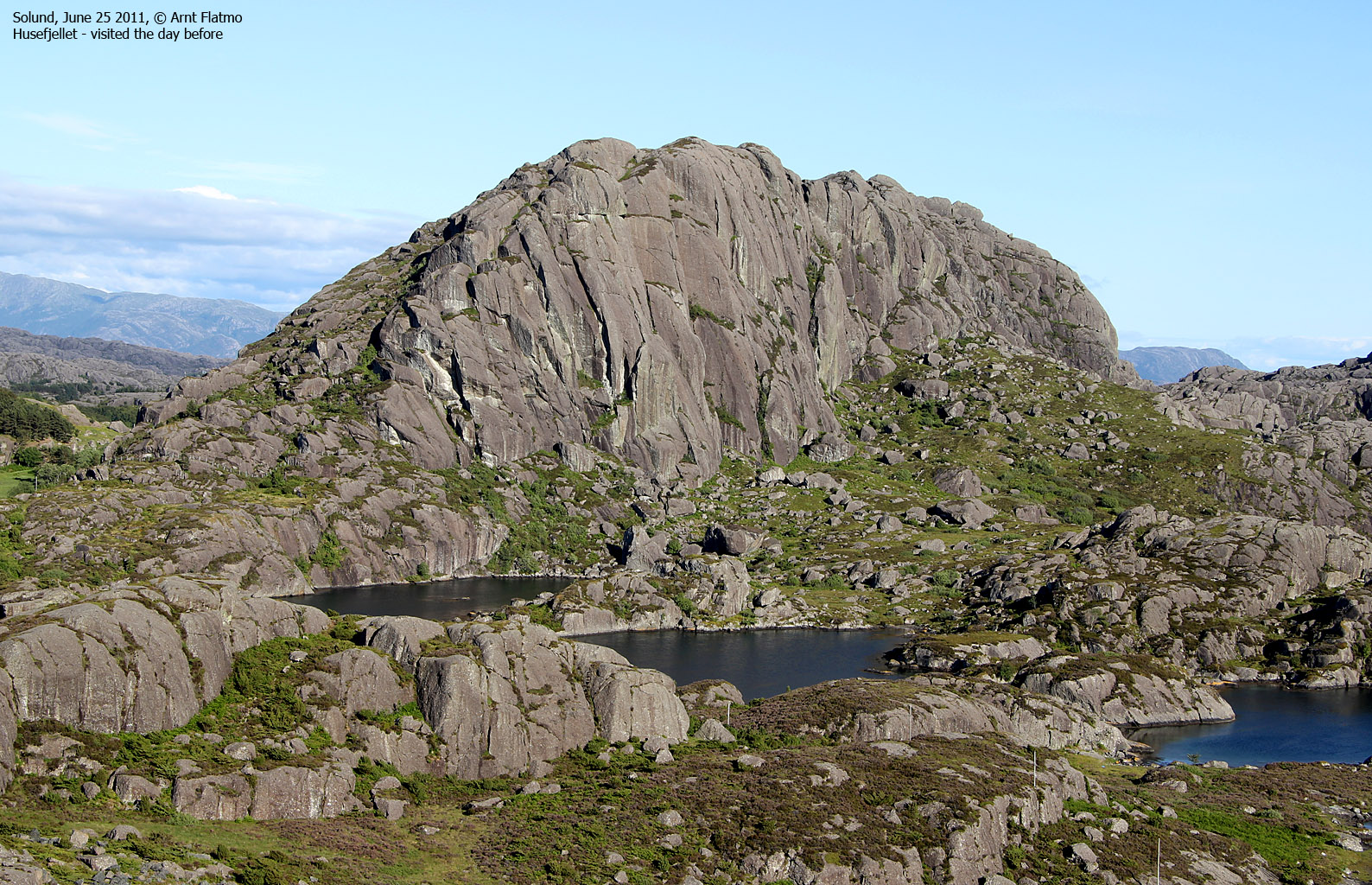
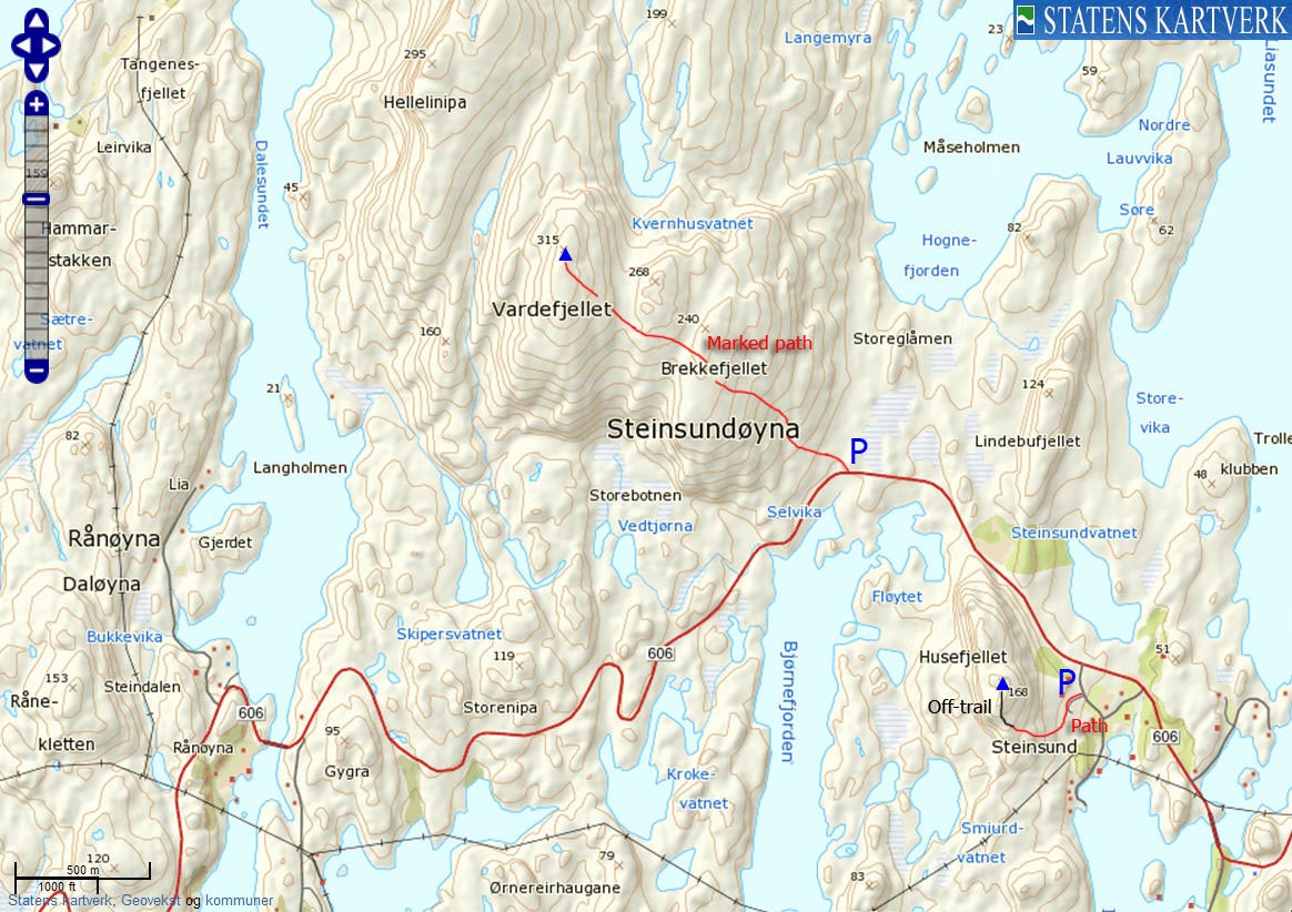
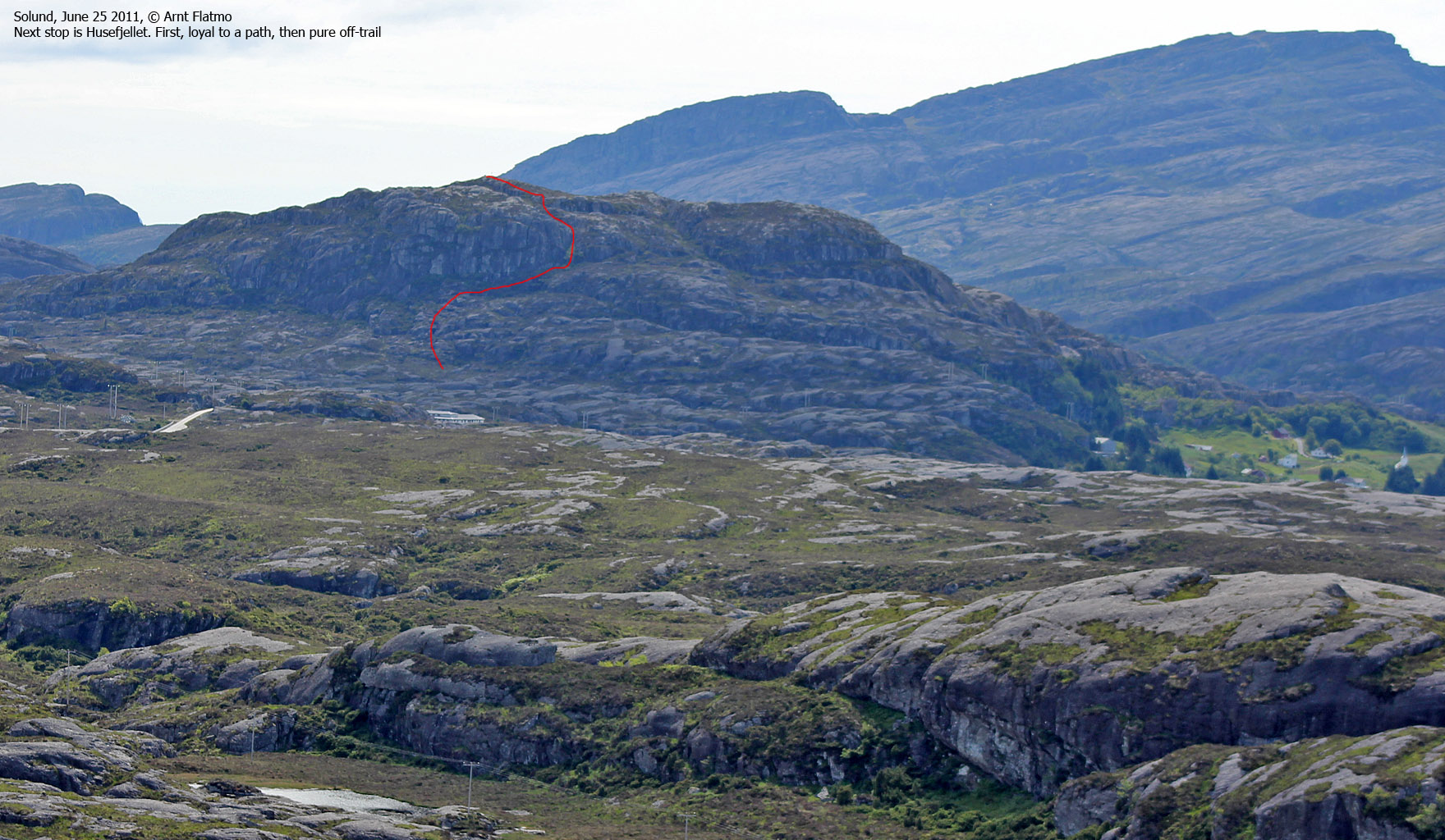
| Husefjellet
(168m) |
Steinsundøyna island | South ridge route: |
|
Husefjellet seen from Vardefjellet |
UTM: 32 V 273802 6777783 |
Distance (to summit);
0,6km. Time: .5 hours. Vertical gain: 150m.
Classification: Easy, mixed path and off-trail (YDS class 2). Route illustration
here. From Hardbakke, drive towards Steinsundøyna. 800 meters after the bridge, turn left onto a road that leads down to the fjord. Stop after 120 meters. Ask for permission to park in front of a barn (N61.06946 E4.81250). Pass through a gate by the barn, then locate yet another gate on the far side of the field - to avoid the electrical fence. From the 2nd gate, follow a vague path upwards. After the 3rd gate, the vague path fades away and you'll have to go off-trail up the summit (N61.06967 E4.80609), marked by a small cairn - 30 meters west of the trig. point. Locate the plaque near the summit for info about this mountain. |
|
|
|
|
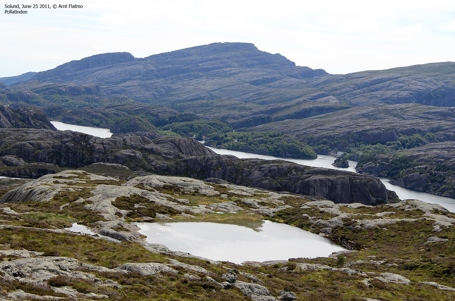
| Pollatinden
(541m) |
Sula island | Standard route: |
|
Pollatinden seen from Husefjellet |
UTM: 32 V 277139 6781444 |
Distance (to summit);
2,3km. Time: 1,5 hours. Vertical gain: 500m.
Classification: Easy (YDS class 1). Route illustration
here. From Hardbakke, drive towards Steinsundøyna. 800 meters after the bridge, turn left onto a road that leads down to the fjord. Stop after 120 meters. Ask for permission to park in front of a barn (N61.06946 E4.81250). Pass through a gate by the barn, then locate yet another gate on the far side of the field - to avoid the electrical fence. From the 2nd gate, follow a vague path upwards. After the 3rd gate, the vague path fades away and you'll have to go off-trail up the summit (N61.06967 E4.80609), marked by a small cairn - 30 meters west of the trig. point. Locate the plaque near the summit for info about this mountain. |
|
|
|
|
| Urdanipa
(133m) |
Sula island | Standard route: |
|
Urdanipa seen from the north |
UTM: 32 V 280322 6792385 |
Distance (to summit);
0,7km. Time: .5 hours. Vertical gain: 100m.
Classification: easy (YDS class 1). From Krakhella, drive towards Hardbakke. Turn left at the Leknessundet fork and drive as far as the road takes you for general sightseeing. The (vague) path (N61.20307 E4.90366) begins 1,2km before the road fork at Leiknessundet. Follow it to the east for 400 meters, then follow the south ridge up to the summit (N61.20400 E4.91024) - marked by a trig. point and a proper cairn. |
|
|
|
|
| Husefjellet
(160m) |
Sula island | Standard route: |
|
Husefjellet seen from Urdanipa |
UTM: 32 V 279756 6788611 |
Distance (to summit);
1km. Time: .5 hours. Vertical gain: 140m.
Classification: scrambling (YDS class 3). Same access as for Urdanipa (above). On your way towards Leknessundet, turn left at the Hersvikbygda fork. After 500 meters (in a sharp curve), find parking and the Husefjellet signpost (N61.17494 E4.90009). Follow the path for 500 meters, then break away in direction of the steepest part of the mountain. Locate a gully that leads you straight to the summit (N61.16988 E4.90413). This gully requires scrambling. There are indeed easier routes, and we expect that the path you started on - eventually takes you to the top. |
|
|
|
|
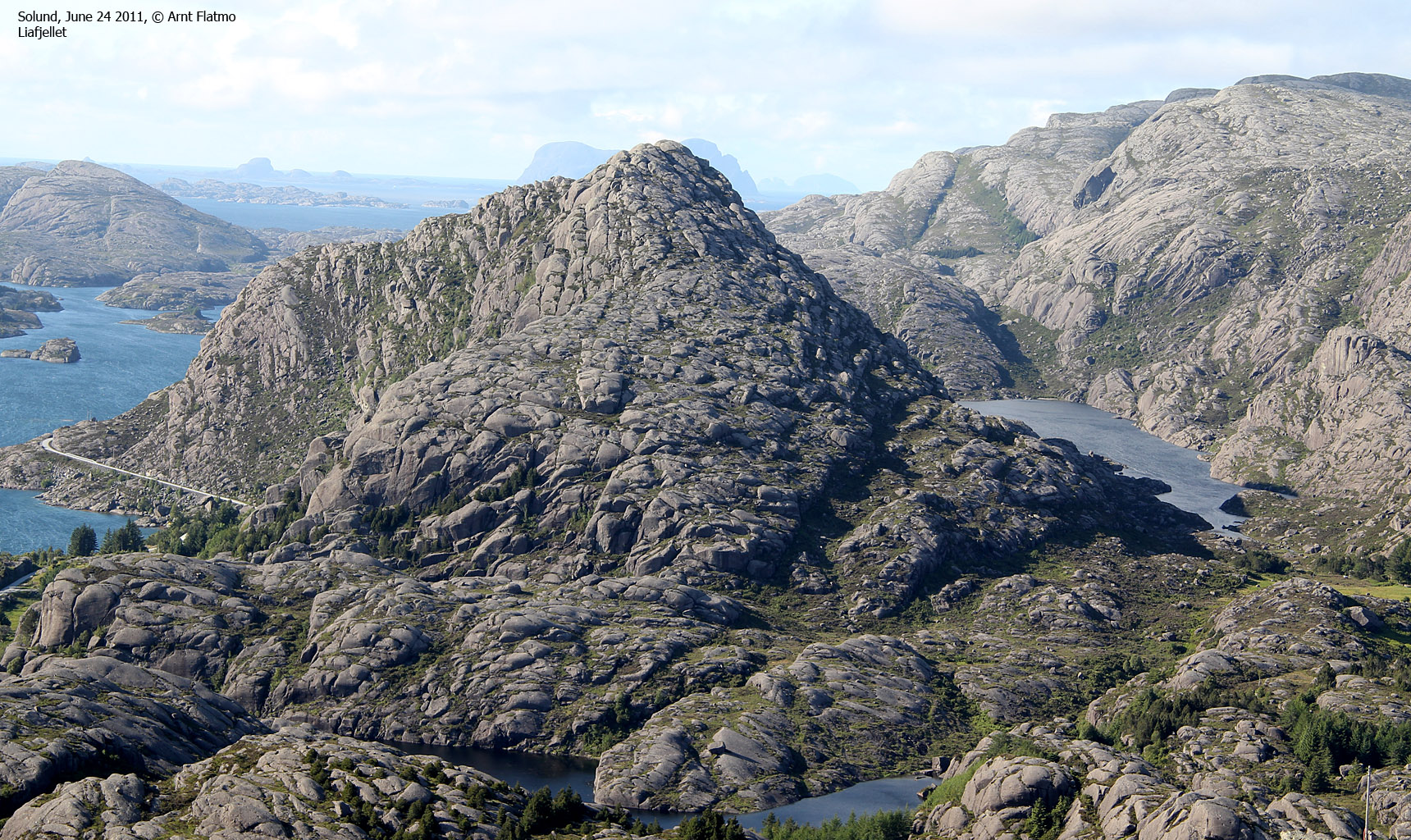
| Liafjellet
(168m) |
Sula island | Standard route: |
|
Liafjellet seen from Hardbakkefjellet |
UTM: 32 V 275784 6780503 |
Distance (to summit);
1,2km. Time: 1 hour. Vertical gain: 220m.
Classification: scrambling (YDS class 2). Route illustration
here. Just before Hardbakke, turn right towards Stranda. Drive 1km to Søndre Lia. Find parking alongside the road - somewhere. Head into the forest (N61.08891 E4.83605)and follow a small valley until you find a place to easily access Liafjellet's south ridge. Follow the ridge up to the summit (N61.09503 E4.84006) |
|
|
|
|
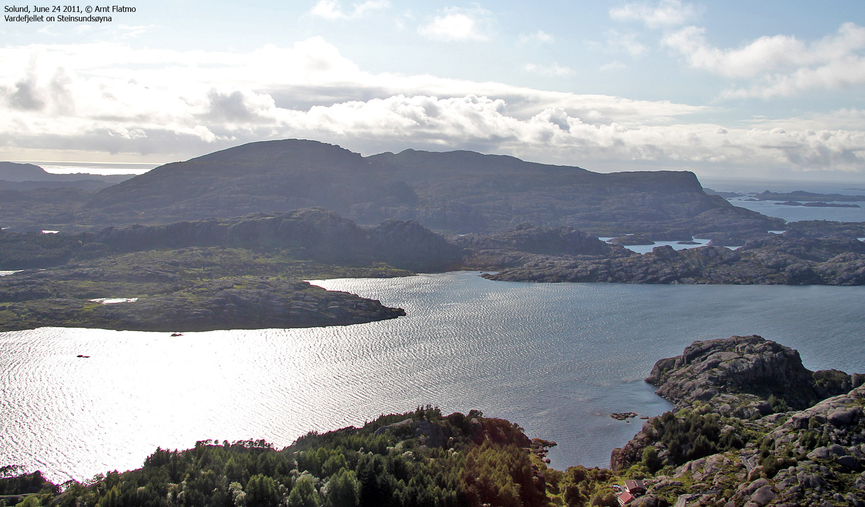
| Vardefjellet
(315m) |
Steinsundøyna island | Standard route: |
|
Vardefjellet seen from Hardbakkefjellet |
UTM: 32 V 271996 6779222 |
Distance (to summit);
1,8km. Time: 1 hour. Vertical gain: 300m.
Classification: easy (YDS class 1). Halfway between Hardbakke and Daløy, locate the Stokkevåg signpost (N61.07588 E4.79318) by Bjørnefjorden. Once on the trail, turn left almost immediately and follow a marked path up to Vardefjellet. The path passes to the south of Brekkefjellet and point 268m. Vardefjellet summit (N61.08139 E4.77154) is located 45m south of the trig. point, and is marked by a couple of rocks. |
|
|
|
|
| Håfjellet
(202m) |
Ytre Sula island | Standard route: |
|
Håfjellet seen from the ferry |
UTM: 32 V 269447 6773647 |
Distance (to summit);
2,2km. Time: 1-1,5 hours. Vertical gain: 200m.
Classification: easy (YDS class 2). Take the ferry to Ytre Sula and turn left in the first major fork after 1,1km. Drive to Nåra island and find parking on a small turnout (N61.01464 E4.73961) on the left-hand side of the road - 100 meters before the bridge to Nåra. Follow a vague path across Stordalsfjellet and Litle Håfjellet. This path descends into Askedalen and climbs Håfjellet's south ridge along a faint path. The summit (N61.02999 E4.73116) is marked by an antenna and a trig. point. |
|
|
|
|
| Sperrefjellet
(155m) |
Ytre Sula island | Standard route: |
|
On Sperrefjellet |
UTM: 32 V 267556 6777630 |
Distance (to summit);
1,2km. Time: 1 hour. Vertical gain: 150m.
Classification: easy (YDS class 1). Take the ferry to Ytre Sula and turn left in the first major fork after 1,1km. Drive 550m and park by the Sperrefjellet signpost (N61.05687 E4.69418). Follow a marked path up to Ytreheia - 148m (N61.06028 E4.68931). Continue north for 600m up to Midtheia - the highest point on Sperrefjellet (N61.06454 E4.69141). Descend your ascent route or continue east for 270m to another small top (N61.06501 E4.69460) - marked by a few cairns. The shortest route between Midtheia and this top is not "straightforward". Descend to the southeast and join the road at Otretjørna. |


Pictures and Trip reports:
- Fonnaheia, May 17 2022
- Krakksnova, Øykjefjellet, Dyrefjellet, Hamnefjellet, May 15-16 2022
- Krakksnova, Øykjefjellet, Dyrefjellet, Hamnefjellet, May 15-16 2022
- Hammarstakken, Rånekletten, Hågøytinden, Færøytinden, Hogneskjelfjellet, May 13-14 2022
- Håfjellet and Sperrefjellet on Ytre Sula, June 26 2011
- Pollatinden, Urdanipa, Husefjellet, Liafjellet, Råkeneset, Vardefjellet, June 25 2011
- Krakhellenipa, Ulvegreina, Dumbetinden, Hardbakkefjellet, Husefjellet, June 24 2011
- Krakhellenipa attempt, July 10 2004
 westcoastpeaks.com
Other Sogn og Fjordane mountains
Other Norwegian mountains
westcoastpeaks.com
Other Sogn og Fjordane mountains
Other Norwegian mountains