
|

Steinhusfjellet seen from Tverrvassfjellet trail(No Javascript) |
Together with Stussfjellet, Tverrvassfjellet and Gråsida, Steinhusfjellet is best reached from Stusdal, a neighbour valley to Romarheimsdalen where highway E39 runs. To clear up any name confusion - on all these web pages I have referred to "Stussdal", as written on the M711 map. The correct name is "Stusdal", as on the roadsign by highway E39.
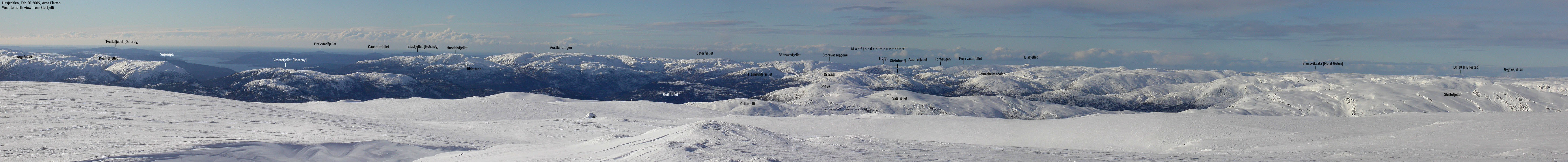
Steinhusfjellet has higher mountains both to the west, north and east. As such, it is not the best viewpoint you may find in this region. Still, it is a central mountain, and the views are not all bad. Ref. my wide panorama further down on this page, the views are pretty extensive, and you can see both Bergsbukken in Bergsdalen and Tveitakvitingen on Kvamskogen.
I have not been able to locate any trails up the mountain, and the mountain is probably not much visited. The route described on this page is off-trail, but it fairly easy terrain.
Primary factor:
Steinhusfjellet has a primary factor of 169m towards the higher Gråsida (the neighbour mountain). Økonomisk Kartverk (5m contours) map states that the 465m contours define the saddle. The saddle height has been interpolated to 463m.
Notes: Class ratings are in reference to YDS. Click here for more information.
The trails described below are not necessarily the *easiest* trails to this mountain.
|
Stusdal - Steinhusfjellet round-trip (summer)
|
|
From Bergen, follow highway E39 northbound (Førde/Ålesund). Drive across Nordhordlandsbrua and pay toll on the other side - NOK 45,- (for passenger cars - 1 driver) per July 2004. Follow highway E39 for approx. 41,6Km, then turn left towards "Stusdal". Follow the Stusdal road upwards. Pay road toll after 1Km. NOK 20,- per July 2004. The toll is self-served. A mailbox is found on one on the buildings at Stusdal. Pay here. At 1,2Km you arrive a 3-way junction. Take the middle road (sharp left). After 1,5Km you arrive by a gate. This is normally closed in summer. Close the gate after you have passed. Be aware of a hump on the road after 1,9Km. At 3,2Km you see a narrow gravel road forking off to the left. Either drive up this road (200m) or continue 200m to road end at lake øvre Sætravatnet and park there.
Follow the side road that forks off from the main gravel road for 200m to road end. There is a house next to the parking. Pass the house and enter forest with lots of bush and grass. Cross a meadow and hike up a grassy hillside. You have cliffs above you. Seek to the right of these cliffs. After passing the cliffs you get some overview.
The northeast ridge is up to your left and north ridge is up to your right. Go left and follow the northeast ridge all the way to the summit. The ridge is easy to hike, but you will constantly need to switchback to follow the best route. Don't let the cliffbands below the summit fool you. Ascent is very easy.
The summit has three humps. Two has a standing rock while I believe the third (the easternmost) is the highest point. Descent the north ridge, parallel to your ascent route. At 500m elevation, you will see that turning northeast is a wise thing. Proceed northeast until you join your ascent route.
Finally, summer came to Bergen this Wednesday. Not a single cloud above the city. I couldn't remember the last time we only had blue sky. I had long been planning Steinhusfjellet for an afternoon hike, and today it would happen. I headed northbound after work and enjoyed perhaps the drive more than the hike that would follow. I love driving when the sun is shining and there is enough breeze to cool you off when both windows are open. Troll is lying in the passenger seat with all feet in the air, licking the sun, and with nervous shivers when the wind tickles his fur. After passing Knarvik, there was no traffic northbound. The only missing element for achieving complete peace of mind. It took me roughly an hour from Bergen to the Stusdal exit.
We left the trailhead at 18:10PM. Well, there was no trail, so technically it was not a trailhead. Anyway.... The forest terrain was not very friendly for a small dog, so Troll was carried from the very beginning. When we were on the high ridge, the grass was still higher than Troll, so he stayed in the backpack all the way to the summit.
The hike didn't take long. We were on top within 50 minutes. We found a nice spot above the Steinhusfjellet - Gråsida pass and had excellent views towards the southeast. Troll was granted a lunch box even if he hadn't done any walking. I took the usual round of pictures before I sat down and took in the views. Troll had found a comfortable spot and closed his eyes. I took a look at the GPS, and according to this device, the summit height was closer to 638m.
After 10 minutes on top, I decided to return. There was still time to do one more mountain before dark. We were back at the car by 19:30PM and 15 minutes later, I ran into Anders Stusdal.
I had met Anders on previous hikes. He lives in Stusdal and has given me good advice on trails to Tverrvassfjellet and Stusfjellet. He is a very pleasant person, and we talked until 21:00PM. Our talk was much more amusing than doing one more mountain. He had quite a number of stories, and I found his stories about animals and birds in the region very interesting. He is troubled by a herd of deer that is eating up the grass at Stusdal, and this evening he was starting the work to fence them completely out. A few days earlier, he had counted 26 deer next to the farms. He told me they were lying just in the outskirts of the acres and knew exactly when they could move in. He also told me about eagles who took off with the farm cat, lambs and penetrated sheep skulls with their claws. And many more stories. When I drove off, I saw two deer that were running around the farm houses. Anders has some work ahead of him. He told me they were even getting used the electrical fence. After the first couple of "zaps", they were just jumping over.
Move cursor to read notes, and click on the images to see full version.
Some of the thumbnails may have been cropped to fit the format.


No Javascript:
1 2 3 4 5 6 7 8 9 10 11 12 13 14 15 16 17 18 19 20 21


No Javascript:
Other hordaland mountains
 Other Lindås K. mountains
westcoastpeaks.com
Other Lindås K. mountains
westcoastpeaks.com

