
|


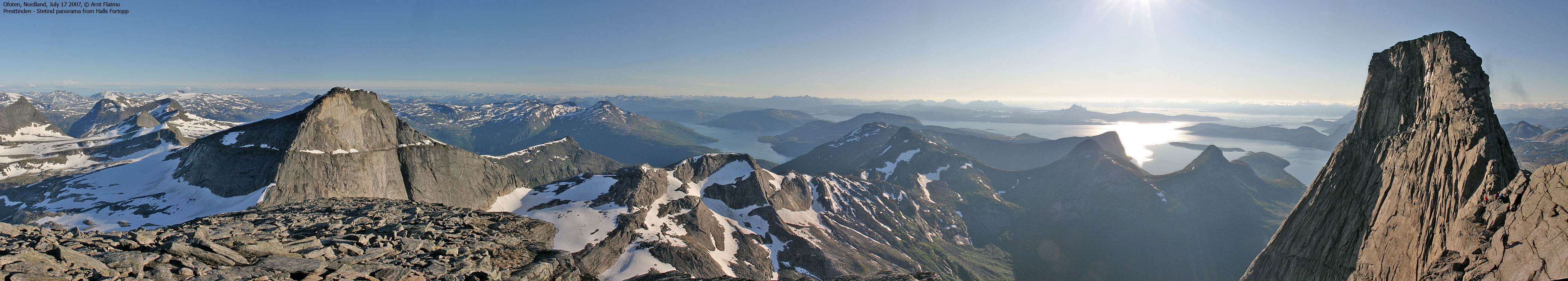
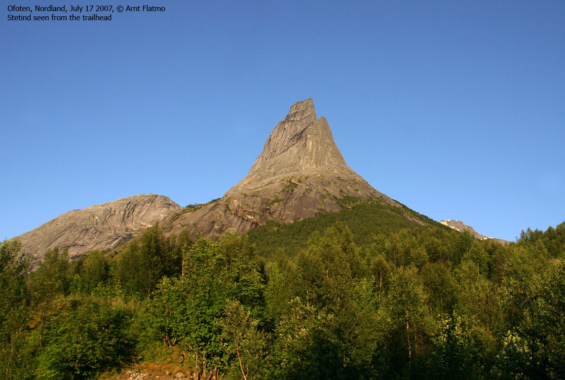
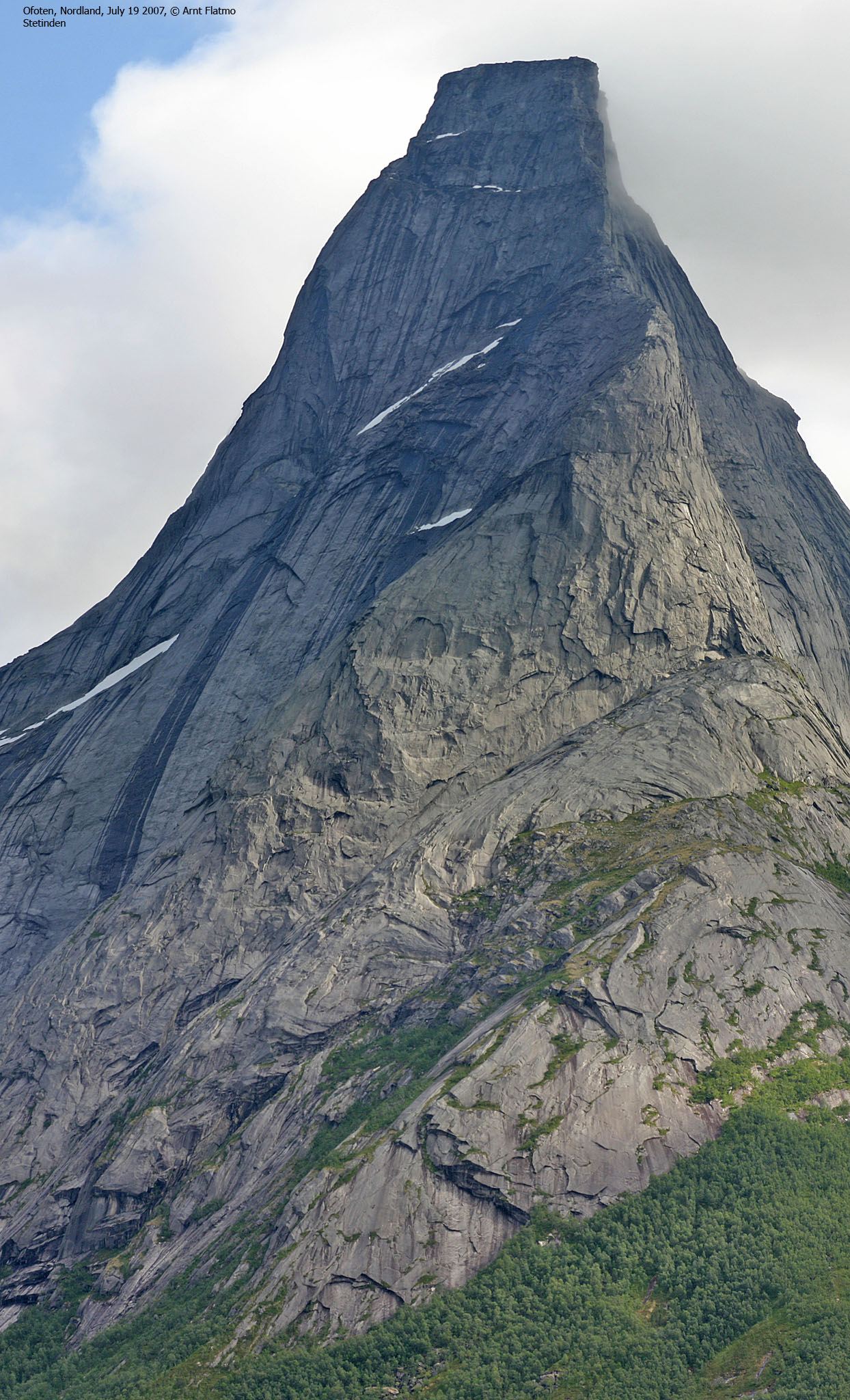
Stetinden, or Stetind as most people say, is a granite giant located in Ofoten (Nordland county), and the peak has historically been an important coastal landmark. In Norwegian climbing history, this peak is legendary, and has (unofficially) been voted to be the National Mountain of Norway. Just like Romsdalshorn - when you've seen the mountain from its finest angle, you'll never forget it. The mountain rises more than 1390m up from sea level and form a nearly flat summit plateau. Anvil-shaped, or as Peter Wessel Zappfe said it: an anvil whereupon the Gods can hammer.
The mountain is sacred to the Sami people, and is called Státtáchåkkå in the Sami language.

There are many legendary quotes. You can find many of the quotes, myths, legends and other practical information on the leading Stetind website - stetind.nu. Those of us who are not born with a gifted pen, may struggle in describing the sensation of being on Stetind on a perfect day. Here's one that found the proper words (Norwegian text):
|
Eivind Eidslott (Til Topps i Nordland, Forlaget Press 2002) |
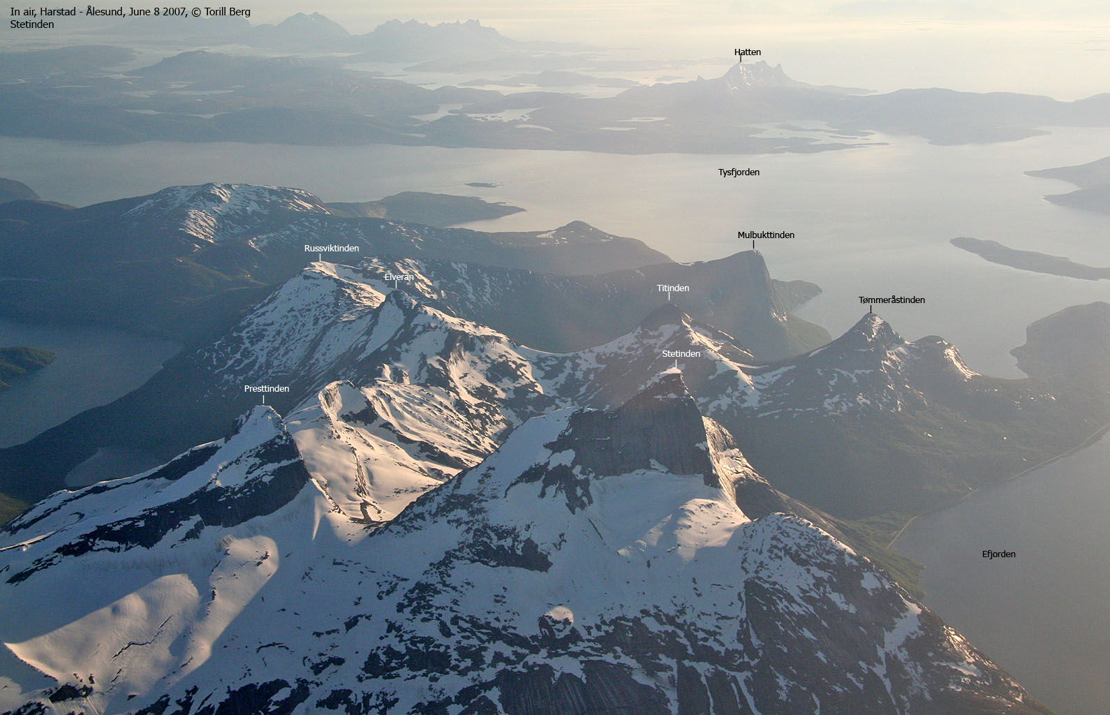
The first attempts on occured in the late 1880's by two Tysfjorden locals, one of them the Tysfjorden priest Olaf Holm. In 1888, Martin Ekroll attempted a Stetind ascent together with one of Germany's legendary climbers - Paul Grussfeldt. Later on, legendary climbers such as Carl Hall, Mattias Soggemoen and William C. Slingsby also failed in ascending Stetind.
It wasn't until 1910 that the Norwegian climbers Bryn, Schjeldrup and Rubenson completed the first ascent of the mountain. In Den Norske Turistforenings årbok (1911), Ferdinand Schjeldrup tells about the traverse below Mysosten (Norwegian text):
| Saa sluttet hylden helt, og svaet gik fra mysostens top ubrutt tildals. Vi forankret alle tre, Rubenson heldte sig utover og kek
rund hjørnet. -- Han vendte sig mot os. "Findes det nogen spræk der?"
"Ja" -- og litt efter, "jeg tror jeg rusler ivei jeg, get". Han lempet sig ut og hang saa i armene på 1000-metersveggen. "Har du bra tak?" "Saa langt jeg kan se, greier det sig nok". Han entret ivei bortover i langsom armgang. Det var ikke frit for, Bryn og jeg tællet sekunderne efersom vi gav ut tauget. |
When Bryn and Rubenson had completed the traverse, they "ran" up to the summit and concluded that there was enough space for a small village. At the time, the summit was covered by a glacier. They were also able to kill the myth about the Goldfish pond on top..
Later in the 1930's, Tysfjord locals, such as Simon Andresen, Olav Pettersen and Leif Nilsen ascended the summit of Stetind. The Norwegian climber (and philosoph) Arne Næss led a number of new routes in the 1930's, including the south pillar, and the first winter ascent took place in 1963 (on the normal route via Hall's Fortopp) by Arne Næss, Ralp Høibakk and K. Friss Barstad. In 1985, Vadla, Holmen and Pedersen climbed Stetind's north wall. The western wall was first climbed during the summer of 1966, by Arne Næss and Nils Faarlund.
Most, if not all routes has now been climbed during summer or winter. It is now prohibited to use bolts on the mountain. Nevertheless, you may find bolts on the normal route (via Halls Fortopp).

| A very frequent question is: Do I need to climb to reach Stetind?. The answer is yes. The succeeding
question is often: Is a rope needed?. The answer is yes.
The actual climb is very short and is moderately difficult (4+/5- on the Norwegian climbing scale). Good climbers will regard the climb as easy, but for "normal people" the climb can be a small challenge. Some climbers may even climb Stetind unroped, but it remains to be seen if those bold climbers live to be bold old climbers. The normal route to Stetind runs via Halls Fortopp (1314m), to which you can hike, with occasional use of hands. The ridge towards Stetind is narrow and exposed, and is a mix of scrambling and easy climbing. Mysosten is a cliff half-way across the ridge. You have to climb around this cliff, and this is the most difficult section. There is a 2-3 meter pitch where you have to climb using only your hands. There are no footholds. This section is known as De Ti Forbitrede Fingertak, and the normal procedure is to rappel down from Mysosten. Refer to the route description below for an in-depth explanation of the entire route. Unless you have friends who are climbers, there are several guiding companies that run trips up to Stetind. Use stetind.nu as your starting point. You can also call Stetind Hotell in Kjøpsvik for information. This is the nearest accomodation, only a 15 minute drive from the trailhead.
|

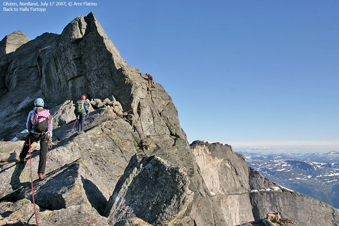
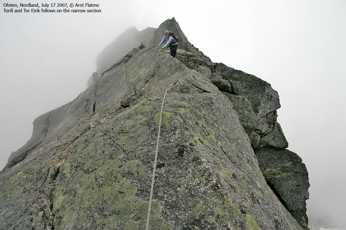
The route from Halls Fortopp to Mysosten

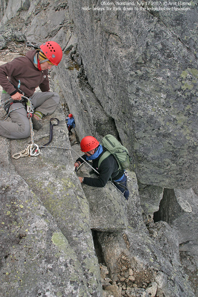
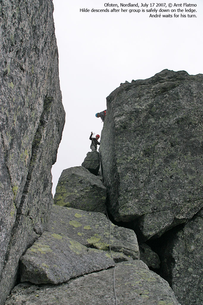
Climbing past Mysosten

The route from Halls Fortopp to Mysosten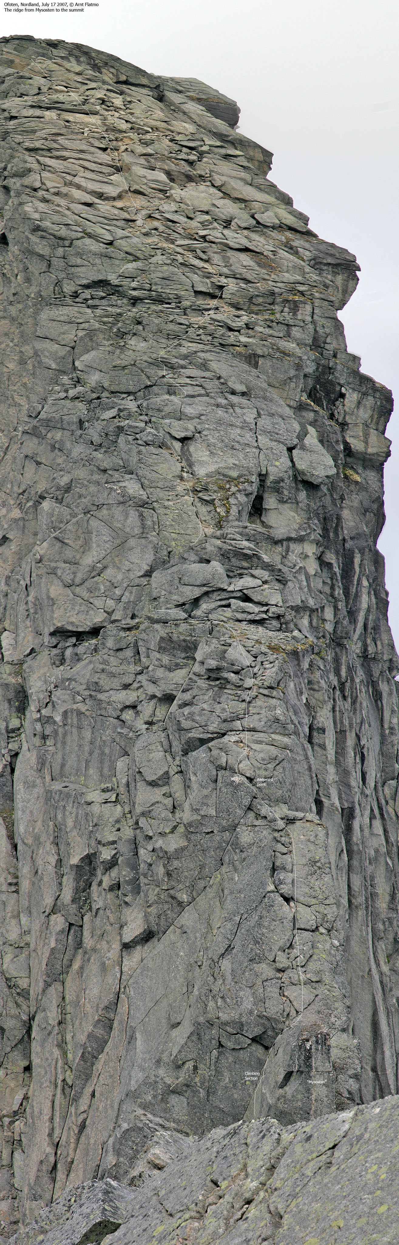
|
Two "faces" can be seen on Stetind. No existing names on these faces have been found during search on the internet, so until the "official" names come up (if any), this website refers to the two faces are Stemora and Stefaren. This translates to the Stepmother and the Stepfather, but the translation gives no meaning. The point is the prefix Ste, as in Stetind.

"Stemora"
|

"Stefaren"
|
Stetinden (Norge 1:50,000: 1391m, Økonomisk Kartverk: 1393,6m ~ 1394m, UTM 33 W 566057 7562130) has a primary factor of 604m, towards the higher parent mountain Isfjellet (1437m). There are two saddle candidates: a: between Kopptinden and Tauselvtinden (approx. UTM 33 W 572266 7558528) and b: between Saltelvtinden and point 1354m (approx. UTM 33 W 575567 7558352). Ref. Norge 1:50,000 (20m contours), these saddles are within the range 780-800m, interpolated to 790m.


Google's interactive map. You can zoom, pan and click on the markers.
Notes: Class ratings are in reference to YDS. Click here for more information.
The trails described below are not necessarily the *easiest* trails to this mountain.
|
Stetind via Halls Fortopp - normal route(summer/autumn)
|
|
Access
(all distances are approx. distances)
The closest larger city is Narvik. From Narvik, follow highway E6 to the
southwest. Pass the place Ballangen, cross Forsahavet across the islands Storøya
and Hallvardøya, and then turn left onto highway RV827 (Kjøpsvik). Follow this
road approx. 18Km, passing through Efjordtunnelen and Stetindtunnelen tunnels along the way.
Once you've passed Stetindtunnelen, turn left onto a large parking area. This is
the Stetind trailhead.

The route
From the trailhead, a path takes you up southbound in Storelvdalen,
alongside Storelva river. The path rises above the forest and towards
Lake Svartvatnet (728m), a good place for a rest and water refill.
The route (visible path) from the lake up to Halls Fortopp (1314m) runs
in rocky terrain. Some rocks are
loose. Caution is mandatory to prevent rockfall. The route has also a couple of
points where you'll use your hands to advance (YDS class 2+).
Halls Fortopp is marked by a proper cairn. The climbing begins here. The
rest of the route can be divided into three sections; a) to Mysosten (a
cliff that blocks further access), b) the traverse below Mysosten and c) up to
the summit. No matter you've been told, you will be better off wearing
climbing shoes ALL the way from Halls Fortopp.
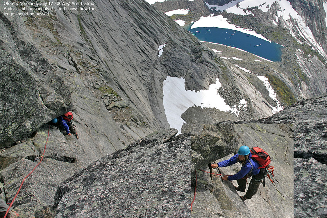
To Mysosten (YDS class 3):
The descent towards Mysosten
offers various types of manoeuvers, all of them exposed. The
first section is quite easy.
Then follows an exposed traverse
back onto the ridge where the rock is slick and the handholds aren't plentyful.
A short, but narrow section
follows. Climb on the side with your hands on top of the ridge.
The hardest point on this route may be the descent from the ridge down to a ledge below Mysosten. Per July 2007, a bolt was in place, allowing you to secure the most critical descending move with a sling.
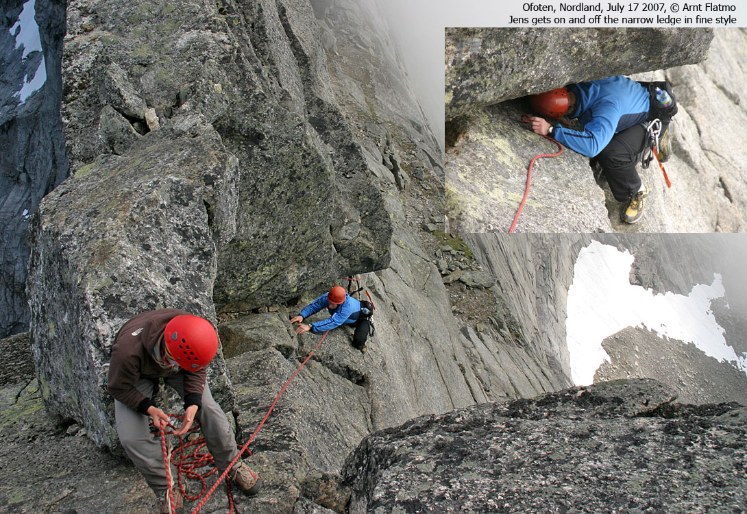
Passing Mysosten (YDS class 5.7):
From the ledge below Mysosten,
the next section runs across slab rock with screaming exposure. You
climb sideways (2-3 meters)
by holding your fingers on top of a crack ("De Ti Forbitrede Fingertak").
Per July 2007, 3 bolts were found where you exit from the ledge and begin the
climb. A sling for your foot will ease the move from the ledge to the crack.
There are no footholds, which means your butt needs to face down, and not
out.
Next, advance onto a tiny ledge
where space above your head is limited. Many will find this spot cumbersome.
There ARE handholds that enable you to get both your feet onto this ledge - a requirement for further progress. Or -
if your are experienced - one
foot will do. The rest of the (short) climb up to the ridge is easier. This
route is considered to in the range 4+/5- (Norwegian climbing scale), which
(roughly) converts to YDS class 5.7.
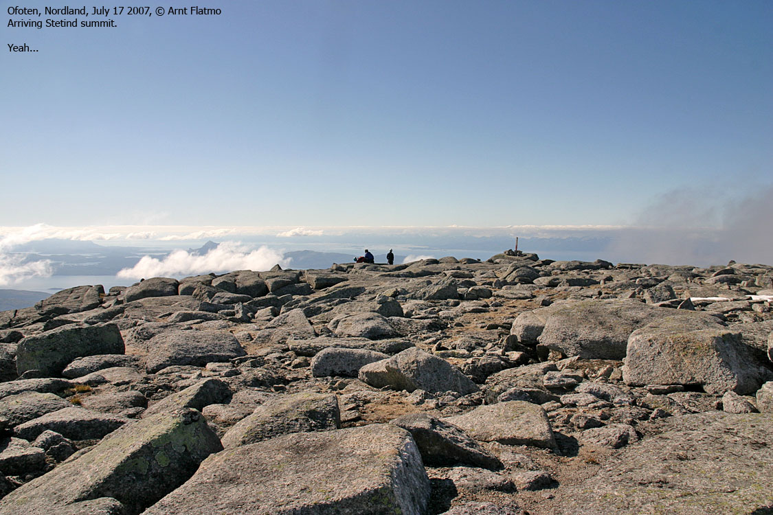
To the summit (YDS class 4):
The route up to the summit is
in general the easiest part of the climb. The hardest point on this route
(YDS class 4)
is climbing a small, but slightly awkward rise on the ridge. A bit higher up, a
rack of large rocks block the ridge. Bypass them down on your left-hand side.
Then follows an easier section.
You'll pass a few exposed and awkward points before you reach the HUGE
summit plateau. A small cairn
marks the high point. The viewpoint cairn is located further down - 60m to the
northwest.
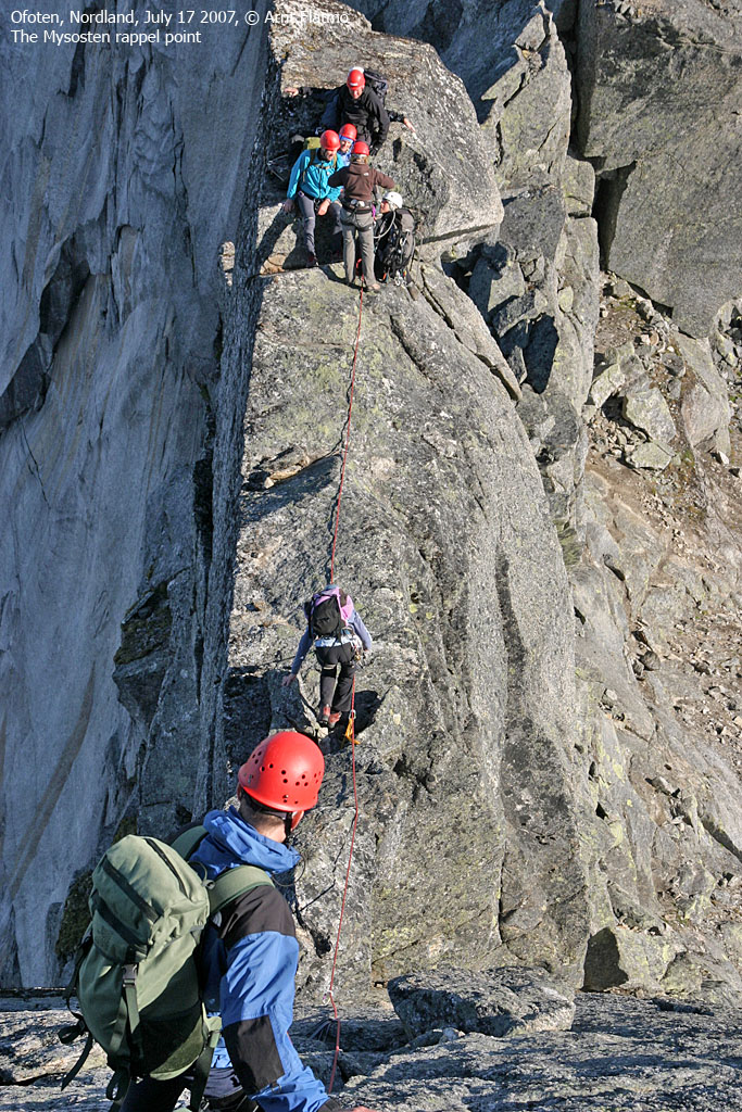
Descent:
Your descent route follows your ascent route, with the exception of Mysosten. A
(approx.) 30m rappel is the
normal
way of descending to the ledge. Two 50m ropes are needed. You'll find a good
place to anchor, and
the rappel is uncomplicated. Avoid jamming the rope in cracks as you pull
it down.
The reascent of Halls Fortopp is far easier than its descent.
Comments:
The last member in a running belay is very exposed if the member in front should
take a fall. Consider letting
the last member set up a temporary anchor while the second last member descends
exposed pitches. This depends of course
if there is enough rope between the members.


No Javascript:


