
For Information, maps, trailhead and route descriptions, click HERE.
When I looked out my window this Saturday morning, I saw sunshine above the Haram mountains, and irrespective of the weather elsewhere, I decided to visit Storfjellet today. This might be the last chance this season to ski this mountain. The weather works hard on the Haram mountains, and there is normally little snow on the mountains.
On my way to Haram, having wiews towards the other directions, I noticed that Haram was the only sunny region around. I didn't have a clear plan about the route, but turned onto the Hellandhamn road and drove until I saw the "Hellandshornet" trailsign.
I looked up the mountain and couldn't see any snow below 300m elevation, and prepared mentally for a hike/ski-trip combo. I left the trailhead with my dog "Troll" in the backpack, the poles on the backpack and the skis in my hands. I couldn't quite figure out where the trail was, but followed a vague path soutbound. This path didn't take me to the mountain, so I headed off-trail up a slightly cumbersome forest that only got steeper and steeper.
It had taken me close to an hour to get to the snow, and I was very happy when I could put the skis on. The snow was hard as ice and I let Troll out of the backpack. I had a 400 vertical meter steep slope ahead of me, before I reached Skjerveheian. I didn't look forward to ski down here. Not even half a centimeter of snow above the hard crust. Good for the dog, bad for me.
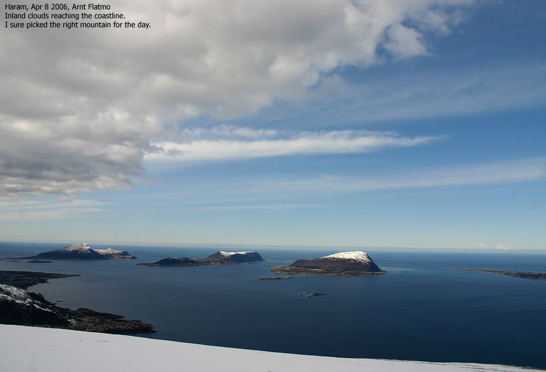
I felt the sensation of spring, leaving a colorful, snow-free Brattvåg behind, and heading up to the white mountains. The blue ocean and fjords added value to this sensation. There was a cold wind that forced me to dress for winter, and I was convinced I was alone on this large mountain. The cloudy sky that dominated Sunnmøre would probably not cover the Haram mountains until I was back down. So far, it was a great day.
Hellandhornet's NE ridge felt steeper because of the hard snow, but didn't offer any problems. We reached the top 12:50PM, and I was very curious about the south ridge, taking me further to Keipen. On the map, the ridge looked trivial, but you never know until you get there. There were *a lot* of cornices on this ridge, but I was able to descend it with skis on. Troll was once again confined to the backpack.
13:30PM, I reached Keipen summit. This isn't a real mountain, but is a very fun top to visit. The number of standing rocks was impressive, and the tallest was just amazingly tall. Next, I continued along the Keipen - Storfjellet ridge and got the "glacier feeling" on my way towards Storfjellet. We reached this top 13:50PM, and had earned lunch.
I was considering if I should include Urfjellet on this trip, but realising I knew nothing about the descent into Ringstaddalen, I chose to come back for Urfjellet in the near future. It felt good to remove this skins and let the skis flow down the mountain. Instead of returning across Hellandshornet, I skied into Ævelsdalen valley, minimising the vertical gain.
Back on Skjerveheian, Troll was let out of the backpack again, ready to walk the rest of the way. But the icy slopes below Hellandshornet frightened him. He carefully made his way to a snow-free turf and was "stranded". Skiing down with Troll in the backpack was not fun, but we made it down to the snow-free Høgenosa ridge safe and sound. I had seen the summer path from high above, and would follow this down. Troll walked all the way down this very steep (but safe) ridge, and we were back at the trailhead 15:15PM. All in all, it had been a great, yet strenuous trip.
To the trailhead


To Hellandshornet


360 deg. wide-angle panorama from Hellandshornet

50mm panorama from Hellandshornet, 2 parts


To Keipen


To Storfjellet


50mm panorama from Storfjellet, 2 parts


Zoom panoramas from Storfjellet


Descent


No Javascript:
1 2 3 4 5 6 7 8 9 10 11 12 13 14 15 16 17 18 19 20 21 22 23 24 25 26 27 28 29 30 31 32 33 34 35 36 37 37 39 40
 westcoastpeaks.com
Other Møre & Romsdal mountains
Other Norwegian mountains
westcoastpeaks.com
Other Møre & Romsdal mountains
Other Norwegian mountains