
|

Storhornet seen from Høgenakken
|
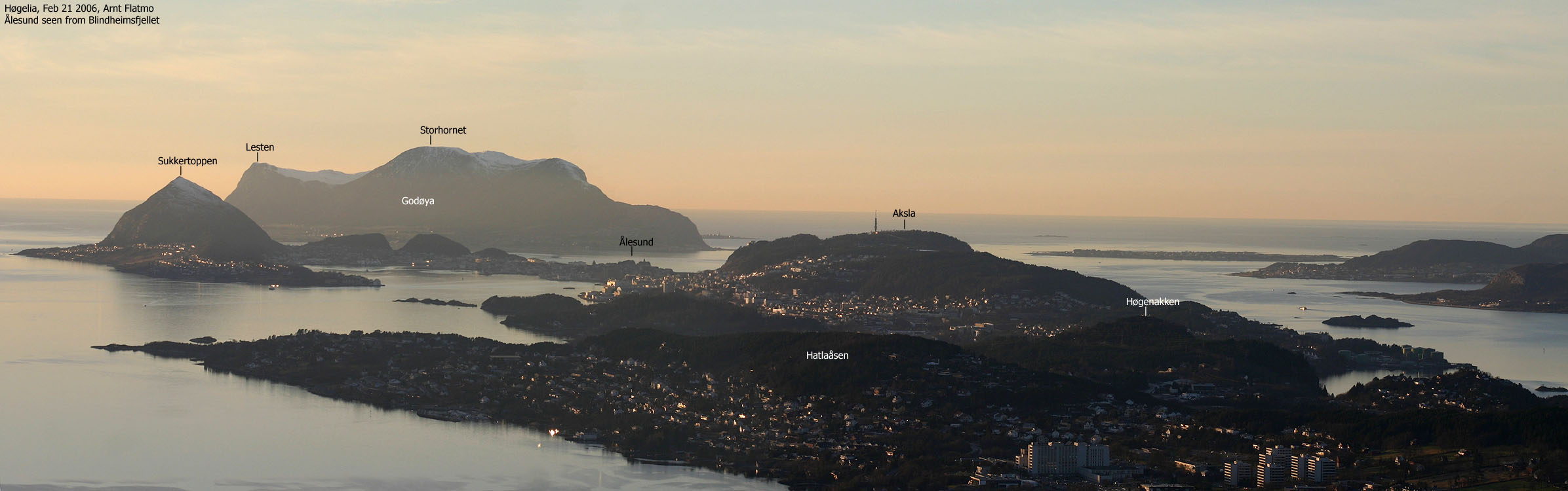
| Storhornet (Big Horn) is the high point on the island Godøya, located just outside the city of Ålesund.
Lesten and Sloktinden are the other tops on this island. The normal routes up to the mountain plateau run from Alnes on the north
side, Gjuv and the school on the south side. All trailheads are described on this page.
Storhornet appears as a mighty wall when seen from the city of Ålesund, and the peak has a perfect cone-shape when viewed from the west. It is no coincidence that this was the first mountain I chose to visit, after moving to Ålesund. Access to these tops has been made easy thanks to the Ellingsøytunnelen, Valderøytunnelen and Godøytunnelen underwater tunnels, as well as trails to all the tops. The island tops offer superb views towards Ålesund, the coastline and the endless chain of wild Sunnmøre mountains, frequently refered to as the "Sunnmøre alps". If you ever have one free afternoon in Ålesund, make sure you get to visit the Storhornet summit.
|
Lesten is
not the correct name for the 400m top. Lesten is a Norwegian word for a
foot, and in this case, the west side of Godøya is the foot and the
Lestaskjeret reef is the toe. On the map, Lesten is point 357m, located
685m north of the high point.
The 400m high point does (remarkably enough) not have a name. On your way from Gjuv, you will pass a small point just south of the Kallefonna couloir. This point is named Stølsnibba, but the high point 400m to the west does not have a name. Before I learned this, I have refered to the high point as "Lesten" on all pictures, and will continue to do so, at least so I remain consistent. |
Storhornet (M711: 497m, ø.K.: 497,04m) has a primary factor of 497m being the Godøya island high point.
Lesten (M711: -, ø.K.: 400,5m ~ 400m) has a primary factor of 122m towards the higher parent mountain Storhornet (497m). The defining saddle (approx. UTM 32 V 343991 6930152) is found in the pass between the two tops. Ref. økonomisk Kartverk (5m contours), the saddle is within the range 280m-275m, interpolated to 278m.
Notes: Class ratings are in reference to YDS. Click here for more information.
The trails described below are not necessarily the *easiest* trails to this mountain.
|
Gjuv - Storhornet - Lesten (all seasons)
|
|
Access
From Ålesund, follow highway RV658 towards Vigra (airport). Between the Ellingsøytunnelen and Valderøytunnelen undersea tunnels you have to pay toll. Per Dec 2005, the toll fare for passenger cars was NOK 60,-. Just after Valderøytunnelen, turn left towards "Godøya" and drive to the island Giske across a bridge. Follow signs towards Godøya and drive through yet another undersea tunnel - Godøytunnelen. Once on Godøya, follow the "Godøya Sør" (south) sign and drive approx. 3,8Km. Turn right onto a smaller road that runs upwards. After 400m, you see parking on your left-hand side and a trail map. This last section of the road is a loop. In other words, you can keep on driving and end up on the road you came.
The route
Storhornet
Walk across the road and follow a paved road up to the first house. When the road turns left, the trail continues straight ahead. Follow this well-worn trail all the way to the the pass between Lesten and Storhornet. Turn right and follow a path that leads up the ridge to Storhornet. High on the Storhornet ridge, you pass a section with a fixed chain for handhold. This section is not very difficult, but can be awkward when icy. There are also alternative routes if you care to look. The Storhornet summit is marked by a trig. point and a large cairn. You will also find a visitor's register by the cairn.
Roundtrip
Descend your ascent route, or; continue across Storhornet and follow a narrow path that takes you down to the lake. There is a trail junction at approx. 450m elevation where you turn left. This path stays close to the steep side of the mountain and takes you down to the north end of the lake.
Walk along the lake on path and decide how you want to approach Lesten. Once on the Lesten high point, make sure you follow a path a bit to the west so you can see the steep cliffs. Follow Lesten's east ridge back to your ascent route. This route has a short, awkward and fascinating section - fascinating because making the trail just about everywhere else would have been better.
Johan Skytt
"Johan Skytt" is a characteristic ledge that can be seen on the trail between Alnes and Alnesvatnet. You will see the location on the map at the trailhead.

|
Alnes - Storhornet (all seasons)
|
|
Access
From Ålesund, follow highway RV658 towards Vigra (airport). Between the Ellingsøytunnelen and Valderøytunnelen undersea tunnels you have to pay toll. Per Dec 2005, the toll fare for passenger cars was NOK 60,-. Just after Valderøytunnelen, turn left towards "Godøya" and drive to the island Giske across a bridge. Follow signs towards Godøya and drive through yet another undersea tunnel - Godøytunnelen. Once on Godøya, follow the "Alnes" sign and drive all the way to the place Alnes. Locate the local grocery store and park there.
The route
Pass the store on your right-hand side (west) and follow a paved road for a few meters. Turn left on a road that leads to a farm. Walk through this farm and locate the beginning of the mountain trail. After passing a gate, follow a wide and well worn path all the way to Lake Alnesvatnet.
Turn left by the trailsign "Storhornet", head towards the northeast end of the lake and choose between two paths that run up the mountain. You might as well follow the path closest to the mountain. Higher up, this path merges with the other path. Continue up to the summit, marked by a trig. point and cairn. You will also find a visitor's register by the cairn.
Descend your ascent route, or traverse the mountain and walk around the south side of the lake.
|
Godøy school - Sloktinden (all seasons)
|
|
Access
From Ålesund, follow highway RV658 towards Vigra (airport). Between the Ellingsøytunnelen and Valderøytunnelen undersea tunnels you have to pay toll. Per Dec 2005, the toll fare for passenger cars was NOK 60,-. Just after Valderøytunnelen, turn left towards "Godøya" and drive to the island Giske across a bridge. Follow signs towards Godøya and drive through yet another undersea tunnel - Godøytunnelen. Once on Godøya, turn right towards "Godøya Sør" (south) and drive approx. 800m. Turn right towards "Godøya Skule" and drive approx. 800m. Locate a trailsign on a pole on the right-hand side of the road, approx. 200m before the school.
The route
The route used to run from the school earlier, but because of road work, it has been moved. The path runs across a field, directly towards the Valkveegga ridge. The path is well mark, and you will have no problems following it all the way to the ridge. On Valkveegga, turn left and follow the path up to the summit. There are no scary parts along this route, even if the east side of Sloktinden may appear steep from distance.
Descend your ascent route, or continue to - and traverse Storhornet and descend to Gjuv. You have to walk 2,3Km along the road in order to get back to the trailhead by the school.


Godøya offers a number of fun off-trail routes. Some will be described here (ref. picture above). The trailheads are Gjuv on the south side and Alnes on the north side of the island. To get to the Gjuv island, drive as far as the road runs westbound, and just as the road loops back around, turn left onto a tractor road. Park here.
On the Alnes side, turn left by the school and follow the road that runs westbound, along the bay. Park at road end.
Kallefonna
The Kallefonna couloir is only 1Km from the Gjuv trailhead. It is for the most part a long boulderfield, and grass in the upper part. This is perhaps the easiest of the off-trail routes, as you never need to use your hands other than for balance. The upper part is not especially steep. The couloir tops out between Stølsnibba and the highest point on Lesten. Follow a path eastbound down to the Storhornet trail, and then back to Gjuv. Classification: 2 (YDS)
Moldagjølet
The Moldagjølet couloir begins 1,8Km from the Gjuv trailhead. Follow the marked route along the coastline, and just as you have passed the pothole, the couloir begins straight ahead of you. At first, narrow and almost hidden. The couloir gets gradually wider and steeper. A slab section may be bypassed when wet. The couloir has loose rocks, so a party of two or more need to be very careful.
At approx. 200m elevation, you need to exit the couloir and get on the ridge up to your right. The exit point is the hardest section of the route. The terrain is steep, and there is only grass to hold onto. Once on the ridge, follow it all the way up to the plateau. Follow a path eastbound down to the Storhornet trail, and then back to Gjuv. Classification: 3 (YDS)
If you decide to continue up the couloir, as opposed to getting onto the ridge, you'll face a steeper section that is very exposed. If you make it up here, you can follow the couloir upwards, and eventually join the ridge route. There is another couloir on the left-hand side. Don't get into this one.
The West Ridge
The west ridge route begins approx. 2,5 from Alnes and from Gjuv. The fastest route runs from Alnes. The ridge is steep down by the shore. Enter it on the north side, or bypass the initial section on the south side. Once on the ridge, you will notice a distinct gully that runs up the ridge. Follow this gully up to a plateau at 200m elevation. Head eastbound (you may see a vague path) up to the plateau. Follow the plateau path towards Alnes or Gjuv. Classification: 2+ (YDS)
Måsegjølet
The Måsegjølet couloir begins 1,8Km from the Alnes trailhead. Follow the route along the shore until you have the couloir in view. You can either ascend a steep boulderfield, or ascend on mixed terrain further south. Once inside the couloir, switch back and forth, in order to avoid directly exposed terrain. The couloir is steep, but OK on the easiest route. One point in the middle of the couloir requires the use of hands in order to proceed. The rest of the route is just steep terrain. Once on the plateau, follow the plateau path towards Alnes. Classification: 3 (YDS)
In a hurry? Check out the "20 good moments on Godøya" picture gallery.
 westcoastpeaks.com
Other Møre & Romsdal mountains
Other Norwegian mountains
westcoastpeaks.com
Other Møre & Romsdal mountains
Other Norwegian mountains

