
Norwegian Mountains, Møre og Romsdal"Dravlausegga", 1059m (ca.)
|
| Fylke/Kommune : | Møre og Romsdal/Sykkylven | ||||||||||
| Maps : | 1219-IV Sykkylven (Statens Kartverk, Norge 1:50 000) | ||||||||||
| Primary factor : |
"Dravlausegga": 539m Straumshornet: 134m |
||||||||||
| Hiked : | July 2007, Aug 2008 | ||||||||||
| See also : |
| ||||||||||
| See also : | Other Sykkylven mountains |
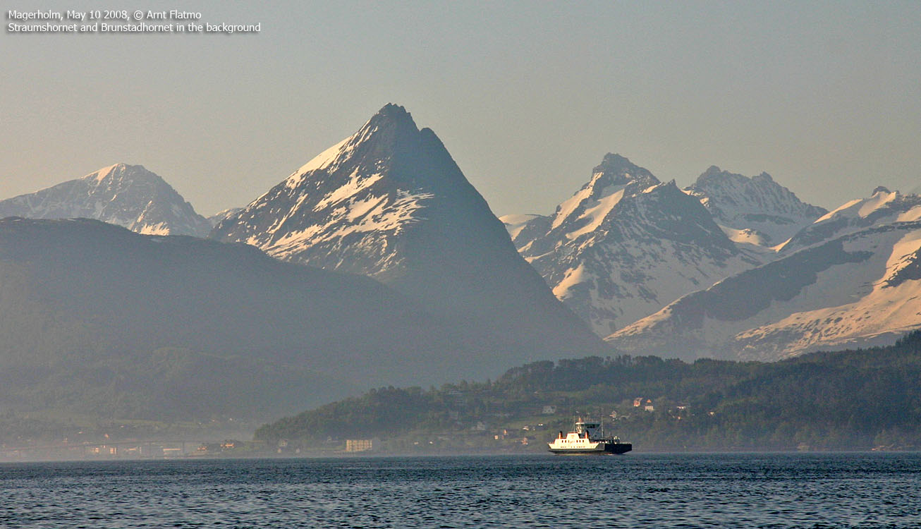
Straumshornet (center)
(Click for larger image)
"Dravlausegga" is a name that westcoastpeaks and fjellinordvest is using for the mountain massif on the east side of Velledalen. Straumshornet is the northernmost (and the most popular) peak. To the southeast, you will find the trigonometric point 1056m, followed by the unnamed high point (ca. 1059m), Dravlausnyken (980m) and Tretindane (922m). The ridge connects to Urfjellet through the Koppen pass.
There are a number of map errors (per Aug. 2008) that one should be aware of. First, Dravlausnyken is associated with the 1085m trig. point. Dravlausnyken is however a characteristic top 1,3Km to the southeast on this ridge. Furthermore, the map fails to point out the high point - a few meters higher than point 1085m, and 240m to the southeast. Also note that on Økonomisk Kartverk, the Straumshornet trig. point (976,35m) is north of the 980m contour.

Dravlausegga and Straumshornet
(Click for larger image)
Straumshornet is easy to reach on its easiest route, although the trail is steep and exposed in the upper part. People with a low tolerance for heights should visit the Dravlausegga high point instead, which has absolutely no exposure on the easiest route. The route to Straumshornet begins at the end of the north ridge, while the route to Dravlausegga begins at Langenessætra. The ridge connecting Dravlausegga and Straumshornet should be considered as a climbing route, but Dravlausegga offers a nice round trip option. The Dravlausegga round trip can also be skied, but at least one spot may require an ice-axe and/or crampons. See below for route descriptions.
Hardly arguable, Straumshornet is one of the most characteristic peaks in Sykkylven. The peak bears a close resemblance to Liadalsnipa in Ørsta, both in appearance and shape.
Straumshornet (Norge 1:50,000: -, Økonomisk Kartverk: Highest contour is 980m, UTM 32 V 376647 6913473) has a primary factor of 135m, towards the higher parent mountain Dravlausegga (1059m). The saddle (approx. UTM 32 V 376823 6913301) is found along the ridge between the tops. Ref. Norge 1:50,000 (20m contours), the saddle height is within the range 840-860m, interpolated to 850m.
On the Norge 1:50,000 map, the trig. point is defined as 976m. This is probably the lower viewpoint. Looking at the Økonomisk Kartverk map, one can see a 980m contour. Personal GPS measurements, on top of the cairn, averaged over 20 minutes, read 988m. After correction for error margin, 984m has been set as a possible elevation.
Dravlausegga (Norge 1:50,000: -, Økonomisk Kartverk: Highest contour is 1040m, UTM 32 V 377164 6912489) has a primary factor of 536m, towards the higher parent mountain Urfjellet (1267m). The saddle (approx. UTM 32 V 379511 6910156) is found in the Koppen pass, between the two mountains. Ref. Økonomisk Kartverk (5m contours), the saddle height is within the range 520-525m, interpolated to 523m.
GPS measurement on the summit cairn (0,5m high) read 1065m, averaged over a 5-minute period (error margin +/- 2,1m). This point is approx. 240m southeast of the 1056m trig. point. The high point seems only a few meters higher than the trig. point, and the suggested height was set to 1059m to be in accordance with the non-existing 1060m contour.
Dravlausnyken (Norge 1:50,000: 980m, Økonomisk Kartverk: 980m, UTM 32 V 377631 6911530) has a primary factor of 35m, towards the Dravlausegga high point.
Tretindane (Norge 1:50,000: 922m, Økonomisk Kartverk: 922m, UTM 32 V 378080 6910665) has a primary factor of 72m, towards Dravlausnyken (980m).
Google's interactive map. You can zoom, pan and click on the markers.
|
|
|
|
Route 1: Straumshornet via the north ridge (summer)
|
|
Access
The following route description was valid for July 2007. All distances are approx. distances.
Ålesund is the nearest larger city. From Ålesund, follow highway E39 towards Bergen, and then highway RV60 (Stranda) to the Magerholm - Ørsneset ferry (towards Sykkylven). This ferry runs quite often; every 20 minutes in the busy hours of the day. From Ørsneset, follow RV60 (Stranda) 4,3Km. Turn left towards Vik (just before Esso gas station. Drive up to the next junction and turn right. Drive 6-700m and turn left (next to the Hydro station)
After 600m, you reach an unmanned toll booth (NOK 20,- for passenger cars). After 3,3Km, turn right onto Straumsdalsvegen. 300m later, you reach another unmanned toll booth (NOK 20,- for passenger cars). 1,6Km after the Straumsdalsvegen junction (and 1,3Km) after the toll booth, turn right in the road fork. Start look for parking along the road.
Click here for an overview of the roads.
The route
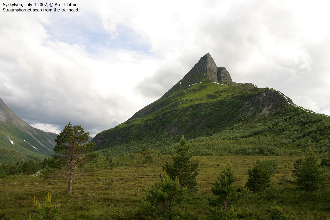
Straumshornet seen from the trailhead
(Click for larger image)
From the trailhead, head towards the fence around that enclose the field ahead of you, and pass on the right-hand side. When the fence turns east (left), turn right and locate a faint tractor road that takes you towards the forest and the path. The forest path up the ridge is narrow, but easy to follow.
Above the forest, you run into a cliff. There are several routes (up and around). You'll find enjoyable scrambling here, if you step outside the path. The path continues directly towards Straumshornet, before it traverses Straumshornet's eastern hillside.
Fetråsa is a path that forks up to the right in this hillside (you'll have to look for it). This path runs directly towards the top. Be aware of loose gravel. Don't stumble! Expect to use your hands to pull yourself up a few places.
If you pass Fetråsa, follow the hillside path a little while longer, before it heads steep up along a ridge. There are several variations to this route, and some may lead you into terrain that is steeper than on the easiest route.
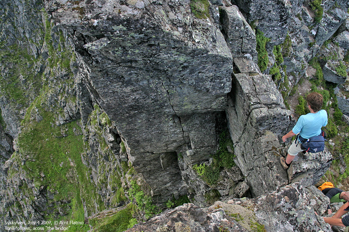
When you reach a point where you see a hole in the summit ridge, you can either go up to the left and cross "the bridge" above this hole, or turn right and follow a path below the summit ridge. Claim "extra points" if you walk "the bridge" without holding on to anything..
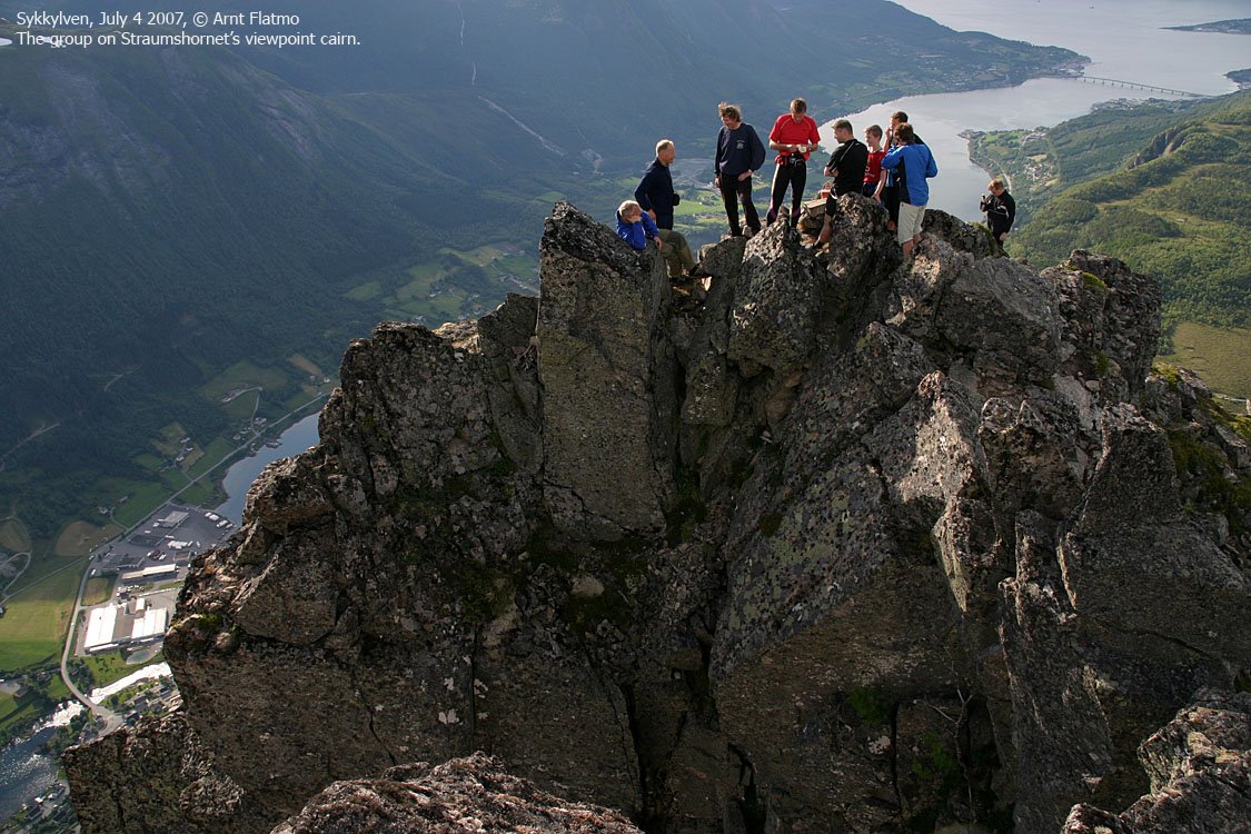
The summit is marked by a modest cairn. The visitor register is located in a small cairn a bit further northwest. This is perhaps point 976m. There is an airy section in-between, but you can descend to the right, and avoid the airy section. Claim additional "bonus points" if you climb the ridge in-between. It is much easier to climb this ridge towards the viewpoint cairn, opposed to climbing back towards the summit cairn.
The best route for descent is a subjective matter. While Fetråsa is full of loose gravel and has a couple of awkwards slabs, the ridge route (from "the bridge") has more natural steps. The ridge route is however equally steep.
|
Route 2: Langenessætra - Dravlausegga round trip (summer)
|
|
Access
See access for Straumshornet via the north ridge above. After you've turned right in the last fork, drive 400m, then turn left and follow the road to the Langenessætra parking area, 2,5Km from the road fork.
The route

The round trip route
(Click for larger image)
Proceed down to Lake Langenesvatnet, and follow a path along the lake's west shore. After 600m, you might just as well go off-trail into the birch forest and make your way up to the flank. Once you're on the flank, maintain a northwest bearing (on gentle terrain) until you reach the 1056m trignometric point. If you're interested in exploring the ridge towards Straumshornet, then the ridge is fairly easy for approx. 300m before you will have to consider your future (this is for experienced hikers!).
But back to the round trip; from the trig. point, head towards the high point, 240m southeast of the trig. point and marked by a small cairn. Continue towards an unnamed top (approx. 1030m) before you reach Dravlausnyken, which is marked by a small cairn. Looking back, the ridge looks quite impressive. Proceed across Tretindane (high point not marked), before you begin the descent towards the Koppen pass.
Find a good route along the creek draining to Langenesvatnet. At the lake's south end, you'll pass a nice picnic area before you find the trail near the southeast corner of the lake. Follow the path all the way back to Langenessætra.
.
|
Route 3: Dravlausegga from Hjorthol (summer) See the Urfjellet page
|
|
 westcoastpeaks.com
Other Møre & Romsdal mountains
Other Norwegian mountains
westcoastpeaks.com
Other Møre & Romsdal mountains
Other Norwegian mountains


